
The weather pattern continues to be unseasonably warm in most areas of the West. A weak wave will tease the Sierra at upper elevations in the next 48 hours and extend into Utah and Colorado for some dense snow above 7500 feet in Utah and Colorado. Overall, this system is very warm and will limit Sierra snow to upper elevations in the Sierra and above 8,000 feet in Utah/Colorado (light amounts).
The extended pattern is very unsettled, with perhaps the Sierra scoring several feet of powder, with the highest totals above 7500 feet.
Below: Moisture with warm air brings moderate totals to the peaks of the Sierra and light to moderate teases for areas above 8,000 feet in northern Utah and western Colorado. General totals in Utah and Colorado are between 2-5 inches above 8500 feet. There is a slight chance that areas near Crested Butte grab higher totals. Bottom Line: Warm with high snow levels and some creamy powder. Not a chaseable event.

The extended forecast is very active, with some details still unclear. There are multiple storms that are going to favor the western BC mountains, and some significant moisture for the Sierra for most of the weekend into late next week. Colder air moves in by mid to late next week and might be a good signal for the 4 corners and Wasatch.
Heli Alert: The Tetons have been getting a lot of high-quality snow, especially above 7,000 feet. Our Gold Sponsor, High Mountain Heli, has seats available in the first few weeks of January. If you want to avoid lift lines, ride untracked powder. We can testify that the conditions have been deep. Take advantage of open seats now!
The Extended Forecast is below:
SUPPORT OUR GOLD SPONSORS


 There are several systems to watch beginning this weekend, early next week, and again midweek. The trend will be 6,000-foot snow levels in the Sierra with colder air due by mid to later next week. That final push of moisture mid to later next week might push into the 4 corners with cold air and double digits.
Storm #1- This weekend.
Below: 4800-foot temperatures highlighting well above freezing in most areas of the west at the beginning of this loop, Friday (January 2), with some cooling noted towards the weekend in BC and the northern PNW (End of the loop). Snowfall will increase in the western BC mountains, including Whistler, as temperatures cool by Saturday afternoon.

Below: Total snowfall from this weekend favors the western and southern BC ranges, and the Sierra Range. Double digits are likely at Whistler (Mid to upper elevation) and many spots in the Sierra. Red Flags: Temps are still warmer than average, and rain will be falling at lower elevations below 4,000 feet in BC and the PNW. Positives: Some dense double digits should fill in the upper and mid elevations of western BC and Sierra, with some moderate snow for the Cascades, and interior BC.

Below: 10K foot temperatures in the northern Sierra this weekend are -6 °C (21°F), which drives snow to the bases of most resorts near 6,000. There is warmer air noted south of this boundary (southern Sierra) with Mammoth likley seeing warmer temps but benefiting from higher altitude. Double digits will likely be confined to 8,000 feet and above with this storm in the Sierra.

Storm #2- Monday to Wednesday next week
Below: A second and more potent surge of moisture is aimed at the Sierra, perhaps on a continual fetch of moisture from Monday to Wednesday next week (January 5-7). This storm will also be on the warm side with snow levels near 6,000 feet (Near the bases of many resorts). Snow quality will be dense. Winds are surprisingly not too strong either, primarily from the S, SW in the Sierra.
Areas of BC and perhaps the northern Cascades also grab snowfall, albeit moderate totals.

Below: Looking out from Wednesday, January 7, to Thursday (Jan 8), moisture from the Sierra moves south into the 4 corners with some possible decent totals noted for this region and into the Wasatch range. The Tetons might be just south of the highest totals (Moderate snow), with the Four Corners in the best position currently. Caveat: We are outside the range of confidence, but this is at least a good signal for resorts that have not seen snow in a long time. The Sierra may also continue to fire with lower snow levels.

Below: Optimism exists for the mid to later next week with colder air finally moving south over the Sierra and into the southern Rockies and Four Corners (January 7-9). Let's hope the models combining mid to late next week's snowfall and colder temps stay on track.

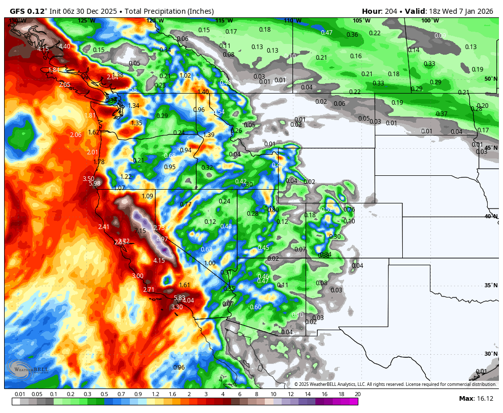
Below: Total moisture is significant for the West peaking this weekend into the middle of next week (3 systems). Nearly 5-6 inches of water for the Sierra with this map ending January 7th next week.

Chases: BC higher elevations this weekend (Western BC will grab higher totals) into early next week. Sierra ranges Monday-Thursday (Higher elevations above 8,000 feet for medium to dense deep snow). Midweek chases from the Sierra (colder) to the 4 corners, perhaps the Wasatch range as moisture funnels north. The Tetons are also a wildcard.
Bottom Line: Still high snow levels aside from some cooler air for BC this weekend and early next week. The heaviest mositure surge is aimed at the Sierra next week. Colder temps and a Four Corners storm are possible mid to later next week, where quality might improve.
Please help us out if you read our free forecasts by considering some of our high-quality merchandise in our powderchaser store.
HELP US OUT- Please support your love of powder and our free forecasts with a donation here, or join our concierge program. We have merch on the website.
We appreciate the support.
Forecaster: Powderchaser Steve @powderchasersteve (Insta).


