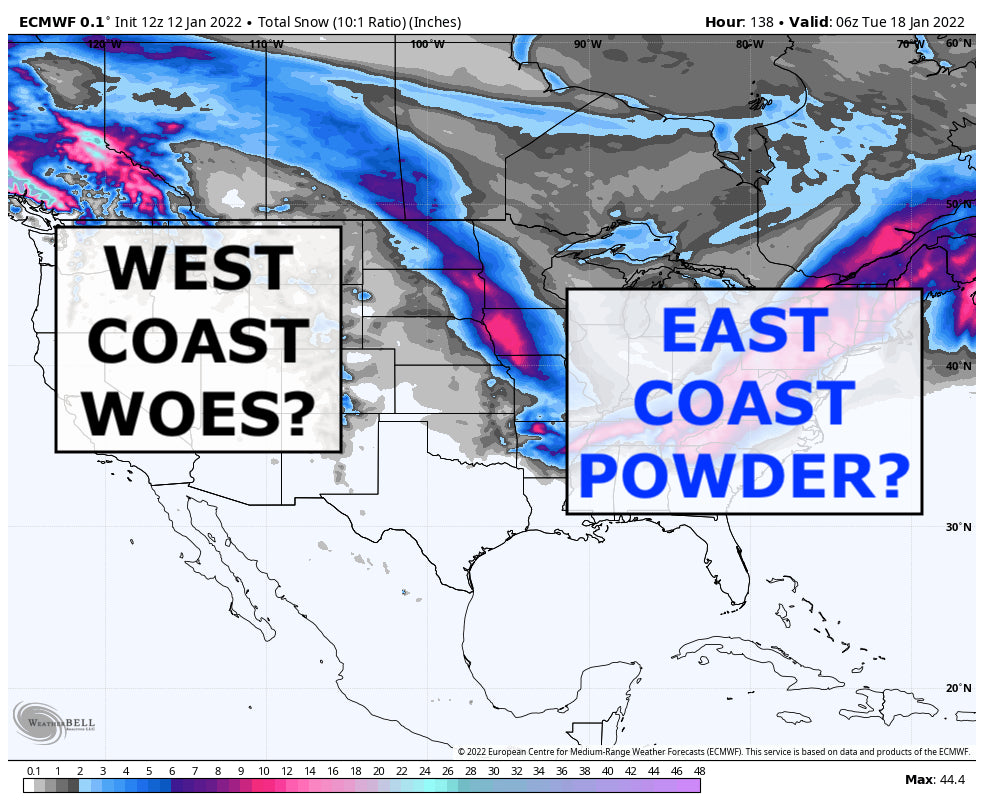
Well, the tables have turned and we are watching big powder possible for the East Coast while the West Coast struggles to get any fresh snow. We'll jump into the specifics of that storm below but first, let's look at snow totals from the last 3 days (Sunday-Tuesday). Also, if you want to chase powder to the best locations and need custom information not found in our posts join our Concierge program. Or simply donate to Powderchasers if you simply like reading our forecasts. We are a small group of Powder lovers that does this to get the best information out there.

Slim pickens for fresh snow this week. You have to head to the high elevations of the Washington Cascades to find fresh powder but even at the higher elevations, the snow quality is a little creamy since temperatures have been so warm. We mentioned that some ski areas closed yesterday and today due to RAIN falling. Not ideal. That ridge that is keeping the west warm and dry does not look to budge much over the foreseeable future. It's almost a complete flip-flop from the very active pattern that recently ended.
The incoming weather is going to offer the slightest glimmer of hope for a new layer of fresh snow - for some. A cold front with push onshore to Washington/Oregon starting Thursday and will continue inland towards Montana before shifting south towards Colorado. Fun fact, this is the storm that will go on to produce big snows for the east. For the west, this will be a mediocre storm bringing no more than 6\" at most to favored areas far north. Otherwise this storm will produce about 1-4\" across most mountains. Here's a look at what we're thinking.

The best areas to find snow will be Montana and Northern Idaho by Friday. High elevation snow is expected across the Cascades but only a few inches is possible there and after a period of rainy weather at ski area level, this snow won't make the quality of what you'll ride on much nicer. Stevens Pass, Mt. Baker and other areas will have some slushy snow to ski on. No snow is expected in California or Arizona through the weekend - just mild and sunny conditions so slush and ice is expected. Not much snow is expected in Wyoming, southern Idaho or Utah. A dusting to maybe an inch or two is not out of the question but ultimately, not much. Similarly, Colorado won't see much from this storm but up to 3\" may fall on the Front Range so places like Eldora and Loveland could be a good place to find nice snow come Saturday.
Onto the East coast storm!
A caveat about east coast storms of this magnitude - these events are never fully clear until about 12-24 hours before, if that. So, this is a very preliminary map of what *could* happen. A lot of folks in the Carolinas and Virginia's may see ice and sleet at times. Also, the track of storms like this make huge differences in precip types and amounts in this areas of the country so watching the track of this will be key to finding where the coldest air and thus deepest pow will be. It's a better bet that it'll happen further north but depending on that track, some areas further south may be real winners.

For North Carolina and West Virginia - this storm is looking to be in a decent spot to give some awesome snow totals to areas like Wolf Ridge, Beech and Snowshoe. Those area, as it typical, struggle with natural snow at times and the past few weeks have proven that but this storm could be a great game changer. Most of the snow is expected from Saturday night through Sunday night so Monday and Tuesday will be the best days to get fresh pow and clear skies. If you're down to brave the elements, Sunday will be a free refills kind of day for this area.
For the Northeast - again, depending on the exact track, could be looking at a nice big dump this weekend. Areas around Killington and Stowe may end up having a great weekend with up to a foot of fresh snow by Monday! That would be huge for them and really lay some awesome natural base snows down.
As I've said, the east coast forecasts are tough because of a multitude of reasons so stick with us as we watch this event unfold. For now, if you're a chaser - the northeast is looking interesting!
Powderchaser Andy
Twitter | Instagram | Facebook | YouTube | Tik Tok


