
High-Level Summary
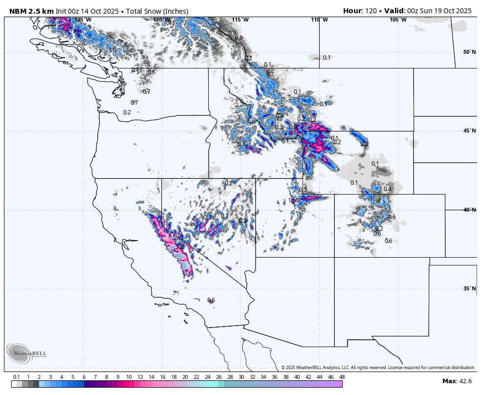
An October cold-core low spins across the West and flips the switch for the season’s first legit mountain snows. Tahoe gets the headline burst Tuesday night into Wednesday with widespread 7 to 16 inches along the crest and solid base-area coverage as snow levels drop. Mammoth piles on roughly 10 to 13 inches through Wednesday morning, with the lightest snow Tuesday night. The Wasatch turns on Wednesday night into Thursday with 4-9 inches in the Cottonwoods and colder, fluffier density. Grand Targhee joins the party with 5 to 10 inches by Thursday night. Resorts are not open, so treat this as a hype check and an early look at who banks the deepest base-building snow. There is still uncertainty in snow totals, especially in the Rockies, with models flip-flopping.
Key Points
Good. Colder air lowers snow levels to near 6 to 7 thousand feet in the Sierra on Tuesday night, then near 7 thousand feet in northern Utah by Wednesday night. Snow-to-liquid ratios trend higher in Utah on Wednesday night and Thursday, so Cottonwoods powder will feel lighter. Winds ease in Utah by Thursday and remain relatively light in the Tetons, helping quality.
Bad. Daytime Tuesday in Tahoe is warmer with denser snow and higher snow levels, then ridge-top gusts Tuesday night can drift exposed terrain. Early Wednesday in Utah starts higher with respect to the snow level before a step-down after the front. Friday brings little more than a cosmetic refresh in most zones.
Wildcards. Forecast discussions from Reno and Sacramento note track uncertainty with the closed low, which could shift the Tahoe bullseye slightly north or south. The models on Tuesday morning shift most of the action focused south. Salt Lake City highlights strong prefrontal winds on Tuesday before the colder air arrives, which could delay lower-elevation stick until Wednesday night. Northern Rockies offices mention a possible “Yellowstone low” wobble midweek that can nudge bands east or west.
Region-by-Region Details

California Sierra
A winter headline pattern is in place through early Wednesday. The heaviest burst focuses Tuesday night, when snow levels fall to near 6 to 6.5 thousand feet and moderate-density snow stacks fast. Projected totals:
- Mt Rose around 5 to 10 inches.
- Heavenly, around 5- to 10 inches.
- Kirkwood around 8 to 11 inches.
- Palisades Tahoe around 6 to 10 inches.
- Sugar Bowl around 5 to 8 inches.
- Northstar around 7 to 9 inches.
- Mammoth: 9-15 inches
Expect ridge gusts peaking in the 20s to 30s mph at times, with the best snow quality where wind shelter exists.
Mammoth spreads its snow more evenly from Monday night through Tuesday night, with the lightest flakes Tuesday night, totaling 10 to 13 inches by Wednesday morning. Winds stay on the lighter side.

Utah Wasatch
A Pacific front and deepening low bring wind, then colder air and better snow density. Snow levels start high Wednesday, then settle near 7 thousand feet on Wednesday night into Thursday. This is the prime window for base-building snow. The models were very bullish on Monday (9-15 inches) but backed down on Tuesday. There is still a chance that we will exceed our forecast below. NW winds behind the front could spell some surprise upside.
- Alta around 6 to 9 inches with rising fluff factor Wednesday night into Thursday.
- Snowbird around 4 to 8 inches.
- Brighton around 4- to 8 inches.
- Solitude around 3 to 6 inches.
- Park City around 2 to 5 inches with best coverage up high.
- Deer Valley around 1 to 3 inches.
- Powder Mountain around 4 to 6 inches.
- Eagle Point around 4 to 6 inches as snow levels stair-step down through Wednesday night.
Prefrontal winds peak Tuesday, then ease into Thursday, improving preservation on leeward aspects.

Northern Rockies
An unsettled midweek pattern favors the Tetons and southwest Montana as snow levels hover near 7 to 7.5 thousand feet, trending lower late. The Storm might skirt just east of the Tetons with a bit more snow in the Wind River or Absaroka ranges.
- Grand Targhee around 7 to 9 inches Wednesday night through Thursday night, with light winds and cold temperatures supporting quality up high.
- Big Sky around 6 to 9 inches spread from Tuesday night through Thursday night, improving as temps fall.
- Jackson Hole around 3 to 5 inches, favoring upper elevations.
- Bridger Bowl around 3 to 5 inches across two waves, mainly on the ridges and higher bowls.
Extended Outlook
A short lull follows. Ensemble guidance and CPC outlooks favor a reloaded storm track into the northern Great Basin and Northern Rockies in the 6 to 10 day period, with cooler than normal temperatures in the West and above-normal precipitation chances. Another system late weekend or early next week could extend early-season base building, especially from the Pacific Northwest into the Northern Rockies.
ANNOUNCEMENT: All of our Concierge Packages are on sale (Custom chase planning to nail the deepest powder) until the end of October. Buy a package now and save up to $100. Check out our new long-sleeve shirts that just arrived and are on sale this month. Buy a long-sleeve shirt and we will throw in stickers for free.
Please support Powderchasers with a donation here.
We support the powder community with these free forecasts.


