There are many things going on right now in the Powderchasers Weather Center.
Highlights: Storm #1- Moderate snow for Montana- Southern Panhandle of Idaho and the Cascades this weekend.
Storm #2 More snow for the Cascades with high end moderate amounts for areas of the Rockies early next week.
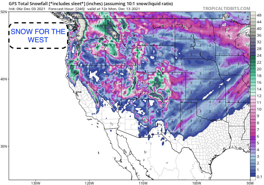
Storm #3. Heavy snow for the Cascades, dropping south over the Sierra and pushing from S-North over the Rockies. 1-3 Feet!
Announcement: Our trusted Heli partner- Alaska Backcountry Guides has only 3 available weeks left for Heli Skiing this year. March-6 to March 26th. Powderchasers is giving away a Free mid level Powder Concierge Package as a promotion for anyone that books with them and mentions powderchasers. This is our #1 pick for great service and powder in the Valdez Ranges. These weeks won't last long.
Lets recap the past 3 days in case you missed it, deep powder was found in Canada with primarily an all snow event for Alberta with Banff Sunshine, and Lake Louise scored deep freshies with almost 100% of the terrain open. Luke from our forecast team chased this storm and has been riding deep powder for the past 3 days. Join our Concierge program if you love power and never want to miss a storm.
Below: Todays snow report from Lake Louise Ski Area in Canada- 123 CM in the past 7 days.

The short term forecast will feature cooler temps to finally return to the Northwest and northern Rockies this weekend. Snow will be falling over the Cascades under a West, NW flow. This will push moisture into Washington State but might favor areas from Stevens Pass to Crystal on Saturday. Some models show a foot of snow for these areas (I-90 resorts, Stevens might be favored). Areas north towards Mt Baker will see lower amounts. Areas of northern Idaho (Selkirk Powder Guides) will also see some light snow with heavier amounts into the southern Panhandle and Montana border. If resorts were open we would be chasing to the PNW.
In Montana moderate snow will be likely for the western portions of Glacier National Park and perhaps Whitefish Ski area on Saturday. Moderate snow near the Idaho southern Panhandle will also trickle into Missoula and Montana Snowbowl (Lighter amounts) this weekend.
Storm #2
In the Rockies snowfall will focus on the Tetons, Wasatch, southern Montana (Big Sky), and Colorado in the Monday PM to Tuesday timeframe. Models show generally 5-10 inches above 7000 feet. It's not a cold system but is cool enough to bring light snow to lower elevations including the Jackson Valley, Park City, and perhaps the higher benches around Salt Lake City. Higher elevations of the Tetons and Wasatch will likely grab 7-10 inches by Tuesday. SW winds might favor JHMR over Targhee or the summit of Teton Pass. In Utah we are a bit more optimistic for Big Cottonwood or even the northern Wasatch (Snowbasin) but overall numbers at higher elevations might be close. Bottom Line: Moderate event, cooler temps, some surprises possible in northern Utah or perhaps the summit of Teton Pass.
Below: This map seems reasonable for the Alta Ski Area (8-10 inches) for peak snowfall Monday night into Tuesday. The next storm will crank heavier amounts towards the end of next week with a jump in totals (Addressed later in the forecast).

Meanwhile in Colorado leftovers will be favoring areas on the western side of the State including Steamboat and areas south towards Aspen and the northern San Juan Range including Crested Butte. SW winds are not ideal for much of the I-70 corridor. Some snow will be falling but lighter than its neighbors further west or north near Rabbit Ears Pass. Bottom Line: Light to moderate event with a few higher amounts in the central or southern mountain ranges.
The Long Range Forecast looks promising:
The models show storm #3 bringing in much colder temperatures and heavy snowfall for many areas. We are very bullish for the Cascades where snow will push south over the Sierra and eventually over many areas of the Rockies. The path of this low will likely drop south and bring the first snowfall to our partner Arizona Snowbowl. Snow will be falling, heavy at times in the San Juan Range pushing north overspreading areas of Utah, Colorado and Wyoming (Tetons may see moderate snowfall).The highest totals may exceed 2 feet in some areas of the San Juan Ranges, extending into the central regions of Colorado. Moderate to heavy snow may also work north into the I-70 corridor with some model discrepancy on how far north the peak moisture pushes. In Utah moisture will push north and overspread the Wasatch with a decent chance of heavy snowfall. CAVEAT: We are still 6-7 days away with model confidence moderate.
Below: Very cold temps at 10K feet overspreading the west next week. Map is from Late Thursday to early Saturday (Temp C). You can see a wide area of the Rockies and southern San Juan Ranges all impacted by this cold front.

Below: The Canadian Models pushes the heaviest snowfall in Colorado south and west with less snow for the Front Range resorts.

Below: The American GFS provides a more bullish solution for much of Colorado (Further north) however SW winds are likely to keep the highest amounts in the San Juan and central mountain ranges. Models will change as we get closer. NW flow behind the front could help the I-70 corridor.

Below: The Sierra ranges could finally score a foot or more powder late next week.

Bottom Line: The storm late next week is likely to be a very good snow producer and has very cold temperatures.
Please follow my adventure on Instagram @powderchasersteve for photography, wildlife, travel and of course snow!
Enjoy the powder everyone! Powderchaser Steve


