
SUMMARY:
Models are in synch for some very big snowfall totals for the Pacific Northwest and most of western BC in the next 5 days. The Sierra nabs 5-10 while the Central and southern Rockies score 11-18 or more!
If you want to chase powder and nab the deepest days of the season (We have already scored several), join our concierge for custom forecasts, access to our forecasters, and a newsletter exclusive to members. Join Here.
This post is sponsored by The Tire Rack and Arizona Snowbowlwho support Powderchasers. We do not chase without our Winter specific tires from the Tire Rack especially if you want first chair. Any wheel and tire packages purchased from our site will enable you a free concierge forecast. Snow will finally be falling over Arizona Snowbowl this week!
FORECAST:
PNW, Canada, Sierra
In looking at data on Tuesday morning, high confidence exists for game changing snowfall for the Cascades, especially in Washington where 3-4 feet could fall by Saturday (Favored locations will include Snoqualmie Pass, Alpental, Stevens, followed by Baker). West Northwest Flow will crank precipitation likely closing I-90 and Stevens at some point Thursday or Friday (Be aware of road closures). There is a long progression of moisture that all begins on Wednesday and continues heavy at times especially late Thursday to Saturday. Snow will move south over the southern regions of Washington for the Thursday-Saturday timeframe with lower but respectable totals of 12-20 inches for Crystal and ares south into northern and central Oregon. As mentioned areas north towards I-90 will see 20-30 inches or more!
Bottom Line: The PNW will get crushed in the next 5 days. Western BC will not be far behind with feet of snow being measured at Whistler. Chases might be worth it. Resorts in the Cascades will likely open after this storm.
Moisture digs into the remainder of the west Thursday-Friday with the Sierra looking at a moderate event of 5-10 inches. The models show higher amounts are likely in the central or southern regions of Tahoe extending to Mammoth who might see higher amounts. I am happy to see some snow for the Sierra once again, but they still need several 1-2 foot dumps before its worth a chase.
Below: Total snowfall from Tuesday to Saturday (Mega Deep amounts). Get ready for openings.

Rockies
In the Rockies, the core of the low pressure digs over western Nevada (Ruby Mountains), and extends from the entire Wasatch Range of Utah through to the 4 corners peaking Thursday mid morning to Friday morning. Winds start from the SW (Snow levels will start out a bit high) but crash to the valley floors mid Thursday with a continued NW flow, lake enhancement and colder temps with the front(Right side up snow). Snow will continue Thursday night before tapering in most locations outside the Cottonwoods. Unstable NW flow will bring lake enhanced snow to areas south of the Great Salt Lake Friday morning with the Time Heights advertising that some snow showers will continue over north/central Utah into Friday night albeit lighter intensity. Currently from looking at model data, our forecast is for 8-12 inches from the Ogden resorts (Powder Mountain is favored in this flow), 6-12 inches for Park City (Higher amounts on the Canyons side) and 12-18 for the Cottonwood Canyons. It's possible that by Friday afternoon totals exceed 20 inches if the lake kicks in and cold unstable NW flow continues. Be sure to grab your wheel/tires from Tire Rack.
Below: Time heights humidity and moisture for Alta peaking at 6Z Thursday (Midnight Wednesday) to late Thursday (Friday 0Z). Winds are westerly before shifting to the NW early Thursday morning. Cool unstable flow is noted into Friday under NW winds (Slight break late Thursday with snow showers continuing into Friday. Snow levels are lowering with the blue line by Thursday mid morning and crash below 4800 feet by Friday morning. Atmosphere stays slightly unstable into Friday night.

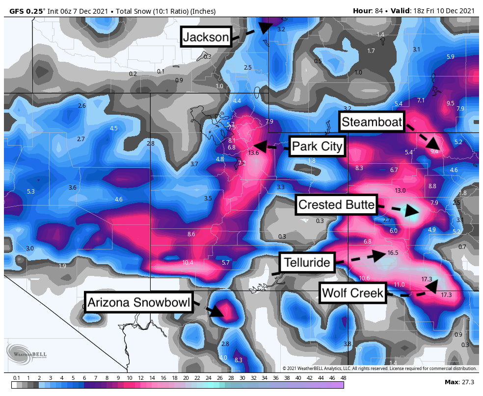
In Colorado, snow will be heavy at times Thursday into Friday favoring a wide area of western Colorado. As I mentioned on several forecasts earlier the highest storm totals of 14-20 inches are likely in the central or southern mountains (Liking the odds of deep dumps for Crested Butte, Telluride, Purgatory, Wolf Creek, with Steamboat and Monarch a solid wildcard. While moisture is more limited further east, the winds from the NW should still allow the I-70 corridor to grab 5-10 inches especially Vail Pass, Beaver Creek (Does well with the initial westerly winds), and perhaps Breckenridge (High elevations surprises). Friday will be a deep powder day in some locations but remember you are dealing with very limited bases right now. I am not sure I would chase?
Below: Total snowfall from Tuesday to Friday morning. Many areas grab decent freshies, with the highest amounts in central or southern Colorado, Wasatch Range of Utah, southern Utah, and even happy to see decent snow for Arizona Snowbowl. With cold temps these amounts will likely exceed the maps (Better snow ratios), so even with 4-6 inches in some areas on the map it will likely be higher (Summit County). Cold temps will bring Valley Snow to most locations by late Thursday.

There is a lot to talk about! Hey, if you like reading this forecast, follow me on Instagram for adventure @powderchasersteve
Enjoy the new snow everyone!
Powderchaser Steve


