As the weather cools and the days grow shorter, thoughts turn to skiing. Ski season is just around the corner, and excitement is building. The snow is starting to fall in the mountains, and the slopes are calling. It’s time to break down some of the atmospheric factors that may make or break your season.
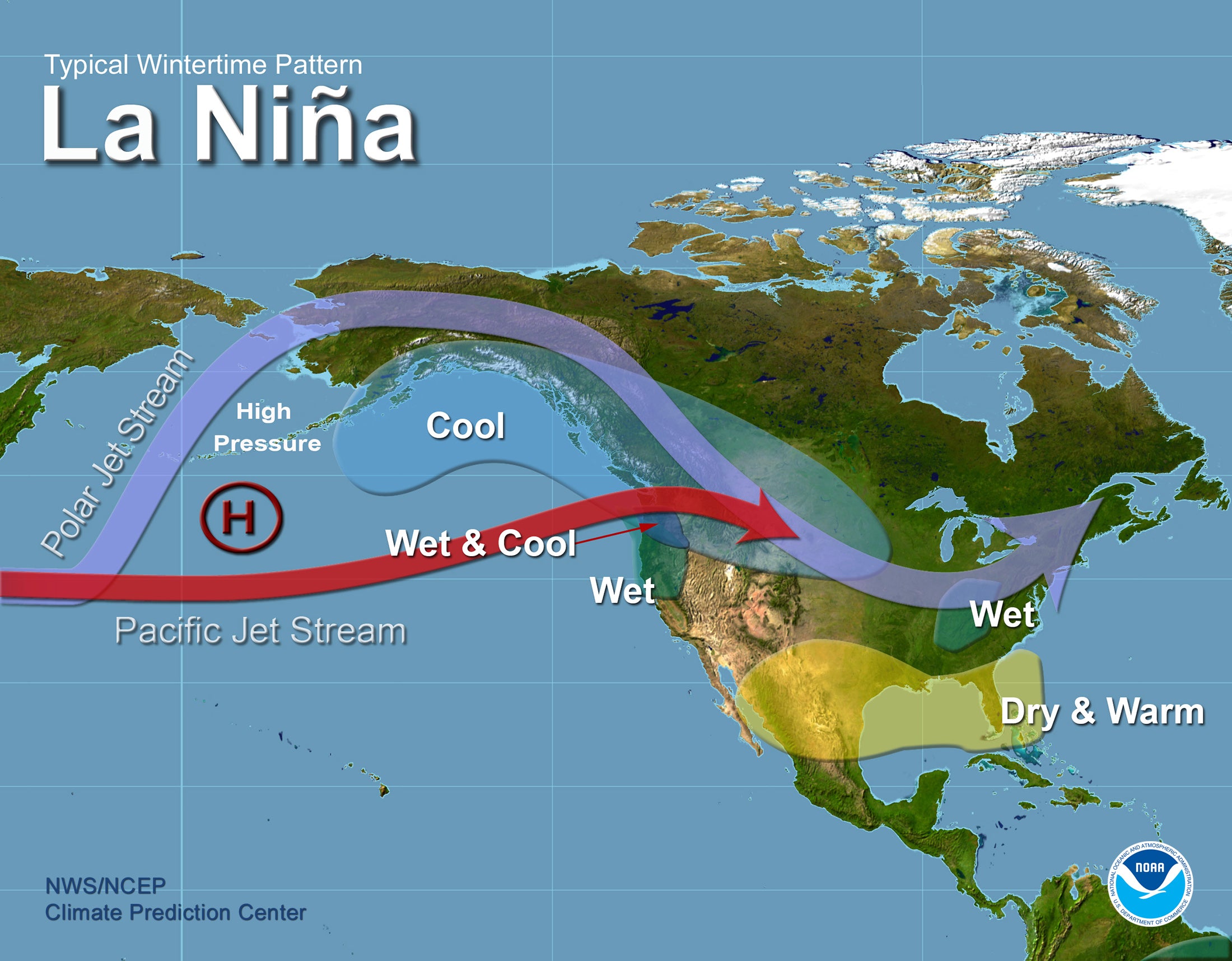
The first and most obvious factor is the current El Niño Southern Oscillation (ENSO) phase. We’re in a robust La Niña phase (negative ENSO) of about -1C, which classifies this year as a strong La Niña year. However, the latest modeling projects the ENSO to dip even further negative all the way to nearly -1.5C in November before rebounding and warming again.

Understanding how the ENSO affects North American weather is all about understanding the jet stream. The jet stream is a band of strong wind speeds that separates polar air from tropical air. The jet stream essentially contains storm systems to its north and keeps high pressure to its south. That’s why we refer to these systems as ridges (where the jet stream bends northward and forms a “ridge”) and troughs (where the jet stream bends to the south and forms a “trough”). ENSO affects the jet stream, which is the main way it influences North American weather systems. A positive ENSO phase (El Niño) causes a more consistent jet stream with a fork in the jet stream over the pacific, keeping the Pacific Northwest drier and bringing additional moisture to California. A La Niña ENSO phase does the opposite; it increases the volatility of the jet stream, creating what’s called “meridional flow.” Meridional flow occurs when the jet stream becomes “wavier” and runs more north-to-south, allowing for more favorable conditions for strong storms and moisture in the Pacific Northwest.

Going into the 2022-2023 season, it would appear at face value that the Pacific Northwest would be strongly favored and that California and Utah, placed further south, would receive below-average precipitation. However, there is more nuance than just that. Very strong La Niña years can create favorable conditions for particularly strong storm systems; ones that reach all the way down to California and bring snowfall. This phenomenon was in full effect the last time we had an ENSO phase this strongly negative in 2010-2011; nearly every watershed in the Western US ended up with above-average precipitation.

Fortunately, the ENSO phase is not the only factor that influences our winters. Some other teleconnections that are crucially important include the Pacific Decadal and Quasi-Biennial Oscillations. The PDO is currently strongly negative, which is favorable for the Western US and unfavorable for the East Coast.

Above is the effect of a positive PDO on 500mb geopotential heights (a rough approximation for storminess). The inverse will be true this season, where geopotential heights will be lower in the West and higher in the East.
The QBO is currently exiting a roughly year-long negative phase and is beginning to shift positive again. The last year this occurred was during the fall of 2018, right before the massive 2019 season. And before that? Fall of 2010, also a massive year for the Western US. Generally speaking, a positive QBO is beneficial for Western US and is fairly neutral for the East Coast. Below is a positive QBO phase's effect on precipitation.

Finally, one additional interesting factor, pointed out by Joe Daleo from WeatherBell, is that both 2022 and 2010 were exiting periods of solar minimums. Once again, this was directly before a record-breaking season in the Western US.
All things considered, things are shaping up to be quite favorable for the Western US and neutral to just below average in the East. The most snow-sure areas will be found in the Pacific Northwest and will extend to the southeast into Northern Utah, Wyoming, and northern Colorado. California will be boom or bust; it remains to be seen whether the strong negative ENSO phase will keep the jet focused in the PNW or whether the increased volatility is able to bring stronger systems into California. In the case of the former, the PDO and QBO may be able to offset ENSO’s influence and keep California near average.
Winter Tire Announcement: Save up to $100 on a set of winter tires from the Tire Rack by linking here through September 26th. Limited promotion ends soon and allows you to be ready as storms are already hitting upper elevations. This promo applies to many top brands!
Below: Stoke was high last week with a quick tease of snow-covered roads in northern Wyoming.

Fingers crossed for a deep season ahead!
Stoke Alert: Some models are hinting at a decent cold front and some snow for western BC, and Alberta pushing south through the Rockies by mid-next week. The Canadian Models are bullish while the GFS and European are a bit less. We will watch to see if it materializes.
Powderchasers is looking for additional sponsors to support us for the 22/23 season. Please reach out to us at powderchasers1@gmail.com if you would like to be featured in future posts. We are also looking for interns for social media and forecasters with a great powder attitude that want to work in the Ski Industry.


