Powderchasers is tracking 2 storms that will bring decent snowfall to mid and upper elevations to many ski areas in British Columbia, the Pacific Northwest, and a wide area of the Rockies beginning Friday and continuing into much of the following week. Confidence is high for a pattern change, much colder temps, and the timing of these storms. Amounts are likely to be decent above 4,000 feet through early next week but how much, and who sees the highest amounts is still outside our highest confidence window. There is a long duration of snowfall with 2 main systems impacting the west from this weekend into the middle of the following week.
Storm #1 will impact the Northwest as early as Friday night with moderate amounts above 4,000 feet. This moves into the Rockies for the weekend.
If you are mountain biking fall foliage out west like some of our crew was yesterday things will look much different beginning later this week. Get your fill of foliage this week before it disappears by the weekend.
Below: @powderchasersteve mountain biking some brilliant colors in Park City on Sunday on his Ibis Ripley.

Low pressure will begin to impact many areas of Canada by late this week and overspread the Pacific Northwest and northern Idaho by late Friday. The European model is pretty bullish for decent amounts by late Saturday (6-12) whereas the American GFS and Canadian are showing lower amounts (3-7). This overspreads northern and central Idaho, Montana, Wyoming, Utah, and Colorado from late Saturday to Monday. There is model divergence on who sees the highest amounts with our confidence a bit better for the panhandle of Idaho, Central or southern Montana, and Colorado. The Tetons and Wasatch are solid wildcards, especially Utah where strong SW winds early in the storm migrate to NW and might kick in some good post-frontal precipitation. Colorado will likely do well-favoring areas west of the Divide and extending into the central and even southern mountains later this weekend.
Bottom Line: Much lower temps this weekend, snowfall for a wide area of the Rockies and PNW with some model divergence on amounts. It’s likely that our Powder Alert Criteria of 12 inches or more is met by Monday, especially in the Rockies. A convergence zone (Cold air with west, NW flow) might set up over the central Cascades at some point this weekend enhancing snow totals).
Below: The climate prediction center outlook from October 16-24th looks wetter than average in many areas of the west.

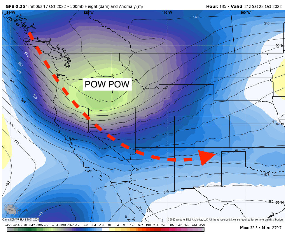
Below: Low pressure has extended well into the PNW and Rockies by late Saturday. This will favor the Pacific Northwest and a good area of the Rockies by the weekend. Image: Weather Bell

Below: Sharp cold front dropping temps to -10 C (14F) in many areas shown at 10K feet. Temps will be near freezing at pass levels in Washington and well below for most of the Rockies. Cold air will increase snow-to-liquid ratios so there is a chance that these storms over-perform especially at the mid or upper elevations. Image: Weather Bell

Below: The American GFS depicting moderate snow for a wide area of the PNW and the Rockies through Monday next week. The European was a bit more bullish while the Canadian was less. Northern areas of the PNW including Idaho may do well extending into Montana, Wyoming, Utah, and Colorado. Some areas are likely to see a foot or more at the higher elevations, especially in the Rockies through Sunday night. Keep reading for storm #2

STORM #2
A second storm impacts the west in week 2 (October 24). This system will bring additional snowfall to many areas of the west. It’s likely that additional snow will fall in the Pacific Northwest and a wide area of the Rockies again next week (October 24-28). That storm may eventually edge a bit further south or west and bring a higher chance of snow for the Sierra at some point however it’s too far out to forecast with accuracy.
Below: Low pressure is depicted over the west with storm #2 impacting the region in the October 24th-28th timeframe). Temps should stay cold enough for some lower-elevation snowfall in many areas (Unsettled pattern). We will update snow totals and track in a future post.

Announcement: Please support our sponsors! Our long-time sponsor Selkirk Powder in northern Idaho may fare well with this storm. Tire Rack can provide you an opportunity for winter tires shipped to your home in 24 hours (*We only chase with snow tires) here. Special shout out to Beaver Mountain in Utah who has been our longest-supporting sponsor. Please support family-run ski areas and check them out this season if you are chasing to Utah.
Please sign up for our free powder alerts on our website (Powderchasers.com) and support us by joining the powder concierge. that almost assures you of deep powder. Or if you just simply love reading our powder forecasts send us a donation to support our team.
Forecaster: @powderchasersteve - Powderchasers.com


