As of June 2023, El Niño conditions have developed, with the atmospheric response to the warmer-than-average tropical Pacific sea surface kicking in over the past month. The El Niño phenomenon is expected to continue into the winter, with a high probability (56%) of becoming a strong event at its peak and an even higher chance (84%) of at least a moderate event. The monthly Niño-3.4 index, which measures the temperature of the surface of the tropical Pacific ocean, was 0.5 °Celsius (0.9 ˚Fahrenheit) above the long-term average, indicating that we are indeed in an El Niño phase. This anomaly is anticipated to remain above the El Niño threshold for the next several months, based on climate model predictions and current conditions in the tropical Pacific.

Above: CFS ensemble forecast of the current and projected ENSO conditions. Note the high-confidence in a moderate-strong El Niño for the 2023-2024 winter.
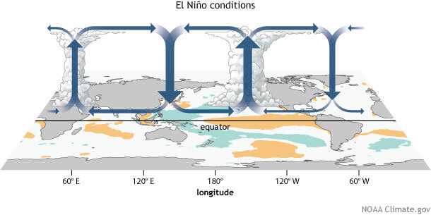
El Niño conditions lead to changes in global atmospheric circulation, which in turn influence weather and climate patterns. One crucial component of this is the Walker circulation, an atmospheric pattern over the equatorial Pacific. During El Niño, warmer-than-average surface water alters this circulation, bringing more rainfall and convection to the central and eastern Pacific. The trade winds weaken, which allows the surface to warm further, and this is a critical feedback mechanism indicative of El Niño. Evidence of a weakened Walker circulation over the past month has been observed, with weaker trade winds over the western Pacific and more clouds and rain over the equatorial Pacific.

For the United States, the onset of El Niño triggers changes in tropical rainfall and wind patterns that reverberate globally.
The most significant impact is a shift in the path of the mid-latitude jet streams.
These high-level winds play a critical role in separating warm and cool air masses and steering storms from the Pacific across the U.S. During El Niño, the deviations in weather patterns are not exactly the same as during La Niña, but they are somewhat reversed. However, the influence of El Niño on U.S. winter climate is a matter of probability, not certainty, and every event is somewhat different.
These shifts in atmospheric circulation patterns can have significant impacts on the upcoming ski season in North America. Understanding that it is still early and conditions could change by the time winter arrives, we can make some educated predictions based on the current El Niño conditions.
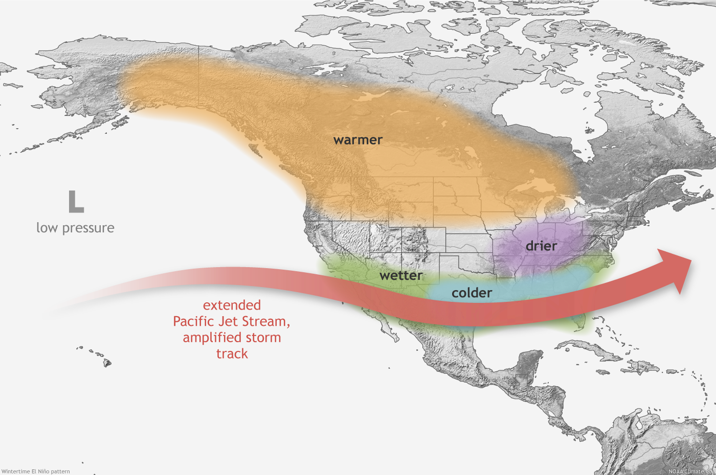
Typically, El Niño winters are associated with a more southerly storm track across the United States. This happens because the jet stream, a band of high-speed winds in the upper levels of the atmosphere, is influenced by the shift in location of tropical rainfall caused by El Niño. This results in the jet stream taking a more southerly route across North America, steering storms from the Pacific Ocean into the southern states.

Above: El Niño effects on the Pacific jet stream. Note the wetter and cooler conditions further south.
If the El Niño continues to strengthen as currently predicted, ski resorts in the southern Rockies (e.g., New Mexico, Arizona, southern Colorado and Utah) and the Southeast (e.g., North Carolina) could see above-average snowfall due to the more southerly storm track. Resorts in Southern California could also benefit from increased precipitation, which could translate into improved snow conditions. Areas of the central Rockies including the core of Utah and even central or northern Colorado resorts are not has heavily impacted sitting in the middle of these weather patterns.

Above: El Niño's effect on storminess (cooler colors = stormier, warmer colors = drier).
In contrast, ski resorts in the northern Rockies and the Pacific Northwest might experience below-average snowfall due to the jet stream's altered path. It's important to note that while the overall trend might be for less snow in these regions, it doesn't mean they won't have significant snowfall events throughout the winter.
The influence of El Niño on winter weather isn't limited to the United States. In Canada, the impacts of El Niño can be quite variable. However, ski resorts in British Columbia and Alberta could experience milder and drier conditions than usual, potentially leading to less snowfall.
El Niño winters can occasionally lead to more significant snowfall in the Pacific Northwest and Northern Rockies, although this is less common. These anomalies can occur due to the complex interplay of various weather patterns, and not all El Niño events are identical. For instance, during the 2015-2016 winter, an El Niño event led to above-average snowfall in these regions. However, it's important to note that this is not the typical pattern and other factors can influence these outcomes. The influence of El Niño on U.S. winter climate is a matter of probability, not certainty. In general, while we can make educated predictions based on past patterns and current conditions, weather is inherently unpredictable and can vary widely from year to year.
Remember, these are generalized effects and every El Niño event is somewhat different. Additionally, many other factors influence winter weather, and the strength and timing of El Niño can affect its impacts. So, while we can make some educated predictions based on the current conditions, it's important to keep an eye on the weather forecasts as the ski season approaches.
Stay tuned with Powderchasers for updates. If you are interested in becoming a sponsor and reaching over 3 million skiers per season please reach out to us at powderchasersmedia@gmail.com We rely on sponsors to support our forecasts. Sign up for our Concierge program and browse our MERCH on the new store.
Powderchasers Forecast Team


