
Pacific Northwest: Looking at the models this morning, confidence is still good for some significant snow above 5500 feet this week in the Northwest including Whistler. Several systems are moving ashore with warm temps initially (Snow levels 6-7K) before slowly dropping to 4,000 feet this weekend. Winds from the SW initially will feed higher amounts into the northern Cascades (Mount Baker) that could see moderate amounts at the summit as early as Friday (Rain at the base).
Further south, towards Stevens, Snoqualmie and Crystal things will get more active later this week into the weekend as winds shift to the west and northwest. Temps will bring snow to the bases by Saturday morning. Its possible that 12-20 inches fall at the summits in some resort locations (Weekly totals) with much less at lower elevations. Higher amounts are possible through the beginning of next week as a final wave moves in with additional light or moderate amounts. Whistler this week should see slightly cooler temperatures with decent totals at the summit and mostly mixed or rain at mid mountain. Further South into Oregon should nab moderate snowfall especially late this week.
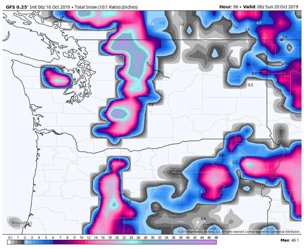
Below: Impressive snow totals on the GFS through Sunday for the PNW including BC, WA and even Oregon. Its possible these high ranges land only at the summits or peaks surrounding the ski areas so trending my numbers down slightly (10-20 at the summits).

Bottom Line: Rain/mixed snow, teases the NW initially this week before cranking up late Friday-Saturday with slight cooler temps and better snow levels. Best day to find powder may be at upper elevations on Saturday morning.
Rockies: The first wave moves into most of the mountains of Idaho, Wyoming and Colorado by Friday. That system is weak, purely a tease that might land 1-3 inches in many areas. Cooler and wetter conditions move into Idaho (Brundage might score) Saturday with things ramping up late for Wyoming (Tetons). Late Saturday night or early Sunday morning sees the most significant snow for Utah and Colorado with favorable wind directions for many mountains receiving a moderate dump (4-10). The higher amounts on this range is likely in the northern Wasatch or the Tetons above 7,000 feet. Colorado is a bit of a wildcard at this point for Sunday morning with decent orographics (NW winds) but a fast mover that is likely to land 3-7 additional inches favoring the northern and central mountains (Monarch might be in the wildcard range).
Powderchaser Steve


