
SUMMARY:
Im fired up this morning, once again living a dream that by the weekend we can chase powder! Actually Keystone and A-Basin are open so it's possible that Sunday morning delivers your first face shot of the season (A bit of a stretch of wishful thinking). It will be snowing heavily in areas of the central and southern Cascades late this week that transitions to ID, MT, WY, UT, and Colorado for the weekend. There are 2 systems, the 1st being relatively weak and the 2nd stronger for the weekend. Sunday is likely to be a powder day in many spots of the Rockies.
It's currently snowing lightly in the Northwest with fairly high snow levels (4500-5,000). Looking at webcams it appears Whistler may have scored some decent amounts at upper elevations. There is light snow falling elsewhere which will increase Thursday night-Saturday with a cooling trend.
Below: Whistler Mountain - 6,000 feet (Below the summit).

In Washington I am not seeing much new snow on automated telemetry but would not surprised to see some white on the peaks from the past few days. The first wave in the PNW moves in late tonight and Friday morning (3-6) with another colder and deeper system for Friday night/Saturday (5-10). Total snowfall will range from 8-16 additional inches through Saturday afternoon. NW and West wind directions may favor areas from Stevens Pass south to Crystal Mountain. A convergence zone (Westerly Flow with cold air) is possible for the I-90 resorts (Alpental, Snoqualmie) and Stevens Friday night. Chase for Saturday! Significant snow is also likely for the central and northern Cascades of Oregon (Bachelor, Timberline).
OVER 100 INCHES FOR THE MOUNT BAKER SUMMIT (OUTSIDE THE SKI AREA- 10K) IN 5 DAYS
If you add up the total snowfall expected for Mount Baker at 10,000 feet (East of the Ski area at higher elevation) its always exciting to see a NOAA forecast like this! Thats over 100 inches in 5 days! WOO HOO

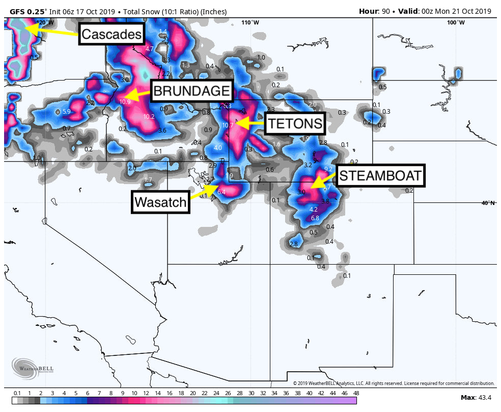
For the Rockies the first storm moves in late Thursday/Friday. It's pretty weak with light amounts for the Tetons, central Idaho, northern Utah and most of north/central Colorado. Its purely a tease of 2-4 inches for many of these areas so let's move on to the weekend.
Models are in good consensus of 8-12 inches Saturday/Sunday for the Tetons (Targhee may be slightly favored due to NW wind direction) Central Idaho, Wasatch and northern Colorado (I-70- North likely to see the highest amounts). Its likely that some surprise totals of 10-16 inches occur due to a favorable NW wind direction (Orographics are good for the Cottonwoods in Utah, Steamboat, and Snowmass). Peak snowfall will happen midday Saturday-Sunday in Idaho and Wyoming, and primarily late Saturday night into Sunday for Utah and Colorado. Snow showers will linger during the day Sunday keeping conditions soft especially in Colorado where light snow will be falling.
Below: University of Utah plumes (NAEFS) for Vail Pass showing totals of all ensemble runs with the solid lines the predictive average. The mean is around 6-8 inches however higher amounts are possible with orographics.

Below: Same info as above for Crystal Mountain Washington (10 or more inches).

Below: Finally the Plumes for the upper elevations around Steamboat (Showing up to 20 inches).
.png%5C%22)
Here is a look at the total snowfall for the West through Sunday courtesy of Weatherbell. Many areas of the west score this weekend!
.png%5C%22)
Please support our sponsors and sign up for our powder concierge program. Get your snow tires on!
Powderchaser Steve


