Summary
The place to be right now would be Stevens Pass with 15 inches of blower overnight, and 22 inches in 24 hours. The week ahead might be really good, especially for the Rockies
Forecast
Chase of the day! 47 inches for Stevens Pass in 7 days! Convergence zones set up last night with a cold westerly flow providing what will be epic turns today for central Washington. Further South towards Alpental had less snow, but still respectable. On Super Bowl Sunday some folks might elect to keep skiing, as snow showers continue all day for the central Cascades. The Convergence zones are likely to drop south towards I-90 enhancing snow totals for Snoqualmie Pass through Sunday evening (Ride all day Sunday and early Monday). Sunday will be deep and it might repeat further south for Monday.
Montana also got hammered with 24 inches at Lost Trail (MT, ID border) and up to 14 inches (Summit) at Montana Snowbowl in Montana. Some of that snow fell on Saturday.
Elsewhere in the west light snow fell in Colorado with up to 5 inches at Eldora. I mentioned the path favoring Steamboat (Only 3 inches mid mountain last night) and areas east on the last post. Steamboat has seen 25 inches in the past 3 days.
Snow showers and wind continued for the Tetons Saturday/Sunday (9 additional at JHMR) with variable conditions (Chaulk like consistency at the summit) noted yesterday on my first tram lap at Jackson Hole. With the strong winds, its likely that folks skiing in in the Tetons will experience a wide variety of conditions.
EXTENDED
The week looks active for a moderate system pushing into the Rockies by midweek (Utah and Colorado might be favored) with stronger energy noted on the GFS for the Sierra late next week. The energy from California is likely to produce significant snowfall for the Rockies at some point late next week. The track is currently noted to favor the central or southern Rockies bringing decent snow totals to Utah, Colorado, Arizona, and New Mexico. Being this far out, I won't make any specific prediction, other than decent confidence for an active pattern setting up for the west (Sierra storm Thursday/Friday) followed by the Rockies). The midweek system will be a precursor to the stronger systems to follow for late next week.
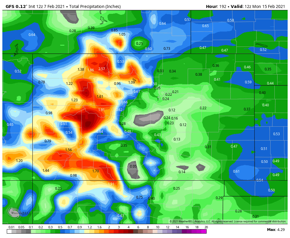
Below: Total liquid precipitation for Colorado through Monday morning (Day 8 in the forecast period). The models are not very accurate this far out, but its likely many resorts will continue to reap good rewards, perhaps with some of the highest amounts coming from the western side of I-70 and areas south. Utah, Arizona, and New Mexico are also in good position.

ANNOUNCEMENT:
With very sad news, my thoughts go out to the families of the 4 skiers that were killed in a major avalanche just outside Salt Lake City. Significant rescue operations were in progress all afternoon (Air Medical),evacuating an additional 4 skiers. Saturday was a very sad day for our backcountry community.
Powderchaser Steve


