Significant pow just crushed the Washington Cascades. The next round of snowfall begins to track into the northern Rockies by Tuesday with a stronger storm likely by Friday/Saturday/Sunday.
ANNOUCEMENT
If you are looking to escape the crowds, love powder, and want a small group Heli experience in Alaska consider these remaining seats at Alaska Backcountry Guides our endorsed partner for Partner. The only seats left are 3/15-3/21 (5 seats) and 4/26-5/2 (4 seats). Powderchasers is giving away a free Concierge Package (Mid level) good for this or next season for anyone that books with Alaska Backcountry Guides.
Forecast
In yesterday's post, the forecast called for the strong convergence zone that set up over Stevens Pass on Sunday (16 inches) would drop south over I-90. This morning in looking at snow telemetry, it's possible that Alpental/Snoqualmie just east of Seattle grabbed 16 inches at upper elevations since the lifts closed Sunday (Unofficial). The telemetry shows snow heights jumped from 11 inches on the stake to 27 inches (Far right). The lower elevations may have only picked up 8 inches. These seem reasonable with the very cold temps, high snow ratios, and significant hourly precipitation mainly from 6PM to Midnight.

6 inches fell further south for Crystal, and another 8-9 inches fell for Stevens Pass who has had over 55 inches in the past week. Stevens kept 2 chairs closed on Sunday (It's become a norm on powder days) so you might get lucky on Monday and score openings.
The upcoming week features decaying leftovers from the PNW to stream over the northern Rockies through Wednesday. Light snow will feature these events Tuesday over the Tetons and Wasatch increasing somewhat over Colorado for Wednesday. Light or moderate snow will freshen up many Ski Areas favoring the northern Rockies through this period (4-7). Colorado may edge out it's neighbors by Wednesday with some areas looking at 5-10 inches (Tuesday/Wednesday totals) favoring the western side of I-70 and areas south towards Aspen and Crested Butte. Steamboat is also likely to score decent amounts midweek. While this system is not strong nor has any single deep event, the sum totals could be respectable especially in isolated areas of Colorado. Read on! The extended could be very deep.
Below: Weak Low pressure noted over the Rockies favoring Wyoming, Utah and Colorado by Tuesday/Wednesday.

EXTENDED:
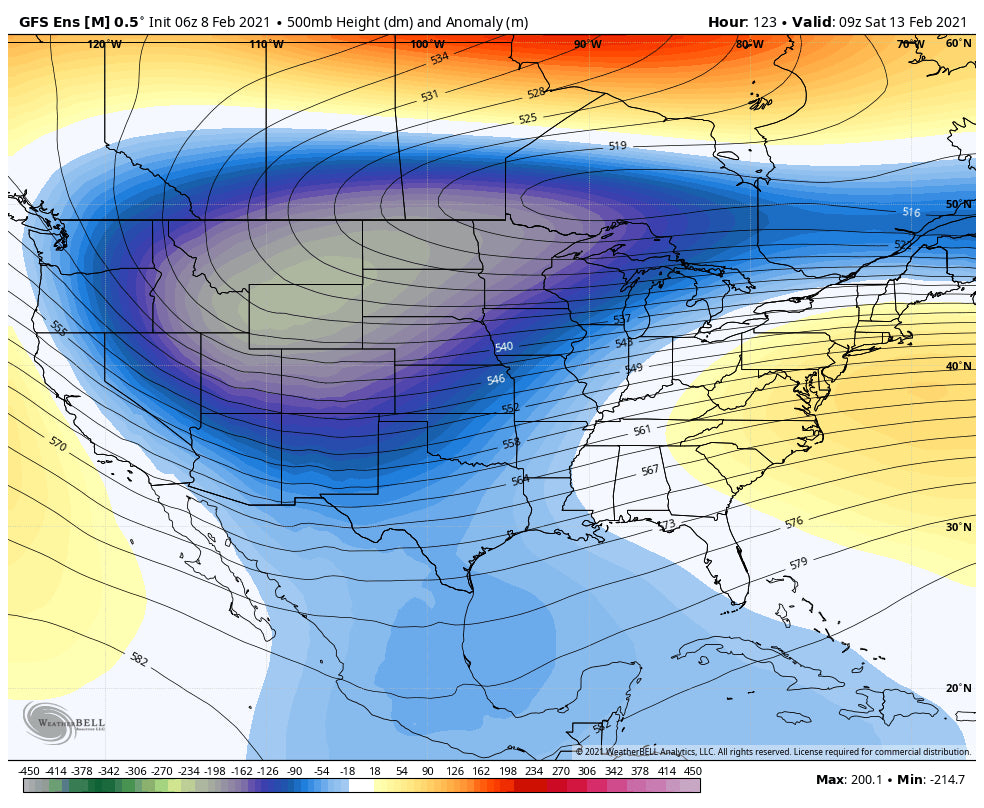
A developing low-pressure system will move into the Pacific Northwest by Thursday. The models disagree with the exact track, some favoring Oregon and others further north over Washington. This system will bring snow to the Sierra as the system drops south before moving east over the Rockies. A sharp cold front moves down from Montana into the central Rockies by the weekend. Significant snow is likely for many areas of the Rocky Mountains. Currently, if things hold up per the ensembles we could be looking at several feet of blower pow just in time for another busy weekend. The American Model brings this storm further south while the European edges it further north (Northern Rockies). Regardless, this should be a very good snow maker to a wide area of the Rockies, with the Sierra a wildcard.
Below: Decent Trough is moving over the Rockies by Friday

Below: Deep low pressure is noted over the Rockies by the weekend.

Below: Very cold air will enhance quality and snow ratios (Higher snow totals) by Friday over Wyoming and Saturday over areas further south (Map is shown for Saturday morning).

Looking further into February, we appear to stay in an active pattern but it's too far out to provide any details.
Below: Seasonal Predictions for the remainder of February indicating above normal precipitation for the northern Rockies and PNW, with near normal for northern areas of Utah and Colorado.

If you want to chase deep powder and want custom forecasting (Best snow, Deepness, best resorts, last minute choices, or advance planning), please join our Concierge program. This program provides the highest level of planning.
Enjoy the Powder Everyone!
Please follow our forecaster @lstone84 on instagram for live action from all the recent chases.
Powderchaser Steve


