Summary: Weak leftovers are approaching the Rockies currently with light snow approaching the Tetons. A sharp cold front has been helpful in bringing some decent amounts to Idaho on Tuesday. A secondary system is impacting the 4 corners albeit weaker. Early December might deliver in the extended forecast.
Announcement: Please consider joining the custom powder concierge program to support Powderchasers and receive very specific chase info this season. Also, with colder temps in the extended outlook its a good idea to have your snow tires ready to go from our winter sponsor The Tire Rack. Bonus for Thanksgiving week: Anyone that purchases a wheel and snow tire package from linking directly from our website will receive 1 free concierge chase forecast this season. Just email us with proof of purchase but remember to link from our site or the Tire Rack
Forecast:
Snow will be falling over the Tetons Tuesday night as a wave of moisture and colder temps moved over Montana and Idaho bringing 3-6 inches of snow to some areas. As of 5 PM Tuesday the snow camera at Tamarack (south of Brundage) had around 6 new (Started at 2 inches before this wave hit).

This band also brought 3-5 inches to Brundage Mountain. This wave will be in the Tetons by 7 PM Tuesday and continue lightly until Wednesday morning. The models and short-term High-Resolution models show 2-4 inches however a sharp cold front will increase the snow ratios (Higher snow totals to moisture). It's possible that 4-6 inches fall over the mid-elevations of the Tetons (1-3 at the base) with higher amounts at the summit.
In Colorado, a weak wave is currently over the 4 corners with light snow currently falling at Telluride. The radar is showing a band pushing north towards Aspen. These waves are not expected to put down more than just a few inches with higher amounts possible at Wolf Creek or further south into New Mexico. Another wave from the north (Currently over Wyoming) and colder temps will graze N-Central Colorado on Wednesday morning with some snow showers (I-70 and perhaps even the Denver Metro sees a few flakes). I would not expect any travel impacts.
Below: The short-term high-resolution model (Good confidence) shows very little moisture through Wednesday morning for Colorado with the exception of 2-4 inches over Wolf Creek. Higher amounts will fall south into north-central New Mexico.

Meanwhile, the Pacific Northwest scored 5-9 inches in the Cascades. Baker, Stevens, Crystal, and even the northern resorts in Oregon (Mt Hood) grabbed similar amounts. Temps were cold so snow fell to the bases. Whistler grabbed similar amounts.
Storm #2
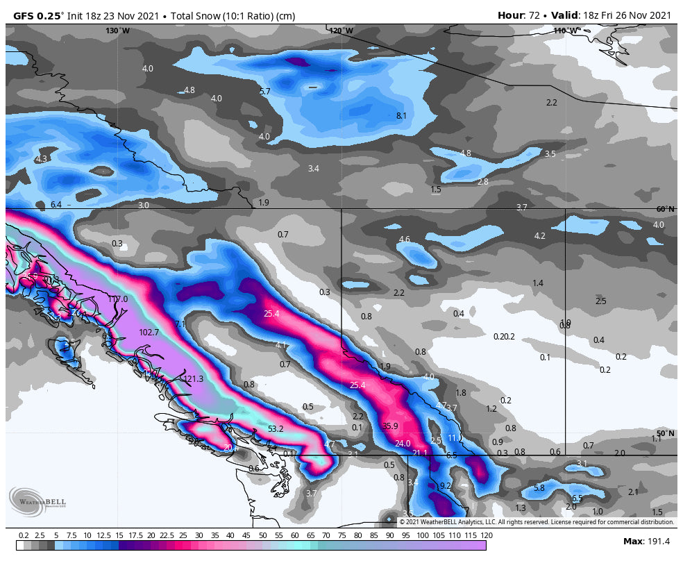
Another stronger wave with an atmospheric river tap- will approach Canada with significant moisture to close out the workweek. Temps will be warming so it's likely mainly rain will be falling at most elevations of the Cascades. Mt Baker snow levels up north should be around 4500 so some high elevation deep snow is possible at the summit. Thursday will see the peak rain/snowfall.
Below: Total snow for the Pacific Northwest and Canada through Friday. Significant snowfall may only fall at the peaks of the western Canadian Resorts of BC, with rain elsewhere. The summit of Mt Baker may also see some decent wet snow. (4500-foot snow level up north with even warmer temps further south). The far northern areas of coastal BC might score with slightly cooler temps through Friday.

The Extended gets exciting especially early December.
Extended POW
Storm #3
The extended forecast brings another atmospheric river into the Pacific Northwest with slightly cooler temps for the weekend. Canada including the interior of BC might pick up a decent dose of snowfall from the mid-elevations to the summits with slightly cooler air. Snow is likely to change to rain even at upper elevations Sunday/Monday as warmer air once again moves over the Northwest including interior BC and coastal ranges.
But wait! We don't like to look out this far in advance specializing in chasing powder, however, the models indicate much colder air will finally approach the west around the December 5th timeframe. This may land some decent snow totals for many areas. The long-range snow models look pretty impressive for many areas from the Cascades, Sierra, and Rockies. The Good: Pattern change is likely with colder temps and snow beginning around December 5. The Caveat: Models that far out will change as we get closer so it's impossible to predict with accuracy. if the cold air moves far enough south areas of California will see a return of some snow.
Below: Low pressure is likely for the December 5 ish timeframe for many areas of the west.

Below: Much colder temps will finally arrive for many areas of the west beginning in the latter part of next week. This cold front should make it further south as the week moves out but we will have to watch it. Temps are C at 10K feet. Map Date:December 5th.

Enjoy the Thanksgiving Holiday everyone! Keep doing your snow dance!
Forecaster: @powderchasersteve via instagram (Follow for adventure).


