
The storm systems over the past several days have materialized for the Pacific Northwest. Systems are drying out as they approach the Rockies. The trend is active, but a bit moisture-starved. Longer range models show an active northerly storm track for Canada, New England, and areas of hope for the Rockies mid next week with a cold front. Isolated pockets of 14 inches just fell over Stevens Pass Ski Resort in Washington.
Highlights:
* Alyeska opening weekend with deep powder up top, and rain low.
* Added light to moderate snow for the PNW, but warming -Thanksgiving white turkey.
* light snow for the Rockies with heavier amounts possible in Idaho or northern Montana Thursday/Friday
* Mid next week storm for the Rockies has a glimmer of hope (Moderate).
* East Coast resorts grab snowfall later this week and next.
Unofficial Telemetry totals as of Wednesday morning.
Alpental: 5-6 inches
Crystal: 1-2 inches
Baker: 4-5 inches
Stevens: 14 inches (Woo Hoo).
Mission Ridge: 3-4 inches
Below: The bullseye in the PNW was Stevens Pass with 14 inches of snow from Tuesday/Wednesday morning.

Below: Moisture from the PNW is decreasing and currently headed south over Oregon (Rain/light snow) and east over Idaho and Montana. You can see the decrease in intensity with this moving map as it teases the Rockies with light snow. A new system moves into the PNW at the end of this map by Thursday with a warm front.

Below: 48-hour snowfall ending Thanksgiving night, Nov 27. Scraps at best for the Rockies and Idaho, and a new but warmer system is possible over Washington.

OUR GOLD SPONSORS


Below: The system from the PNW loses its punch as it moves over the Rockies this weekend. Map: 24-hour snowfall increments from Friday-Sunday. The highest totals might land in the upper elevations of Washington (Thanksgiving), northern Idaho, and Montana before teasing Wyoming and Colorado by Saturday. The Wasatch is a wildcard (1-5).

Below: Total snowfall through Friday morning for Washington. This map might be a bit too optimistic in our opinion due to warmer temps and near 4,000-foot snow levels. Widespread amounts of 2-5 inches are reasonable from mid to upper elevations of the central or southern Cascades of Washington. Unfortunately, the much-needed snow near Mt Baker will be less. Northern Idaho grabs moderate totals with colder temps. There might be a few white turkeys.

Below: The western Cascades of Washington warm to near 0 Celsius at 4800 feet, bringing the actual snow level down to near 4,000 on this next storm. Interior areas of Washington, including northern Idaho, are colder (-1-4C °C) and will see higher quality densities (Schweitzer).

Extended Powder
The extended poses many challenges with another low likely for the west by mid next week that tracks south and west closer to Utah before zooming into southern California and the Baja. The Midwest and New England appear active with the jet stream favoring the northern tier States and Canada. More systems are due for Canada and perhaps the Rockies around December 7-8, with a stronger signal for December 11-12. Keep reading.
Below: This Temperature loop is from Saturday to late Tuesday (12/2). Cold air is in place this weekend in the Rockies, replaced by warming early next week and another cold front by Tuesday/Wednesday (Dec 2-3). That new cold front will kick off renewed snow showers. The map is showing 10K foot temps in Celcious. You can see the above freezing temps at 10K dominating early next week before the next cold front pushes south Tuesday (Date is in the upper right). We can only hope for more snow, but moisture might be limited as a front passes over the Rockies.

Below: 3-day snowfall ending Thursday morning, December 4th. The midweek storm likley favors central Idaho and Montana, before sliding south and west over the Tetons and Utah. Colorado seems less favored as moisture moves west towards southern California and the Baja (A bit of an odd track). The Sierra might get teased in the south midweek.

Below: Here is a better view of the low streaming south and west mid next week for the Rockies. This might offer some hope for Utah as moderate moisture tracks the low through Nevada. I would expect light or moderate snow totals for the Wasatch; however, being 7 days out, confidence is low.

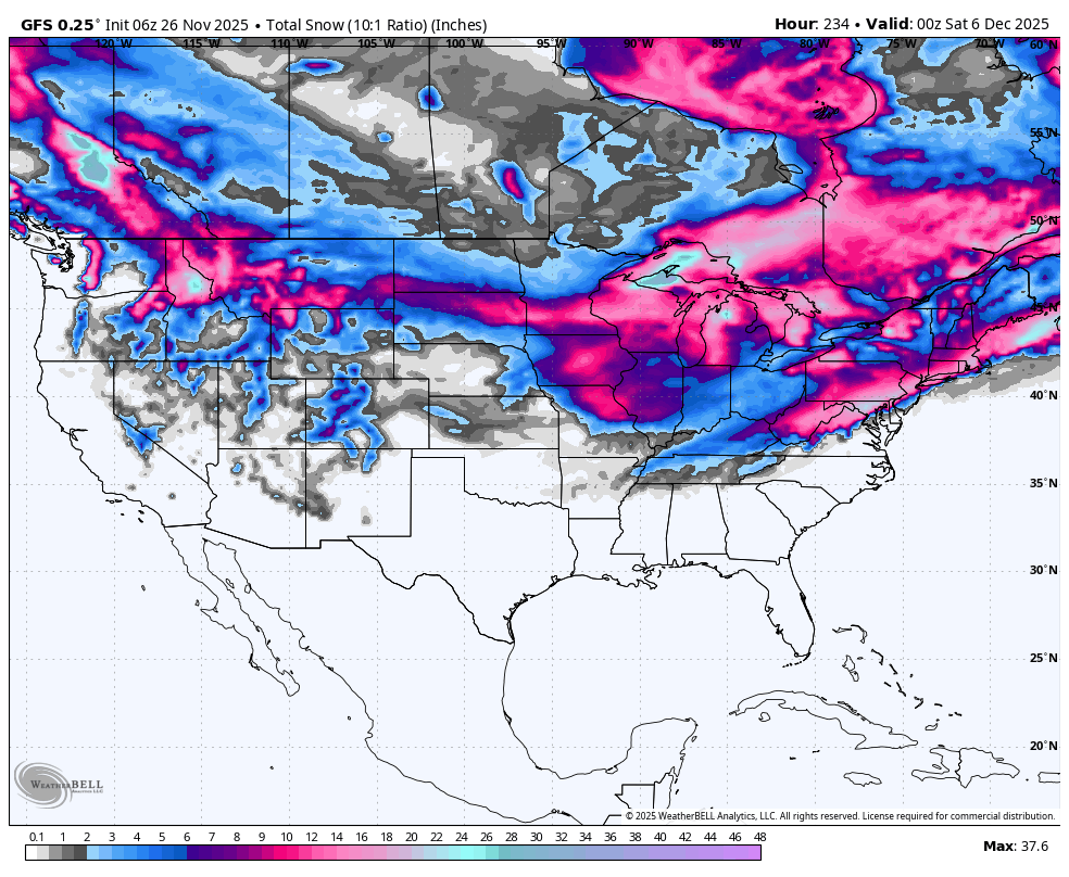
Below: Total 9-day moisture through Friday, December 5th, for the west. For 9 days, these numbers are not impressive aside from some 1-2 inch totals noted in the northern tier States. Canada might ramp up again later in the period (Dec-6-7) and especially near December 11-12 (not shown). The Sierra is Bone dry aside from a few southern locations. The Rockies are stuck with 3/4 inches of moisture (moderate snow). AZ and NM are also dry.

Below: Map 12/7 to 12/11. A weakening system might skirt into southern California on December 7th and advance north into the Rockies. Another and perhaps stronger wave is noted for Canada and the northern Rockies from December 8th to 9th. A third and stronger system is noted at the end of this loop for December 12th, moving into BC and the PNW. Hopefully, this digs south and impacts a wider area of the west. The models show strong signals for western Canada initially.

New England Powder
Below: European ensembles- Snowfall and cold temperatures are likely late this week (First pulse) in New England, ramping up towards the end of this loop mid or later next week (Dec 4-6). The map loop is from Sunday, November 30, to Saturday night, December 6th. The higher totals seem to focus on Canada and the northern tier of New England. Caveat: The GFS deterministic model is an outlier showing heavy snow over the metro areas of NY and NJ by December 3rd. The ensembles, however, show the action further north. The snowfall periods are later this week and again mid to late next week.

Below: Map: Thursday (Nov 27) through Sunday (December 7). Low pressure is noted later this week and again mid to later next week over New England. (Date and day in upper right). This seems to be an active period; however, snow totals might favor the northern areas and Canada (Too soon to forecast).
 Forecaster: Powderchaser Steve @powderchasersteve
Please support your love of powder and our forecasts with a donation here, or join our concierge program.


