
Summary:
_______________________
A series of small, low-pressure systems is expected to impact the Intermountain West from Friday night through Tuesday morning. These storms will be accompanied by cold temperatures, which will help boost storm totals, as snow ratios will hover around 17:1. The Northern Rockies see the moisture first, with 4-8 inches possible for parts of Montana and Wyoming. Utah will soon follow, with potential for 4-8 inches in the Little and Big Cottonwood canyons. However, Colorado will receive the most moisture, with areas like Steamboat and the San Juans targeting 7-10+". Both the PNW and California stay dry. Snowmaking should also be optimal across all the intermountain States mentioned. Scroll to the Extended section for a look at the next series of potential intense storms lining up for the December 4th-7th window.
Saturday AM Reports:
__________________________
Loveland: 7"
A-basin: 7"
Breckenridge: 4"
Winter Park: 5"
Big sky: 6"
JHMR: 6"
Bridger Bowl: 10"
Expected Snow Totals:
_______________________
Colorado:
Silverton: 6-10"
Telluride: 6-8"
Red Mtn Pass: 4-8"
Aspen: 4-7"
Vail: 6-8"
Crested Butte: 4-8"
Breck: 4-6"
A-Basin: 5-8"
Winter Park: 4-6"
Steamboat: 8-12"
Utah:
Brighton/Solitude: 5-8"
Park City/Deer Valley: 3-6"
Alta/Bird: 5-9"
Northern Rockies:
Tetons: 3-6"
Bridger: 6-10"
Big sky: 4-8"
SunValley: Trace-2"
SouthWest:
Taos: 2-6"
Sponsor Alert
This post is sponsored by Park City Powder Cats, who is our newest sponsor. Welcome, PC Powder Cats.

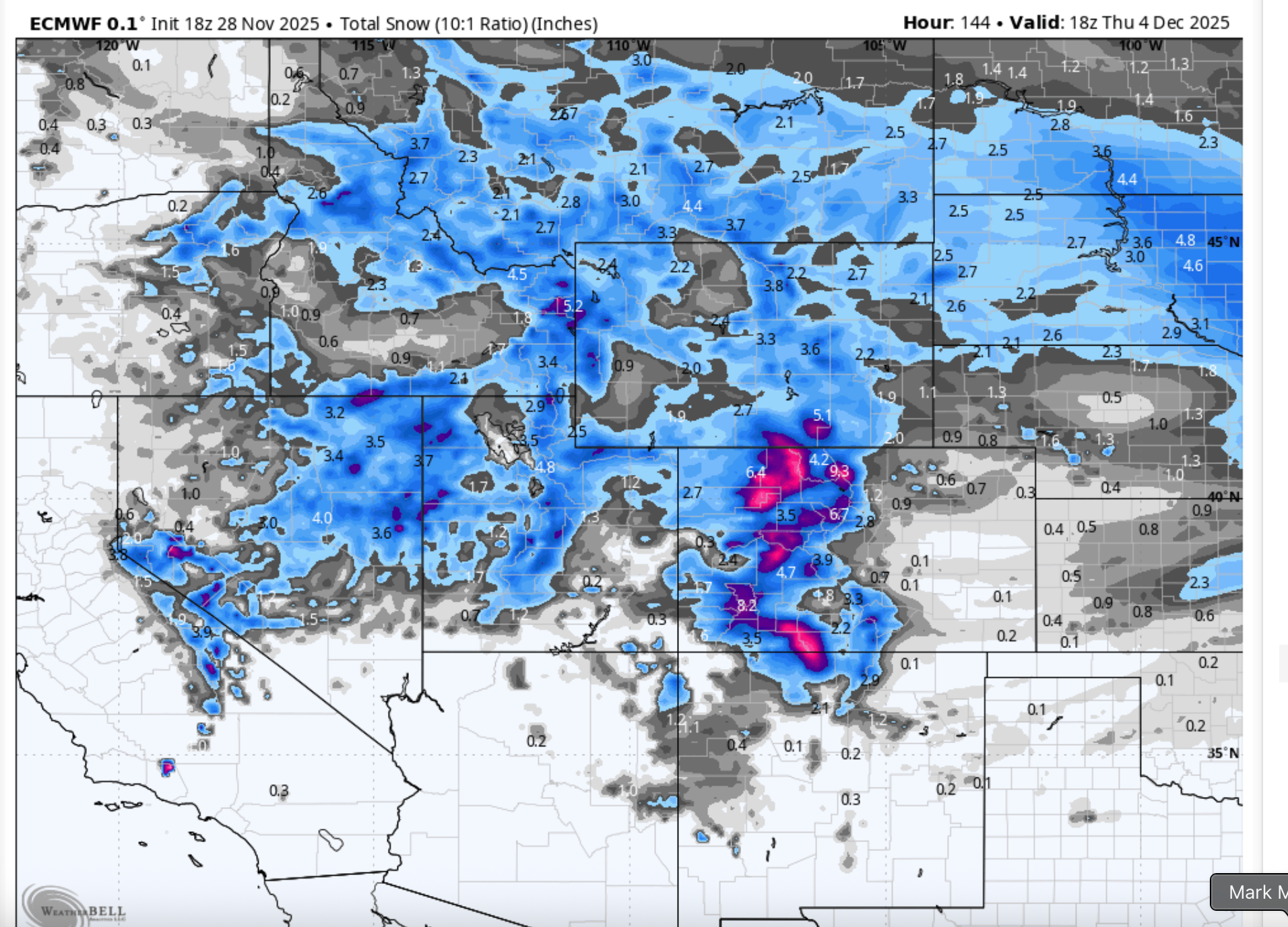
Below: Snow totals through early Tuesday morning (December 2nd). Areas highlighted in purple/pink, in Colorado, are in the 8-10" range.

Below: The map shows the total precipitation (inches) set to fall over the weekend and into Monday. Even though most regions are set to receive only 0.2- 0.6" of total precipitation, they will still receive decent totals, as the Snow to liquid Ratio (SLR) is reading 17:1 across most of the west, with areas like Steamboat seeing 20:1 for a few hours early Monday morning. For example, A 20:1 ratio means that 0.5" of water mixed with cold temperatures can easily turn into 10 inches of Snow. This SLR is great for overall totals; however, it is the type of Snow we call "Cold smoke," which blows off your body if you ski through it. While this is great for skiing, it is not great for base building.

Below: This series consists of 3 separate troughs, with the first trough moving on Friday night. The second is on Sunday night through early Tuesday morning. A third storm will hit Tuesday PM and last through late Wednesday Night.  Below: Temperatures plummet to single digits at 10,000ft. -14C on the map translates to 6F. These cold temperatures and good SLR ratios will once again help raise snow totals despite lower precipitation.
 Colorado
____________________
The first system to roll in Friday night will generally produce totals of 3-6" in the northern mountains, 1-3" in the central mountains, and a trace in the southern mountains. The next wave will roll in on Sunday afternoon with 2-5" for the northern mountains, 3-6" for the central mountains, and 6-10" for the Southern mountains. Highest totals will be in Steamboat (up to 12") and Silverton (up to 10"). Vail Pass should take the win along the I-70 corridor, with snowfall totals reaching up to 8" by Tuesday morning.
Montana / Wyoming /Idaho
_________________________
For the Northern Rockies, most of the Snow will fall on Friday night and move out by early Monday morning, with totals in the 4-8" range across southwestern Montana and northwestern Wyoming. However, a strong NW flow has already produced 10" since 2 pm at Bridger Bowl (see webcam below). The temperature will drop into the single digits in the mountains and into the teens in the valleys.
Below: Bridger Webcam as of 9 pm, Friday (11/28). NOTE* There was 6" already on the snow stake at 2 pm, which was old Snow that I disregarded.
 Utah
Utah
__________________
Utah will finally get on the board with moisture moving in on Sunday. Again, snow ratios will be around 17:1, meaning a little moisture could go a long way with these cold temps. I'm anticipating roughly 8" for Alta/Bird and 6" for Brighton. Park City and Deer Valley will receive 3-5". The heaviest Snow will fall throughout Sunday and into Monday.
Extended
__________________
Minor storm on the 2/3rd. Another storm has the potential to move in on the 6th (medium confidence), with more storms lining up on the 8th and 9th (high confidence).
OUR GOLD SPONSORS


Forecaster: Mark Mazzatta
Please support your love of powder and our forecasts with a donation here, or join our concierge program.


