
High-Level Summary
A colder, unsettled pattern favors frequent light to moderate snow across the Northern Rockies this week, with the best quality turns at Banff Sunshine and, from Wednesday on, Big Sky, while several future heavy hitters such as Whitefish, Schweitzer, Grand Targhee, Jackson Hole, and Revelstoke quietly stack light to moderate base building totals behind closed gates.
In the Pacific Northwest, a warm, moist midweek push drives snow levels high at times, so most of the deeper accumulations fall on largely closed terrain in the Washington and Oregon Cascades, although Whistler sees a steady, colder storm from Wednesday night through Friday. The clearest chase window for open terrain comes Friday, when Crystal Mountain opens into around 5-9 inches of fresh snow and Whistler, Banff Sunshine, and Big Sky each pick up a lighter but high quality refresh on top of several days of earlier snowfall. Stevens Pass and the I-90 corridor might sneak out some double digits Tuesday night (Snow levels rise Wednesday to above most bases). By the weekend, snow levels trend lower region wide, winds ease, and the broader pattern transitions toward colder, more wintry conditions heading into early December.
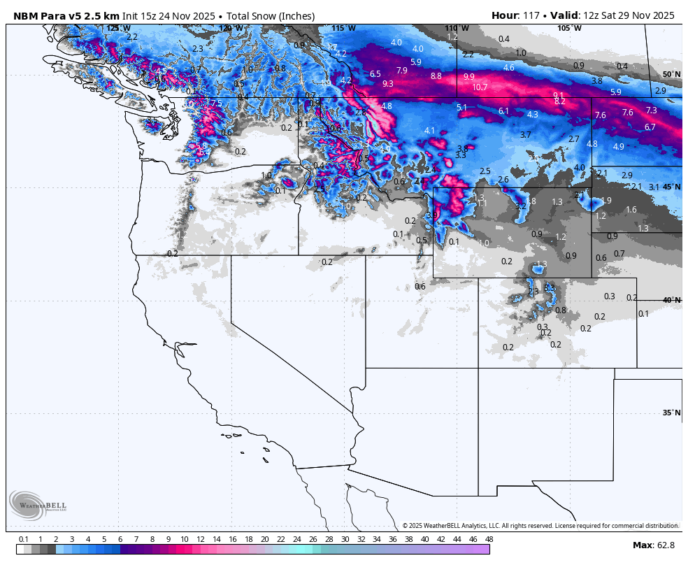
Below: Storm totals through Saturday morning in the west.

OUR GOLD SPONSORS


Key Points
Good
Repeated waves of moisture and cooling temperatures favor the Northern Rockies for quality snow. Banff Sunshine sees very cold temperatures in the teens and single digits with snow to valley floors and high snow to liquid ratios mostly in the upper teens, which supports fluffy, blower style powder even when daily totals are modest. Big Sky, Grand Targhee, Jackson Hole, Bridger Bowl, Whitefish, and Schweitzer all pile up around 4 to 9 inches or more through Friday with ratios in the low to mid teens and generally manageable winds, so snow quality and preservation will be strong once lifts are spinning. In the Cascades, the same active pattern drops double digit totals by Friday over Stevens Pass, Crystal, Timberline, Snoqualmie Pass, and Mount Baker, with snow levels trending down later in the week and very light winds at Whistler supporting smooth, surfy conditions.
Bad
Warm sectors early to midweek hurt snow quality in portions of the Pacific Northwest. Snow levels in the Oregon and southern Washington Cascades climb above roughly 6 thousand feet at times Wednesday, which means mixed precipitation or wetter snow around some mid mountain bases even as upper elevations accumulate. Most of the snow fortunately will fall prior to the warming especially near Stevens Pass.
Late week- Weekend Storm.
Model guidance still disagrees on the exact track and strength of systems late in the week and into the weekend, especially around how quickly a colder upper trough digs into the western United States. Small shifts will change who sits under the heaviest moisture plume versus who sees more showery activity, particularly in the Washington and Oregon Cascades from Thursday into Saturday. There is also uncertainty around the timing and depth of colder air spilling south out of Canada toward the weekend, which will control how low snow levels fall for valley locations and how long the colder, drier powder regime can hold into early next week. Finally, rapid ramp up of operations at newly opening resorts such as Big Sky, Crystal Mountain, Mount Bachelor, Brundage, Jackson Hole, and Revelstoke may limit terrain despite favorable snow on their opening days, so actual ski experience will depend not only on snowfall but on how much terrain each area can bring online.
Daily Forecast (Monday November 24 through Friday November 29)
Monday (November 24)

A cold front slides across the Northern Rockies, bringing light to moderate snow focused on Montana and northwest Wyoming. Banff Sunshine, one of the few open areas, picks up around 1 to 2 inches of very light, cold snow during the day with temperatures in the teens, snow levels well below the base, and light winds, which offers a soft refresh but not a true chase. Behind the scenes, Whitefish Mountain, Big Sky, Bridger Bowl, Grand Targhee, Jackson Hole, and the higher Idaho ranges collect roughly 2 to 4 inches combined through Monday night with high snow ratios and falling snow levels, which is ideal base building for later in the week, but these areas remain closed. The Pacific Northwest is comparatively quiet for ski areas today with only light showers and cooling temperatures over the Cascades and Whistler still between storms.
Tuesday (November 25)

The pattern splits a bit. A warm, moist push reaches the Oregon and Washington Cascades, bringing snow and mixed precipitation mainly to closed or not yet open terrain. Snoqualmie Pass sees around 5-9 inches Tuesday by combining daytime and Tuesday night snowfall, while Stevens Pass and Crystal Mountain might see similar totals. Convergence Zones Tuesday evening might enhance totals near I-90 or up to Stevens Pass. Snow levels rise toward 5 to 6 thousand feet with denser snow or a mix possible around some bases Wednesday. Timberline and Mount Bachelor also pick up light snow, but both remain closed. .
Wednesday (November 26)

Wednesday is a transition day with meaningful snow but still limited chase options. The Washington and Oregon Cascades are in the heart of the midweek storm, with Crystal Mountain, Stevens Pass, Snoqualmie Pass, Timberline, and Mount Baker all adding midweek totals. Crystal gains around 4 to 6 inches by combining Tuesday night and Wednesday snow, and Stevens Pass climbs to roughly 5 to 10 inches for the same window, but all of this lands on closed terrain. Grand Targhee and Jackson Hole collect around 3 to 4 inches from Tuesday night into Wednesday, and Big Sky sees around 1 to 2 inches as snow levels stay well below the bases with moderate to high snow ratios. Big Sky opens Wednesday, so expect soft, wintry conditions with several inches of earlier snow from Monday underfoot, but the new snow for the day is modest and winds remain moderate, so this leans more toward a pleasant opening day rather than a deep powder chase. Whistler and Banff Sunshine are mostly between storm waves and stay quiet.
Thursday (November 27 – Thanksgiving)

Thanksgiving shifts the focus toward the Pacific Northwest as the Cascades storm begins to cool. For open terrain, Whistler becomes the main story. From Wednesday night through Thursday daytime, Whistler picks up around 2 to 3 inches of new snow with moderate density (snow to liquid ratios mostly near ten), snow levels around 3 to 4 thousand feet trending lower, and very light winds. This creates a soft, surfy top layer without significant wind effect, making Whistler the best open lift option for a modest holiday refresh. Big Sky adds roughly 1 inch from Wednesday night and Thursday combined, enough to keep surfaces chalky and winterlike but not a stand alone powder target. Banff Sunshine only sees a trace on Thursday, with its next meaningful burst holding off until Thursday night. The heaviest totals Thursday still favor closed terrain from Stevens Pass southward through Timberline, Mount Hood, Snoqualmie Pass, and Mount Baker, which continue to add several inches on top of already healthy early week totals.
Friday (November 28)
Friday is the clearest regional chase day of the period and lines up with several major openings, with Crystal Mountain offering the best combination of depth and timing in the Cascades as it picks up roughly 3 to 5 inches of new snow from Thursday night through Friday along with lowering snow levels, favorable snow ratios, moderate winds, and support from earlier midweek accumulations that should make upper mountain lines feel legitimately powdery despite the modest overnight and daytime totals; Whistler collects another 2 to 3 inches in the same window for a Wednesday night through Friday total near 4 to 7 inches with consistently cold temperatures, low snow levels, and very light winds that support smooth, creamy conditions; in the Northern Rockies, Banff Sunshine, Big Sky, Brundage, and newly open Jackson Hole all see lighter but high quality refreshes, including 2 to 3 inches at Banff Sunshine with low snow levels, very cold temperatures, and high snow ratios that will ski blower like, 1 to 3 inches at Big Sky with cooling temperatures and moderate winds that should maintain soft, chalky surfaces atop earlier accumulations, and 1 to 2 inches at Brundage paired with recent snow for a solid local opening day, while Mount Bachelor opens with less than an inch and a warmer, windier setup that keeps it off the powder target list for now; overall, Friday chasers who want the deepest feel should focus on Crystal Mountain, while Whistler, Banff Sunshine, and Big Sky provide slightly shallower but still high quality or less crowded alternatives.
Region by Region Details
Northern Rockies
The Northern Rockies sit under repeated shortwaves in west to northwest flow, so light to moderate snow returns several times this week with a notable cold front Monday and another wave Tuesday night into Thursday. Early in the week, colder air behind the front drops snow levels to valley floors and brings around 3 to 5 inches to Whitefish Mountain, with similar totals of 3-7 inches over the higher terrain at Grand Targhee, Jackson Hole, Big Sky, Bridger Bowl, and the central Idaho mountains through Friday, all with snow to liquid ratios mainly in the low to mid teens. Banff Sunshine and Revelstoke see more modest totals of roughly 3 to 6 inches, but the snow there falls with very cold temperatures, very low snow levels, and light winds, so expect dry, blower style powder and excellent preservation on open or newly opening terrain. Overall, the deepest moderate storm totals favor closed or not yet fully open mountains like Whitefish, Schweitzer, Grand Targhee, Jackson Hole, and Bridger Bowl, while open areas such as Banff Sunshine and soon to open Big Sky and Revelstoke trade slightly lower depth for consistently cold, high quality snow.
Pacific Northwest
Extended Outlook
Looking beyond Saturday into the first week of December, large scale guidance keeps a broad trough over the western United States with ridging over the northeastern Pacific and Alaska, a pattern that favors below normal temperatures and recurring storm systems for much of the West. This supports continued opportunities for snow in the Cascades and especially the Northern Rockies, with the highest odds for additional activity and colder, more wintry powder days from interior British Columbia through Montana, Idaho, and Wyoming as the calendar flips into early December. Colorado is also in this path later this weekend and earlier next week, with the Wasatch a wildcard.
One model (GFS) takes the action along the CA coast (Sierra) Which would boost totals for CA,NV, UT, and the four corners. We are not ready to buy off on that just yet.
Please support our sponsors! Tire Rack has a promotion on Blizzak Tires with a $80 prepaid Mastercard rebate with the purchase of any 4 tires. Please support your love of powder and our forecasts with a donation here, or join our concierge program.


