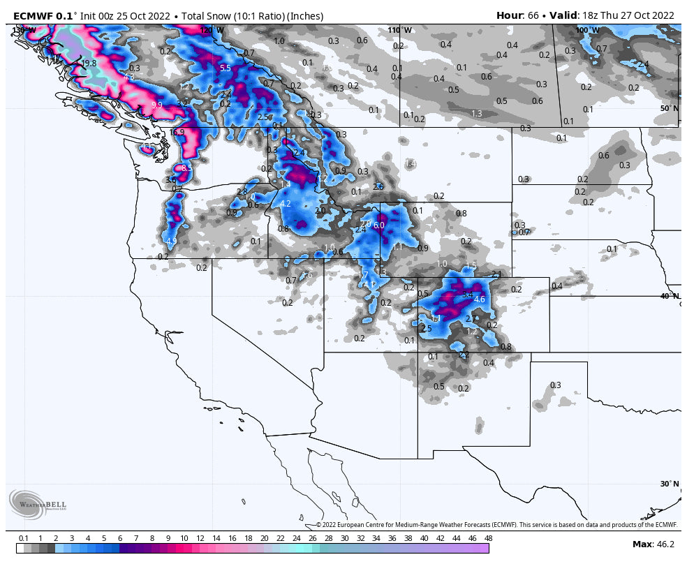
The next 7 days are going to feature the most activity in Canada, Pacific Northwest, and most of the northern Rocky Mountain ranges. Currently it is snowing in the PNW with most model data favoring areas from Stevens Pass to Mt Baker in the short term. Snow will spread further south into the southern Cascades and perhaps Oregon by Tuesday night or Wednesday morning. It's likely that by Wednesday some ski areas will be reporting 6-10 inch totals (Tuesday-Wednesday). Mt Baker could be on the high side of this range, however some isolated areas even south could ramp into the 4-9 inch range (Stevens, Crystal, Timberline- Bachelor-Wildcard). Whistler and areas in coastal BC will also do well with this storm (5-11). The upper elevations of BC north of Whistler (north coast range) could see significant snow in the next several days (1-2 feet). Snow levels will be low for this storm.
Meanwhile in the Rockies after a significant dump for some areas of the Rockies (2 feet in southern Montana and northern Utah last weekend), snow showers will be most evident in the Idaho Panhandle especially northern or central sections (Selkirk Powder near SandPoint may also do well). That system edges into the Tetons, Northern Utah, and Colorado by Wednesday. Amounts seem to favor the Tetons and northern Colorado with perhaps 5-10 inches in some areas. Utah may score similar or slightly lower amounts but the most favored chase picks could land near Logan (Beaver Mountain) or further south towards I-80 or in the Cottonwoods under W-NW flow. While this is not a major system, cold air and model data suggest orographic's may bring some upside surprises to a few ski areas by late Wednesday night.
Below: Track of the low pressure system from the PNW edging into the northern Rockies by Wednesday/Thursday.

Below: University of Utah multiple ensemble runs showing light snow in the Tetons Tuesday and increasing again into Wednesday. The Tetons could score 7-10 inches with both rounds of precipitation and perhaps higher amounts as moisture decreases late Wednesday night. The mean averages are around 12 inches with a few in the 5-9 range. I think 7-10 is a reasonable forecast for the Tetons.

Below: University of Utah ensemble data for Mt Baker Ski area showing persistent snow showers this week that may also add up to some decent totals (Slowly building with no specific peak event). There is good consensus on this map with tight lines representing the mean averages (We would expect 10 inches from this storm as this models tend to be slightly overdone).

Below: Same data for Steamboat showing poor consensus on amounts (Lines are not tight) and anywhere from 5-10 inches or higher. We feel that 7-10 inches is certainly possible for mid or upper mountain by Thursday morning.

Below:High Resolution HRR model showing highest totals over the Tetons, northern Utah and Colorado through Wednesday night. In Colorado snow will spread south, however its possible resorts on the western side of the I-70 corridor from Vail Pass to Aspen do better than it's counterparts on the eastern side of I-70 (Wednesday).

Below: Total snow for Colorado through Thursday PM. Higher amounts are possible in some of these areas with general totals from 4-10 inches.

Extended POW
The ensembles show some ridging and high pressure settling into the Rockies late this week and weekend. Some moisture might continue for the PNW and areas of Canada adding to the snow totals. There is another stronger system moving into the Pacific Northwest by Halloween that might drop south over the intermountain west during the first few days of November. It is likely that the Rockies begin to seem some snowfall during this period. Even the Sierra may see some flakes. The highest totals are still likely to be in the PNW, and Canada. This system will deserve watching.
Below: High pressure over the Rockies later this week and weekend. Low pressure still noted over Canada and the PNW.

Below: Deeper low appears likely over the PNW and Canada by October 31st (Halloween) that should spread some moisture south into the intermountain west during the first week of November.

Please join our Powder Concierge that provides you custom powder chases this season. This will get you to the deepest resorts and provide you customized weather forecasts for your chases. Please support our sponsors and check out the latest pass options from our partners (Mountain Collective, Indy and Ikon). If you want to support Powderchasers with a donation to you can do that here.
Thanks for following this early in the season!
Powderchaser Steve - Instagram @powderchasersteve


