
The weather room at Powderchasers is on overtime as models continue to show the next impacts of the storm system due in the Pacific Northwest Friday/Saturday and the Rockies Saturday/Sunday. We are transitioning from one of the driest summer/fall periods to a very wet period. This next storm looks good, especially for October. The Midwest beat out all other areas this season with deep powder turns on Monday. Hats off to those that made turns!
Not every ski area will grab these high-end totals, but by Monday morning our predictions call for widespread 5-10 inches on the low end, with some resorts grabbing 15-30 inches at the summits. The exact track of this system and any changes can result in last-minute chases. We actually think this might be a chase-worthy storm especially if it comes in wet and finishes light. Some areas will be very deep, especially in the highest elevations of the Rockies.
The current track of this system seems to favor the central and southern Cascades of Washington initially Friday PM/Saturday (5-10) and even more so for Oregon. Areas near Mt Bachelor in Oregon might grab higher amounts by late Saturday and could actually be skin worthy. One model showed higher amounts for White Pass or perhaps Crystal as well. If a convergence zone sets up over Stevens Pass it may also be deep, however, the current data shows that heavy precipitation is just east of the Ski area. Bottom Line PNW: The trend is for central or southern areas of the PNW to do best with this system. Winds will be very strong initially, especially over the southern Cascades. The deepest totals will likely fall over Mount Rainier, and towards Bachelor in Oregon. White Pass, Crystal, and perhaps Stevens are wildcards. Snow levels plummet to 4,000 feet so some snow will be at pass level or even below by late Saturday. If I had to gamble on Canada it would be southern Alberta or BC, perhaps the lesser-known ski area called Castle Mountain (the Coolest snow stake in the industry).
Below: Most of the Cascade Range grabs freshies, however, we feel the southern areas especially over Oregon might do best.

Elsewhere in the west widespread snowfall is likely from Idaho through Montana, Utah, Wyoming, and Colorado. The trend is for the highest amounts to land somewhere in the northern Panhandle of Idaho (Selkirk Powder) through Southern Montana and northern Wyoming. Significant snowfall is possible for the ski areas near Bozeman including Big Sky or Bridger. For the Tetons, it's going to be a close call with heavy snow likely on the northern ranges of the mountain range from Moose to Yellowstone and slightly less to the south. The European models display 5-10 inches for the southern Teton range with the American Model in the 10-15 inch range with perhaps higher amounts at the summits. Winds in the Tetons start out favorable from the SW (Wetter snow Saturday PM) and migrate to a much colder pattern Sunday (Snow to the valley floor). There is a period of NW flow that often helps Targhee best, with a shift to a more northerly direction Sunday. North winds generally don't perform as well for the Tetons. Regardless, Teton Pass will be snow-covered as early as Saturday evening or early Sunday.
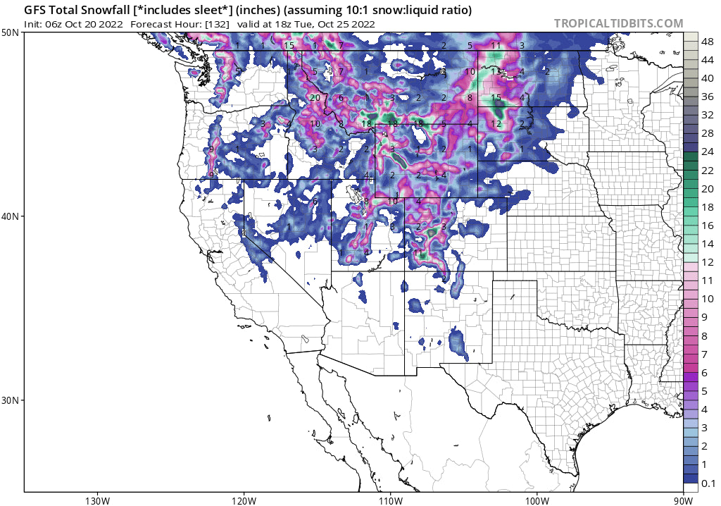
Below: The American GFS is very bullish for Southern Montana and the Teton Range. If this scenario happens expect 10-15 inches for the ski areas with some higher amounts in Montana. The European pushes the heaviest moisture a bit further north in Wyoming. We are not confident about totals in the Tetons due to a shift of winds to the north which could produce less snow. Valley snow is very likely Sunday!

Utah looks to perform very well in this storm. On Saturday winds will be gusting from the SW (pre-frontal). Goodbye fall colors as most leaves will be gonzo. Snow develops Saturday PM and continues into Sunday evening. NW flow will stack up totals from 12-28 inches in the Cottonwoods, and 6-12 inches elsewhere. Park City could do very well at the summit, especially on the Canyon's side. Look for some upside surprises perhaps at Powder or even perhaps Beaver as a wildcard.
Below: University of Utah Little Cottonwood Guidance along with the ensembles all indicating a pretty hefty event for the Wasatch Range. Some areas may exceed 2 feet by later Sunday. Areas outside the Cottonwoods will grab 6-12 inches above 7,000 feet. This could be a very good storm.

For Colorado, our last forecast highlighted the central and southern mountains. Models are still trending in that direction. There will be a period of heavy snow from Sunday to early Monday. The highest amounts (Excess of 12-20 inches) are likely in the Elk or Swatch ranges (Aspen, Crested Butte) in the central mountains and perhaps 12 plus inches over Telluride, Wolf Creek, or Purgatory. Silverton could score higher amounts. Further north expect 5-10 inches with some upside surprises possible for Vail Pass (Winds shift to the NW on Sunday later AM) with less snow possible further east. Steamboat can sneak up higher amounts initially under SW winds. Bottom Line: This is a very good storm for central and perhaps southern Colorado. All ski areas in Colorado will see snow with a good start to base building. Colder temps will allow a longer duration of snowmaking. Any change in the path of this storm could bring higher amounts further north and east.
Below: Total precipitation in deep red directly over the Roaring Fork Valley near Aspen and the Gunnison Range. 2 inches plus of moisture could equivocate to 20-28 inches at some mountain peaks in or outside the ski areas. Elsewhere in yellows, there is nearly an inch of liquid, even towards Vail Pass, and higher amounts near Telluride or Red Mountain Pass to the south. This model tends to be a bit overdone when compared to others but it's not out of the question.

Below: The European model shows less moisture, but a pretty similar path (1- 1.5 inches of liquid).

Extended
The pattern continues to be very active in the Pacific Northwest with a break Sunday and precipitation continuing nearly every 24 hours with 2 additional storms next week. These systems will weaken somewhat but move over the Rockies bringing additional chances of some snowfall. The map is from Sunday (Departing storm over Colorado) through late Wednesday night next week. It looks like the Sierra might get a taste at some point by mid to late next week. The date and day are on the upper right.

Announcement: Put your snow tires on now! We normally wait until November but have already started gearing up our chase fleet. Please support Powderchasers and our sponsor Tire Rack who can overnight them to your home or Discount Tire in the west. Support our pass sponsors by purchasing here Ikon, Mountain Collective, and Indy who all offer unique solutions for multi-resort riding. When chasing powder it can't hurt to have all of them in your bag. They are all unique to your chasing needs.
If you want to chase powder all winter or never want to miss a deep day when planning a trip join the Powder Concierge. Please support Powderchasers with a donation for its free forecasts here. You can sign up for free powder alerts on the website here.
Thanks for following along to the end!
Forecaster- Powderchaser Steve. @powderchasersteve


