Summary:
Very wet conditions continue in the Pacific Northwest, BC, that migrate to the northern Rockies by Monday night and Tuesday. Warming is an issue for some lower elevations with a cooling trend Tuesday-Friday and additional storms for the west. The PNW and Rockies could score again later this week.
Going into this forecast we updated snow totals on Friday evening. The Tetons hit my target of 8-14 inches for 1st chairs on Saturday with epic conditions. Snow tapered in the Tetons by Saturday afternoon, however, the elevations above 10K continued to reap new snow (Sunday would have also been decent). For Colorado, the forecast issued was for 3-7 inches and I highlighted Steamboat, Aspen, Beaver Creek, and Sunlight. While it's not often you hit the nail on exactly which areas (Especially in Colorado) nab the highest totals it turns out that Steamboat was at 8 inches, Snowmass, 8, and Beaver Creek at 5 inches. Snow continued to fall over Steamboat with an additional 3 inches on Sunday morning. Winter Park and Telluride also did well.
Our choice for powder took me from Jackson Hole to Snowmass. We think nearly every chair is high-speed now.
Forecast:
The next week features several deep storms albeit warming temps. Currently, it is raining below 4200 feet in the Cascades and snowing heavily at mid and upper mountain elevations from Stevens to Mt Baker. Baker has 17 inches since Sunday morning (Wet snow). Further south near Crystal they have seen 1-5 inches (Elevation dependant). Significant high elevation snow especially in the central and northern Cascades of Washington will continue through Monday night. Much colder air moves in late Monday with snow quality improving albeit also a decrease in precip rates. Tuesday might feature 2-5 inches of low-density snow on top of a cushion or frozen layer. It could be really fun ripper snow, or in some spots on the funk side. Deep up top especially the central and northern Cascades of Washington.
Below: High-resolution short-term HRR models showing the cooler air arriving over much of western Washington by late Monday. This will change any rain over to all snow at lower elevations.

Moisture from the Cascades transforms the central Pandhandle of Idaho (Lookout Pass) where significant amounts of snow will fall (High winds). Moderate snow will be falling near the Montana Snowbowl near Missoula with heavier snow further east (Discovery). Light to moderate snow is also seen on the models for Brundage, northern Panhandle, and near Selkirk Powder (Northern Idaho).
In the Tetons, snow develops Monday night under warmish temps (32 at the base) with increasing winds. 4-8 inches are likely by Tuesday morning (S, SW winds gusting into the '40s and '50s) Temps cool late Monday night increasing snow quality for Tuesday morning (Additional 1-3 inches). While amounts could be decent, the caveat is wind speeds (Upper elevations might buff out) and initially warm temps. Cooler temps on the backside of this front might present some ripper turns for Tuesday morning (Fewer face shots than the previous storms). Mid or lower elevations might ride better than the summits.
Below: Low-pressure Trough favoring the northern Rockies late Monday and Tuesday.

Below: Sustained winds in the 40s and higher (W, SW) at 10K feet for much of Montana and Wyoming late Monday night and early Tuesday morning. Winds decrease late Tuesday AM with shifts to the NW.

Extended:
Looking out for powder this week some light snow continues to track from BC and the PNW over the northern Rockies. It appears that areas of Montana, Idaho, Washington, and even the Tetons in Wyoming continue to see some light snow events with a cooling trend.
Colorado grabs a Front Range storm Wednesday night into Thursday that might provide a decent event for Eldora, Rocky Mountain National Park with A-Basin, WP, and Loveland wildcards.
Below: Snowfall for the Front Range of Colorado for Thursday favoring metro areas, and areas east of the Divide. The pink area is just east and south of Boulder (Adams County). Too far out to speculate on Ski Areas.

Further out, an impressive-looking system might move into BC the Pacific Northwest by Thursday. This will dig a bit further south over Oregon and drag east towards the Rockies. The northern sections of the Rockies once again appear to be favored with more powder likely for many ski areas. This might provide an increased chance for areas further south as well.
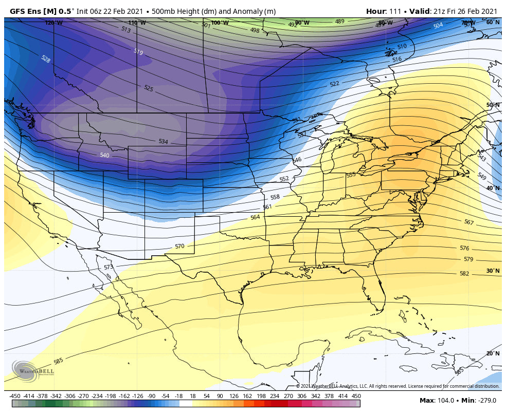
Below: Trough digging a bit further south for the late week storm by Friday morning over the Rockies. Stay tuned.

Below: The late-week Trough ends up in the 4 corners by Sunday morning.

Alaska Update: Valdez is deep! Snow banks are over 10 feet high at sea level. If you want to still get in on the few remaining seats to Heli Ski (Limited) please reach out to Alaska Backcountry Guides who we trust highly for a great deep lines. Powderchasers is offering a free mid level concierge for this or next season for any ABG trips. Also, with the demand for skiing way up, there is not a better way to jump into untouched terrain with small group Heli Runs.
Please consider a donation to support our powder addiction and forecasts. Also, if you have joined our concierge program, please reach out to us 7-14 days ahead of your travel plans for some custom forecasts.
Stay tuned to Powderchasers! Enjoy the powder, but remember, AVY danger while already one of our worst seasons in the west will likely get even worse this week with winds and warming temps.
Also, follow forecaster and rider @lstone84 on instagram for additional storm footage.
Powderchaser Steve - Snow Forecaster.


