SUMMARY:
Wild weather with widely spaced temperature variances has created significant avalanche danger in the Washington Cascades. Another 3-4 feet is possible through Saturday. The Rockies tease in the next few days before perhaps a better system moves in for Friday or Saturday. The Front Range Metro areas around Denver could score decent snow for Thursday (Boo Hoo for the Ski Areas).
FORECAST:
In the past 24 hours, 22 inches fell at Stevens Pass Ski Area (70 inches in 7 days). Temps were warm initially and have dropped significantly with snow continuing to fall. The Ski Area announced on Monday that it will remain closed on Tuesday (Stevens is Closed for the day). Significant avalanche results were also noted on US Highway 2 on Monday. Less snow fell towards Baker and Snoqualmie. When Stevens opens on Wednesday, it will be deep but expect long delays on terrain openings for avalanche mitigation.
Below: NWAC telemetry showing 22 inches since 6 AM Monday at Stevens Pass. Notice the temps were warm yesterday with the cold front lowering them significantly after 9 PM.

On Tuesday the models are hammering out significant snowfall focussing on Stevens Pass and perhaps I-90 near Alpental with convergence zones. It's possible another 12-16 inches occurs in these areas through Tuesday evening. Don't expect normalcy with travel plans (Highway impacts, Ski Area Closures, or limited terrain). Further south Crystal could be a safer bet with 8-9 inches new (Came in warm) and another 3-7 inches likely by closing chairs on Tuesday.
Below: Stevens Pass, Highway 2, on Monday after avalanche mitigation.

Elsewhere on the chase, the Tetons will continue to see light to moderate snowfall with strong winds. While 9 inches of dense snow fell yesterday temps have cooled so anything that does come on Tuesday will be high quality. Caveat: Strong wind buff likely at upper elevations. Amounts don't look impressive today.
Colorado scores some powder in the metro areas near Denver Wednesday night into Thursday morning. Perfect timing! Unfortunately, this storm will only graze the mountains with NE wind (Upslope). It's possible that Eldora or Rocky Mountain National Park come up with moderate amounts with the highest likely near or just east of Denver.
Honorable Mention: Whistler Ski Area just hit 100- inch Mid- Mountain base this week (Go Canada).
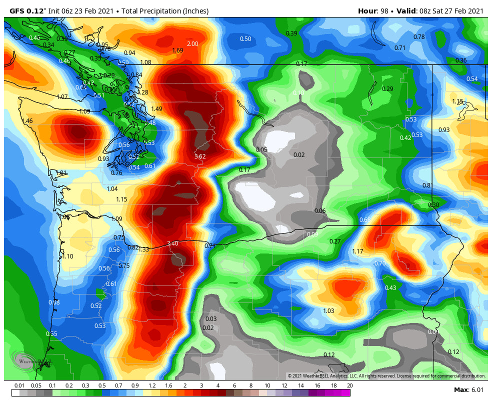
A very strong trough approaches coastal BC by Wednesday night. This will move into the Pacific Northwest by Thursday morning bringing an extended period of snowfall for a wide area of the PNW. While the past system focussed on Washington (convergence zones) this storm will dig south into Oregon. 2-4 feet of snow are possible over a wide area of the Cascades. This system has West, NW wind directions which might favor areas from the central to the southern Cascades. Cold temps will also bring high quality.
Below: Total Moisture for the Cascades from Tuesday morning to Saturday (Wide area of 3-4 inches of liquid precipitation).

This system translates to moderate or heavy snow over the northern Panhandle of Idaho (Selkirk Powder), Central Idaho, and even areas south to perhaps Sun Valley (Moderate amounts late week). Whitefish Montana could also see decent amounts along with Glacier National Park.
The next stop appears to favor the Tetons late this week or early on the weekend followed by the Wasatch. Friday and Saturday could be decent in these areas but details are just emerging. Big Sky and Bridger are likely to finally score a decent powder day late this week (Wildcard picks).
Moisture decays somewhat as it reaches Colorado with light or moderate snow likely for most of the central and northern mountains this weekend.
Alaska Update: Valdez is deep! Snow banks are over 10 feet high at sea level. If you want to still get in on the few remaining seats to Heli Ski (Limited) please reach out to Alaska Backcountry Guides who we trust highly for a great deep lines. Powderchasers is offering a free mid level concierge for this or next season for any ABG trips. Also, with the demand for skiing way up, there is not a better way to jump into untouched terrain with small group Heli Runs.
Please consider a donation to support our powder addiction and forecasts. Also, if you have joined our concierge program, please reach out to us 7-14 days ahead of your travel plans for some custom forecasts and location planning.
Enjoy the powder everyone!
Powderchaser Steve


