Summary
High confidence for a decent event for Oregon and the Sierra by Thursday night/Friday. The Rockies fire once again for Friday-Saturday and again late this weekend into early next week. Sneak up powder possible for Colorado Wednesday
Forecast
The next significant system is due for the PNW by Thursday PM to Friday AM. That trough has decent energy, cold air, and could even put down some light snow in the lowlands from Seattle and south. The models are in disagreement on the positioning. The European model shows snow from Stevens Pass through to the southern Cascades (Crystal) where the American model pushes most moisture south over Oregon with only moderate amounts for the southern Washington Cascades. The Canadian keeps Washington out of the picture. Bottom Line: Snow will be falling over the Oregon Cascades late this week (Heavy at times), pushing north into Washington with the southern resorts being favored (Model disagreement).
Below images: NAM 12 showing a trend further south for the Friday storm over Oregon. The GFS (bottom map) shows better reaches into the southern Cascades of WA. The European Model, not shown has this system even further north. Best Guess: Southern Washington does okay, Oregon Scores, and the northern or central WA Cascades miss the deepest amounts.


The trough mentioned above drops south over the Sierra with a high confidence dump for Friday morning (7-14). This seems to favor the entire Sierra Range from Interstate 80 through to Mammoth Lakes. Ride late Thursday or early Friday.
Meanwhile, for the Rockies, a short wave with limited moisture will land over Wyoming, Utah, and Colorado bringing light snow to the Wasatch and Tetons through Thursday morning. Light snow showers and several periods of 2-3 inches are likely through Thursday. One exception is moderate snow is more likely for Colorado especially Tuesday night into Wednesday. West-SW winds will favor Steamboat, Aspen, and Crested Butte, where a sneak up powder day is possible (4-8 inches). The I-70 corridor will see light to moderate amounts for Wednesday morning (2-4) with the western edges seeing slightly higher amounts (Beaver Creek). Rocky Mountain National Park is a solid wildcard (5-9). Bottom Line: Freshening light snow for most of the I-70 corridor of Colorado with the highest amounts further north over Rabbit Ears Pass, and wildcards for Aspen, Crested Butte, and Rocky Mountain National Park. Light snow continues for the Wasatch and Tetons through Thursday.
Extended
As mentioned above, the Sierra and Oregon, and southern Washington Cascades all see a decent storm late week. That system will transition over the Rockies initially with warm temps and moderate to heavy snow for the Wasatch, Tetons, and Colorado for Friday. The models show discrepancies. Some show the heaviest snow favoring the Tetons and others show equal or higher amounts for the Wasatch (European is further north while the American model further south). Colorado will begin to see moderate snow falling on Friday that will accumulate nicely into Saturday. Currently, the favored locations with SW or West flow will be the western I-70 corridor, Steamboat, Crested Butte, Aspen, extending south into Silverton, and even the southern San Juan Ranges. This will be a decent event for the core of the I-70 as well, however, it's possible that some areas come up with lower totals than the above-mentioned areas. It's too early to get into details so stay tuned!
Below: Temperatures Friday morning at 10K are bitter cold over central and northern Montana but still warm for the Tetons, Wasatch, and Colorado (-5C). Snow on Friday might be on the denser side initially until colder air works down later Friday or Saturday.

Below Images: American Model (Top) showing equal spread of snowfall from the Tetons and Wasatch with Colorado in good scoring position. The lower image pushes more moisture north over the Tetons and less for the southern Wasatch (Alta), but still decent amounts north of I-80 (Powder, Snowbasin, Beaver). This storm might favor the northern regions of Utah but it is still too early to forecast.


Another strong system and much colder air approach the Rockies late this weekend into early next week. This will bring some of the coldest temps of the season and additional snow. Stay Tuned!
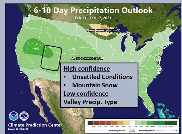
Below: Climate Prediction Center 6-10 days of above-average moisture for much of the west. - NWS- Salt Lake City. Good news!

Below: Climate Prediction Center - Temps below normal. NWS- Salt Lake City- Good News!

Enjoy the powder everyone! Please Donate to keep our forecasts going or join our custom concierge program.
Please follow our forecaster @lstone84 on instagram for live action from all the recent chases.
Powderchaser Steve


