
The past few days brought much-needed base-building dense snow to areas of Idaho, Montana, Wyoming, and Colorado.
Here are a few totals over the past several days (Friday-Sunday)
Copper Mountain: 19 inches
Alta: 18 inches
Loveland: 17 inches
Grand Targhee: 17 inches
Breckenridge: 17 inches
Arapahoe Basin: 16 inches
Eldora: 16 inches
Vail: 15 inches
Ski Lookout (Idaho) 15 inches
Crested Butte: 15 inches
Park City: 13 inches
Solitude: 11 inches
Jackson Hole: 10 inches
Aspen: 9 inches
Below: Saturday morning powder in Little Cottonwood. Both Alta and Snowbird opened on Sunday. Photo: @powderchasersteve

High-Level Summary:
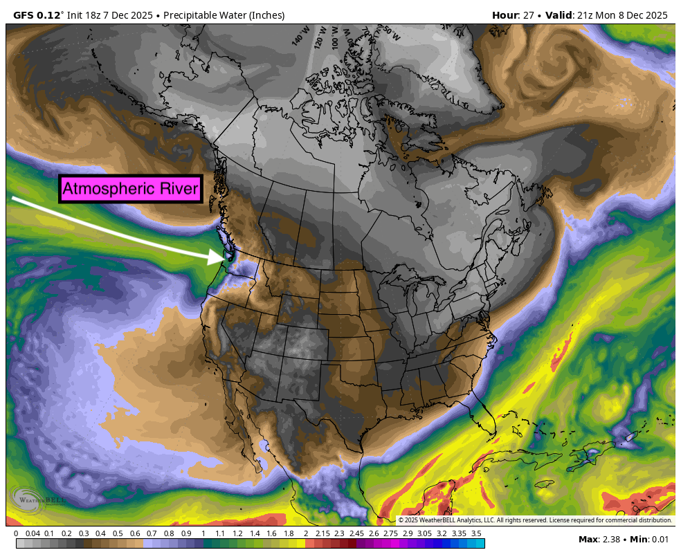
An incoming atmospheric river is going to bring substantial moisture to the Pacific Northwest. Unfortunately, snow levels spike with each passing wave, pushing snow levels from 4,000 to as high as 7,000 feet early this week. Each passing wave of moisture is followed by cooling, especially midweek, where some snow may accumulate in the Cascades (Northern and central areas in Washington are favored) for 4-9 inches of wet snow (Mid mountain). Strong winds will also be present.
Canada stays slightly cooler with higher snow totals likley for the mid and upper elevations (Significant snow at the peaks) of Whistler early this week. Snow levels at Whistler will range from 3700 to as high as 4800 feet by midweek. Mid and upper elevations will see snow and wind.
Interior BC will also be deep, but only at the upper elevations (Warming). One chase that will offer you no rain is resorts in Alberta, where higher elevations will help bring all the snow, especially Monday/Tuesday (5-9 inches). Alberta resorts have benefited from several light to moderate storms that have allowed them to open more terrain from the base to the summit.
Some chase spots to consider:
1) Whistler- Upper mountain (Strong winds will be an issue early to midweek
2) Revelstoke-Mid to upper mountain
3) Whitewater (Upper elevations)
4) Lake Louise (Less snow but no rain at the base)
5) Banff Sunshine
6) Higher elevations of the northern Rockies and perhaps northern Idaho.
The Rockies benefit from Montana, Idaho, and Wyoming. Amounts are generally in the moderate ranges early to mid-week (6-12) with snow levels pushing above 7,000 feet in many areas. Northern Idaho and Montana might benefit from some cooler air while the Tetons score decent totals above mid-mountain (Dense). Northern Colorado grabs weakened leftoveres. There is no ideal chase.
Red Flags:
- Strong winds early this week for the Cascades, BC, and Alberta.
- Warming in the PNW (Rain) followed by cooling and some lighter snow
- BC snow levels will once again bring rain to lower elevations.
- Warming in the Rockies will limit totals and even bring some liquid precipitation to bases. Northern Montana or Idaho might escape the warmest temps.
OUR GOLD SPONSORS


Below: Total Precipitation in the PNW is significant and will create some major issues (Flooding, etc.). 5-8 inches of water are evident below. Less moisture in Canada, and slightly cooler (2 inches of liquid). Snow will be falling at the summits and some mid-mountain locations in Canada, while rain will push to the summits in the Cascades at times before cooler air arrives after each surge of liquid. Map: Total water through Wednesday.

Below: Total snowfall through Wednesday. The track angles from the northern Cascades of WA, BC, Alberta (Lighter totals), into Idaho, Wyoming, and northern Colorado. While this looks impressive on paper, the snow levels are going to bring some of these totals to the summits or, in some cases, beyond the summit of many ski areas (PNW). Snow levels in the Rockies approach 7,000 feet by Tuesday/Wednesday. Canada or higher resorts in the Rockies are a better bet (Northern regions from Wyoming, Montana, or Idaho).

Below: The AR is aimed at Washington State early this week.

Below: High pressure over much of the west with lows moving just north of the ridge into the PNW/Canada, before sliding down the ridge over the Midwest and New England this week. (Map-Sunday-Saturday 12/13).

Below: 10K foot temperature loop from Monday-Friday. Colder temps are confined to Canada. You can see the cold air being pushed out intermittently this week as warm, moist air pushes in from the coast. The trend is for warming followed by cooling in the PNW/Canada. The Rockies have some colder periods in Montana and northern Idaho that could bring some surprises to these areas by Wednesday. You can see the 10K foot temps well above freezing in many areas of the west (Map in Celcious).

Bottom Line Summary:
There is no winning solution in chasing powder this week.
Many areas of the Rockies still need much more snow to open significant terrain. Whistler has a ton of snow at upper elevations and is skiing well. Strong winds and another 10-15 inches of snow might keep the upper terrain closed initially this week. Alberta sees colder temps (Higher elevation) but also less new snow (Better quality). The PNW will wash out initially before some snowfall during colder periods. Warm temps plague the Rockies, with some resorts seeing rain at mid or lower elevations. Upper elevations of Targhee or JHMR might be an option on Tuesday or Wednesday (Dense pow). Colorado and Utah see less snow this week.
Cold air seeps into the Midwest and New England this week, with a better chance of blower for New England midweek.
Below: New England is an option for some good options towards the middle of this week (Cold pow).

Extended:
The ridge looks to stay in place until perhaps December 17-18th, when there are some weak signals that more moisture will return to the PNW and aim a bit further south into the Rockies. Models 10 days out have very little accuracy; however, at this point in stretching for any hope of a comeback before XMAS, we can only offer a glimmer of hope.
Below: Map-GFS ensembles- Slight dip in the jet near 12/17.

Below: European ensembles show slightly higher optimism around 12/17

Below: The GFS deterministic model is the most optimistic for a larger-scale breakdown of the ridge around 12/21. A deterministic model has little value 14 days out, so confidence is low; however, it is worth sharing, especially to offer some optimism.

Please support your love of powder and our forecasts with a donation here, or join our concierge program. This keeps our free powder forecasts going! We can't survive without your help.

Forecaster: Powderchaser Steve @powderchasersteve via Instagram


