
HIGH-LEVEL SUMMARY
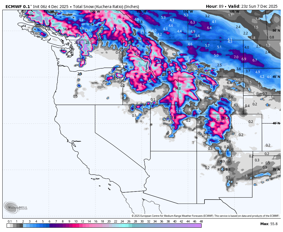
A potent northwest flow pattern is setting up to deliver a classic sequence of powder days across the American West. The action kicks off in the Pacific Northwest and Northern Rockies on Thursday and Friday, delivering heavy but denser snow to the Cascades and deep, high-quality cold smoke to Wyoming. As the energy digs southeast Friday night into Saturday, the bullseye shifts squarely to the Wasatch in Utah and the Northern Mountains of Colorado. This is an ideal chasing setup: hit the Tetons or Cascades Friday, then redeploy to Utah or Northern Colorado for the main event on Saturday. Expect deep storm totals, particularly in areas favored by northwest orographics, though winds will be a factor at exposed summits.
Please support your love of powder and our forecasts with a donation here, or join our concierge program.
KEY POINTS
The Good
A textbook northwest flow regime will maximize snowfall for the Tetons, the Cottonwood Canyons in Utah, and Steamboat in Colorado. Cold air accompanying this system in the Rockies will produce snow-to-liquid ratios (SLRs) in the 15:1 to 17:1 range for Wyoming and Colorado, creating genuine blower powder conditions. Utah will see slightly denser, surfy snow perfect for covering early-season terrain.
The Bad
The Pacific Northwest is dealing with a warmer air mass. While snowfall totals will be impressive (measured in feet), snow levels will fluctuate between 3,500 and 5,000 feet, and SLRs will hover in the 5:1 to 8:1 range, resulting in "Cascade Concrete." Additionally, strong winds gusting 40–60+ mph at ridgelines across the entire West could trigger wind holds and impact snow quality in exposed areas.
The Wildcards
The precise southern extent of the moisture plume in Colorado remains tricky. While Steamboat is a lock, resorts further south like Aspen and Crested Butte are on the fringe. If the jet digs slightly further south, the central mountains could overperform; if it stays north, they might just see dustings while the northern mountains get buried.
DAILY FORECAST

Friday Chase: Teton Cold Smoke & Cascade Depth
The best quality turns on Friday will undoubtedly be in Wyoming. Grand Targhee (opening day) and Jackson Hole are the primary targets. Grand Targhee is stacking up 8–10 inches Thursday night with another 2–3 inches during the day Friday, offering opening day turns in 10–13 inches of light, 16:1 powder. Jackson Hole will offer a similar 6–9 inch storm total. In the PNW, Stevens Pass (opening day) and Mt. Baker will be deep, with 10–15 inches of storm snow by the closing bell, but expect dense, wet snow (SLR ~7) and gusty winds.

Saturday Chase: The Wasatch & Steamboat's Big Day
The energy shifts south, making Saturday the premier chase day for Utah and Northern Colorado. In Utah, Alta (opening Dec 7) and Snowbird are the places to be. Expect a monster Friday night dumping of 9–14 inches followed by 3–4 inches during the day, totaling 12–18 inches of prime, supportive powder. Steamboat is the clear winner in Colorado, capitalizing on northwest flow to deliver 8–12 inches Friday night and another 4–6 inches Saturday day. You are chasing 12–18 inches of Champaign Powder here. Winter Park and Vail are solid secondary options with 5–9 inches of fresh snow.

Sunday Chase: Colorado Leftovers & Clearing Skies
Sunday is a cleanup day. Steamboat will likely harbor the best leftovers with an additional 3–6 inches falling Saturday night, bringing storm totals to nearly two feet. Winter Park and Copper Mountain will also offer soft turns with 2–4 inches of overnight refreshers. In Utah, the storm tapers off, but early risers at Solitude or Brighton might find soft pockets from Saturday night's 1–2 inch top-off before the sun comes out.
REGION-BY-REGION DETAILS

Northern Rockies (WY, ID, MT)
This region takes the lead early. A cold trough moves through Thursday night, slamming the Tetons with ideal orographics. Grand Targhee and Jackson Hole are looking at SLRs around 16:1 or higher, meaning the snow will be incredibly light and billowy. Temperatures will be frigid (teens to low 20s), preserving snow quality. Expect widespread 10–14 inch storm totals by Friday afternoon. Montana ski areas like Big Sky and Whitefish will see steady but lighter accumulations, generally in the 3–6 inch range, with gusty west winds scouring ridges.

Utah
This is a classic "northwest flow" event, which historically favors Little Cottonwood Canyon (Alta/Snowbird) and Big Cottonwood Canyon (Solitude/Brighton). The cold front slams into the Wasatch Friday evening. Friday night intensity will be high, with snowfall rates potentially exceeding 2 inches per hour. By Saturday morning, the Cottonwoods should sit on 10–15 inches of fresh snow. The snow density starts medium-weight (10:1) and lightens up by Saturday morning (14:1), creating that perfect "right-side-up" profile for effortless skiing. Park City and Deer Valley will see spillover but likely 30-40% lower totals than the Cottonwoods.

Colorado
The jet stream aligns perfectly for the Northern Mountains Friday night into Saturday. Steamboat is the obvious standout; the Park Range acts as a catch-mitt for moisture in this flow, creating localized heavy bands. While the I-70 corridor (Vail, Breck, Copper, Winter Park) will do well—likely in the 4–8 inch range by Saturday morning—Steamboat could double those numbers. The Central and Southern mountains (Aspen, Crested Butte, Telluride) will see significantly less accumulation as the flow is blocked by the northern ranges. Winds will be cranking out of the northwest, likely 20–30 mph with higher gusts, so look for wind-sheltered trees for the best experience.

Pacific Northwest (WA, OR, BC)
A warm, moisture-laden system is hitting the region. Snow levels are the headache here, hovering around 3,500–4,500 feet for much of the event before crashing later in the weekend. Mt. Baker and Stevens Pass will see impressive water content, translating to 12–20 inches of heavy, base-building snow through Saturday. Timberline and Crystal will see decent totals but battle high winds and fluctuating rain/snow lines. Whistler remains steady with moderate accumulations and cooler temps up high. This is a quantity-over-quality event for the PNW.
EXTENDED OUTLOOK
Looking into next week, the pattern remains active but warms up significantly. A strong atmospheric river is poised to impact the PNW and British Columbia early in the week, bringing heavy precipitation but rising snow levels. This moisture eventually pushes inland toward Idaho and the Northern Rockies by midweek, though it may come with denser snow or mixed precipitation at lower resort bases before cooling down again late in the week.


