OVERVIEW:
Blocking High Pressure is pushing the jet further north into Canada for much of this week. Northern BC and Alberta stand the highest chances of snowfall this week before dropping a bit further south by late this week. Snow will increase over Revelstoke and most of the Alberta resorts by Thursday. The Jet drops further south over the weekend or early next week bringing a good chance of snow back into Montana. Cold air stays north above the Rockies but swoops over New England late this week extending into the Southeast. North Carolina might reap some deep rewards in the mountain ranges by Friday. WOO HOO!
FORECAST:
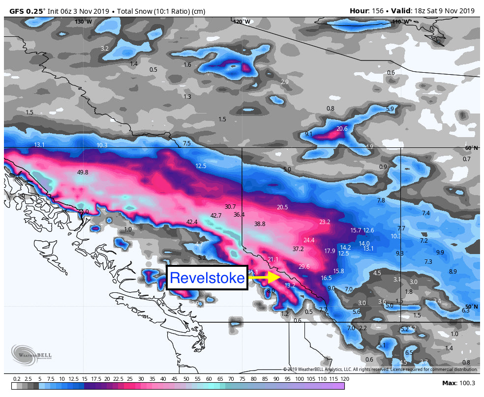
The Jet is pushing moisture north into Canada with low-pressure systems continuing to pump light snow and colder temps into BC and Alberta. Most of the moisture will feed north of Revelstoke and even Banff so amounts are not expected to be heavy (Slowly building with light snow each day this week). Moisture will ramp up somewhat by Thursday or Friday in BC with moderate amounts each day. Things might get skiable again by late in the week with amounts in the 6-12 inch range or more. (Totals for the week). Light snow will also be falling in northern Montana this week that should turn heavier by the weekend.
New England grabs light snow, cooler temps, and a taste of winter both on Tuesday and Thursday. Amounts will remain on the light side and be confined to the northern mountains.
Below: Colder air is pushed north this week dropping further south on Wednesday into Montana. The East coast grabs colder air that pushes into the Carolinas by Friday with snowfall. The majority of the west is under high pressure and warmer temperatures for much of the upcoming week.

Below: Total snowfall through Saturday for BC and Alberta. Ranges in northern BC will see the highest amounts. Peak snowfall may come Thursday or Friday.

The extended forecast may drop the jet further south with the Pacific Northwest Wildcard, and a higher chance for Montana scoring by Saturday or Sunday as mentioned above.
EXTENDED:
Models show some signals of moisture increasing for Montana for next weekend (Moisture drops further south by Saturday).
We noticed an interesting feature dropping into the Southeast late next week that might drop significant snowfall for the Carolina's (Ski areas). This deserves watching! This could be a decent snow event for the Carolina mountains.
Below: Low pressure with Northerly winds, cooler temps and likely snowfall for the Carolina Mountain ranges late next week. Image: Courtesy of Meteostar.

In the West, the ensembles show a buckle in the blocking high and a possible return of moisture for many regions, perhaps even the Sierra, PNW and Rockies at some point around November 12th. Lets hope that gives a wider area of the PNW, Rockies and perhaps the Sierra a chance of snowfall.

ANNOUNCEMENT:
Powderchasers is excited to partner with Hood River Distillers from Hood River Oregon. Hood River Distillers is going to give away ten individual price packs of thier appropriately named snow god \"ULLR\" Submit an original powder shot and hashtag #ULLRPOWDERCHASE for a chance to win an amazing swag price pack from @DrinkULLR and Powderchasers.
That includes all sorts of goodies, swag, etc. We have personally verified the high quality of ULLR! You will love the ULLR beanies and other swag that is included in the package. http://bit.ly/ULLRPowderChase. Offer expires on March 31st 2020.
Welcome to November!
Powderchaser Steve


