Summary:
In searching for deep pow, your only hope will be higher elevations of the Rockies initially Sunday-Tuesday. Cooler air moves into the Pacific Northwest and Rockies Tuesday/Wednesday with snow likely near the bases. Sum totals might be decent at the peaks.
Forecast:
The warm atmospheric river continues over the Pacific Northwest with temps at most ski areas well into the 40's and rain noted in most locations. Revelstoke snuck out a foot of snow on Saturday at the upper elevations.
Below: It felt really good to see Gnorm get fully buried (Revy snow cam) on Saturday. He is only 12 inches tall, but double digits are double digits. Rain fell at lower elevations. It looks like mid-winter in the background.

The best hopes of double digits in the next 5 days will be over the Tetons with a continuous fetch of moisture initially warm keeping snow above 9000 feet. Snow levels in the Tetons will drop by Tuesday night bringing some light snow to the Valley and another boost of better-quality snow for the mid and upper elevations of the Tetons (Cold Front).
Cooler air over the PNW will change rain to snow for most ski areas by Monday/Tuesday with perhaps 3-6 inches above 4500 feet. NW winds will favor ski areas from the central Cascades (Stevens Pass), and south through Oregon including Mt Bachelor. Baker often does best with SW flow so our hopes are slightly less. Moderate snow is also noted on the models for northern Idaho. Upper elevations will benefit the most, with much less at the bases (Schweitzer).
For the Rockies, if it were chase time, we would be heading to the Tetons where a continuous light to moderate snow continues Sunday/Monday at the summits of both JHMR and Targhee (Rain at the bases), slowly adding up (no real peak of any high intensity). As of Sunday morning, the temps are a balmy 29 degrees at the summit of JHMR and above freezing at most other weather stations. Hopes of rideable pow really don't come until Tuesday or Wednesday with the colder air. There won't be any single deep 24-hour event. As the cool air moves in quality improves, however moisture is also weaning.
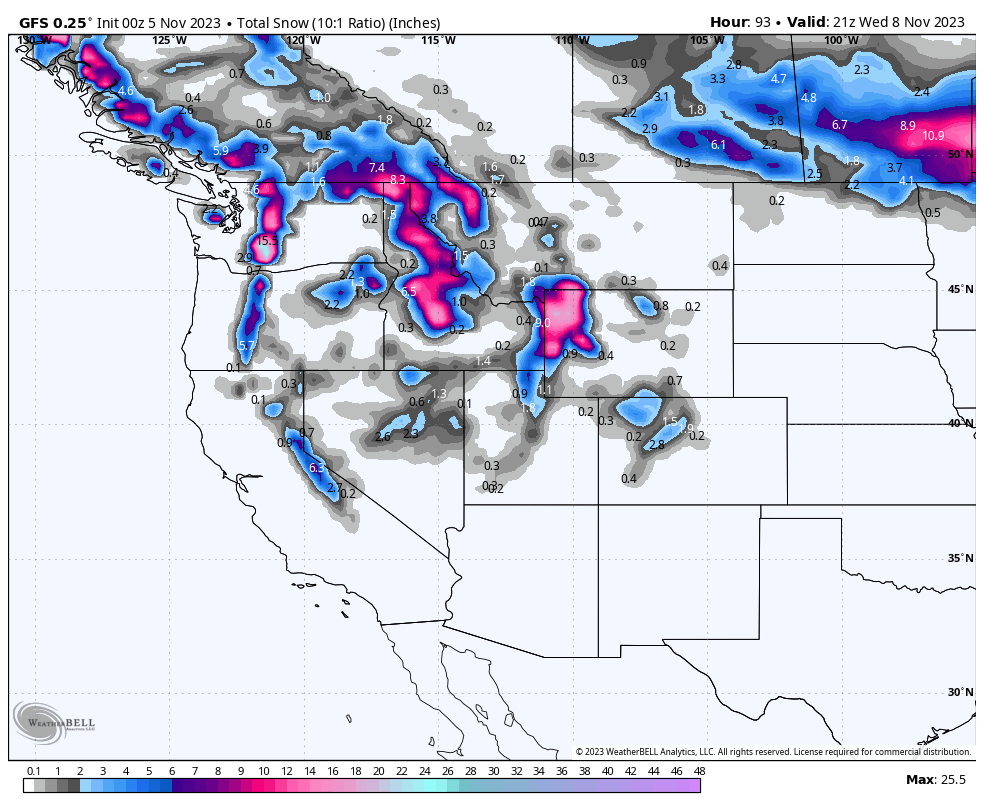
Below: Peak moisture totals will be found in the PNW with very warm temperatures initially (Rain) that take aim for the Cowboy State (WY) from Sunday night to Wednesday. Temps are warm in the Tetons until Tuesday night when a cold front brings some light snow to lower elevations. Snow totals will be very variable and elevation-dependent.

Below: The University of Utah ensembles (Multiple tweaks of 3 models) show a decent consensus of 12 inches from November 5 to the 8th for the upper elevations of JHMR. Most of this snow will be above 9,000 feet with cooler air bringing light snow to the Valley by Wednesday morning. There won't be any single deep event (Slow and steady moisture tap). Higher amounts are possible at the peaks. Wednesday offers your best opportunity as the snow levels drop but moisture decreases.

Moisture next week streams south to the highest elevations of the Sierra (Light snow is possible), northern Utah (Beaver Mountain and areas north are favored), and takes a better aim towards the Front Range of Colorado. It's possible that areas near the Divide including Berthoud Pass, Loveland, A-Basin, and most of Summit County, will score a moderate event in the Wednesday/Thursday timeframe. Caveat: The European models depict a decent event, whereas the American GFS is less optimistic for Colorado. This will need to be watched.
Below: Total snowfall through Wednesday morning next week. The amounts shown here will be highly variable elevation-dependent, and in some cases especially the PNW above the elevation ranges of some ski areas until early next week with cooler temps. Colorado is a strong wildcard with higher totals noted on the European model (Not shown).

Below: I am in Austria near Halstaat on Saturday driving through some low-elevation powder (700M). The Alps have had a fantastic start to the season. @powderchasersteve

Below: The Alps are looking amazing as the sun was out for just 3-5 hours in Gosau on Saturday before the next storm rolled in. @powderchasersteve via Instagram

You can follow my chases and passion for photos on Instagram @powderchasersteve
To support Powderchasers, please join our concierge program for 1:1 custom powder forecasts, and our expertise in sending you to the deepest resorts. This includes trip planning, contact with our forecasters and your dream vacation or desire to chase powder. You can also donate here. Please also visit our powderchasers store on the website. This all supports Powderchasers.
Powderchaser Steve


