Good morning powder lovers. This is Powderchaser Steve with a Sunday update for those of you looking to chase powder. The past few days have delivered big snow totals to the western BC resorts as well as the northern Cascade Ranges above 4,000 feet. Rain fell at the lower elevations of Whistler but from about mid-mountain and higher, it appears that approximately 18-22 inches fell from Friday to Sunday.
Sponsor Alert: "This post is sponsored by Skis.com and Snowboards.com. Powderchasers supports them being family-owned and with a vast selection of quality gear and clothing. Please check them out as supporters of this forecast and truly a fantastic product mix. We will donate a PC tee shirt for every purchase over $200 (Email us). They have an incredible selection. Please support them."
Pacific Northwest and Canada
Below: Buried snow cam on Saturday morning at Whistler (45 CM or 18 inches). More fell Saturday night into Sunday (Light to moderate)

Mt Baker in the northern tip of Washington has not reported totals. In looking at automated data (Snow telemetry) we estimate 18-20 inches at mid or upper elevations (4,200 feet and higher) with less at the base. Telemetry was not cooperating (Funk) but it's pretty likely some big totals fell there. Further south in the Cascade ranges much less snow fell.
Below: Telemetry from the Northwest Avalanche Center showed a bump from 3 inches to 20 on this last storm at 4200 feet at Mt Baker. Note, the erratic numbers below and above, so hopefully this 20 (Minus 3 from the starting point) of 18 inches is accurate. There is always discrepancy and no exact science to these numbers at times, but it's the best we have to judge totals right now. It's possible that there is much more at the summit.

Rockies:
Unfortunately, the Rockies have been stuck too far south of the action, with warming temperatures (60 in Salt Lake on Sunday). The long-term outlook for the Rockies shows a chance of some snow showers at upper elevations midweek (Nothing fancy) and a glimmer of hope of a stronger storm around November 20th. Temps stay warm.
Below: A storm is possible near November 20th for the Rockies favoring Utah/Colorado, and perhaps Wyoming. New Mexico or Arizona might also get into the action that week. It's too far out to forecast with accuracy.

Sierra "Boom or Bust"
Powderchasers has been tracking a strong system spinning off the coast of Northern California. The models early last week showed a very strong system and deep pow for the Sierra range. In the past 3- 4 days the models have downtrended snow totals keeping the highest moisture off and along the California coast. We support that theory, however, there is still some glimmer of hope for some areas.
Even just 3-4 days out, the models show very different timing. One shows the system pushing inland with light to moderate moisture beginning near Lake Tahoe as early as Wednesday night. Others show the system staying offshore and ejecting inland from south to north on Friday/Saturday. We don't expect significant snow totals at this point based on multiple model runs.
It's possible that the southern ranges near Mammoth fare better than ski areas closer to the lake. The storm will likely follow the coastal route and begin to push inland later in the week where areas will start to see snow above 8,000 feet. This is not a very cold storm. This storm could be a complete tease for many areas (The bust solution).
Below: The American GFS holds moisture off for inland areas until Friday/Saturday and pushes moisture north favoring southern regions. Lake Tahoe resorts would still see some snow (Light or moderate).

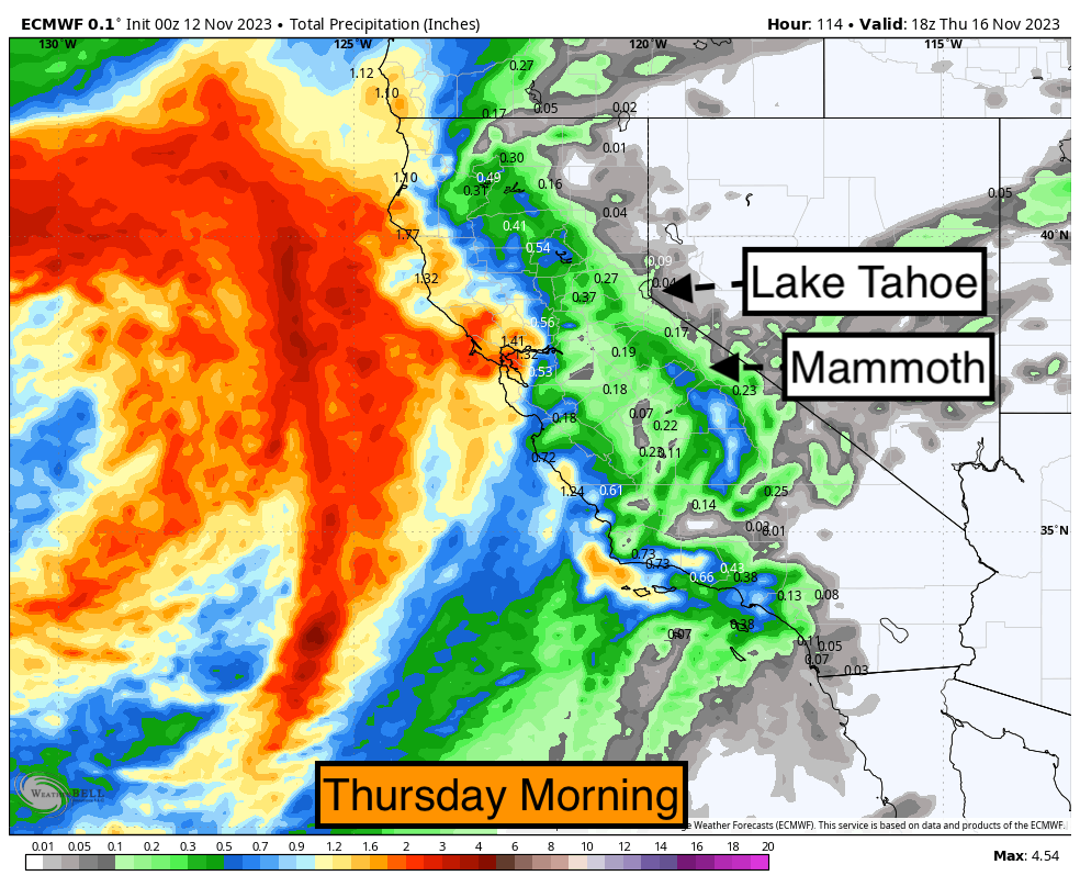
Below: The European models show moisture reaching Lake Tahoe by Thursday morning with very low amounts aside from a glimmer of hope near or south of Mammoth. You can see very heavy moisture off and closer to the coastal ranges.

Bottom Line: We will issue an update Monday or Tuesday with any new developments with the Sierra storm. There is still poor model consensus, especially on timing. Moisture totals are on the downtrend for inland areas. Southern areas are likely to fare better above 8,000 feet. Let's hope the models start to resort back to a more bullish solution (Ensembles are still optimistic).
Alaska. The headlines of the week are areas of southeast Alaska that scored 40-65 inches of snowfall. Alyeska based on telemetry scored 40-50 inches (Mid to upper) and 30 inches at the base. It is possible these totals are higher. Thompson Pass near Valdez and our partner Alaska Backcountry Guides (Heli) likely saw 60-80 inches. Check out Alaska Backcountry Guides for our promotion of unlimited vertical in March plus a free concierge membership from our forecast team (Custom forecasts 1:1) for the season. Snow will continue in several light or moderate clips for the upcoming week perhaps a bit heavier next weekend. Temps remain cold.
Below: Girdwood AK at the base of Alyeska was digging out on Saturday. Photo: @tylerschmittak907 via Instagram.

Below: Additional snowfall for Alaska for the upcoming week. The highest totals will fall toward Thompson Pass and Valdez. Alyeska will see 9-14 additional inches during the upcoming week with low snow levels.

ANNOUNCEMENT: Please join our concierge program to support powderchasers. This program provides 1:1 forecasting, chase locations, and custom trip planning to get you in the deepest snow of the season. You can also donate on our website or purchase some swag to support us.
You can follow my passion for travel, photography, and powder on Instagram @powderchasersteve
Enjoy the powder, everyone!
Powderchaser Steve


