
Short Term Forecast
Utah wildcard:
We are not at a Powder Alert, but it's possible that the Central Wasatch (BCC and LCC) sneak up some moderate totals Wednesday evening (5-9) above 9,000 feet The Uinta Range will also score decent snowfall at upper elevations. SW flow initially keeps temps very warm on Wednesday with a slight cooling trend for Thursday morning (Snow level drops to 7500 or 8K). BCC is generally favored with SW flow (upper peaks of Solitude or Brighton). Any lower elevation resorts will likely see very little snowfall. Bottom Line: Its a bit of a long shot, but it can certainly put down some moderate cream up top. This is energy spinning up from the California coast combining with a bit of cooler air from the north with very high snow levels (Get up early to skin up high).
Below: Short term high resolution model showing an increase of snowfall for Utah late Wednesday night especially the Cottonwoods (Upper elevations). It's still a bit of a wildcard and only at upper elevations. Other models are less bullish.

Chase to northern Montana?
Montana will also see moderate snowfall in the northern portions near Glacier National Park and even Whitefish (Summit). Some moderate amounts are also showing up on models for the northern Panhandle of Idaho near Lookout Pass (Wildcard) with high snow levels (Above the bases). Higher elevations of glacier National Park might score 5-10 inches with Whitefish seeing less.
Below: Some moderate snowfall is likely for northern Montana, especially the eastern edges of Glacier National Park. Whitefish and even Lookout Pass (Idaho) also could see some light or moderate totals at upper elevations. Peak intensity will be Wednesday PM to Thursday AM.

It's generally a boring pattern for most areas of the west until late this weekend when a very cold airmass overspreads the west increasing the odds of some lower elevation powder. This will be the coldest air of the season and will bring some lowland snowfall to valleys. Temps will plunge into the single digits for many mountain locations next week with some snowfall.
Friday-Monday Forecast
Sierra Snow
The low that has been spinning over the waters of California will finally start to move inland with decaying moisture for the Sierra. Some moisture will begin as early as Thursday and continue again for the Friday night/Saturday range. Amounts could exceed 5-7 inches towards Mammoth or southern areas of the Tahoe Basin above 9,000 feet (Very high snow levels). The Tahoe Basin will see light rain with generally lighter snow totals. The Sierra Crest may outperform slightly, but overall it's a weak storm with light precipitation spread out over several days peaking Friday/Saturday.
Cascades- late weekend storm
The Cascades have some odds of moderate or perhaps deeper pockets from the central regions near Stevens to Mt Baker, with a bit less in the southern areas of Washington. Temps are warm initially Saturday night (snow levels 4500 to 5K) with rain at lower elevations turning to all snow by Sunday morning. Temps cool significantly behind the front with a continued chance of snow showers Sunday. Its possible some upper elevations grab 5-11 inches by Sunday mid morning (Mid or upper elevations). I have less confidence for the southern zones of Washington or Oregon. Be prepared for any surprise totals Sunday morning especially up north.
Below: Temps in the Cascades are warm Saturday night (5,000 foot snow levels) until a colder airmass arrives Sunday morning driving lower elevation snow (Moisture is split between falling during the warmer phase and colder phase). Map- 4800 feet showing 1-2C in most areas. Some decent upper elevation totals are possible by Sunday mid morning, especially the northern Cascades (Summit of Baker). Stevens Pass is a solid wildcard (mid or upper elevations initially).

Rockies- Cold front- Snowfall Sunday-Monday - More exciting.
The coldest air of the season will be dropping down from Canada late this weekend into early next week. Models diverge on who will see the highest snow totals. It is a quick moving front, but could land some decent totals, especially for northern Utah and most of western Colorado. Snow to liquid ratios will be high so upside surprises can outperform the 10:1 model data.
Below: The European models show the cold front well entrenched over Utah and the gut of the Rockies by late Sunday night.

Below: The American model shows the cold front slightly east of Utah more focussed on areas north or along the Continental Divide including Western Colorado. This might bring less snow to Utah and Idaho with higher amounts over Colorado.

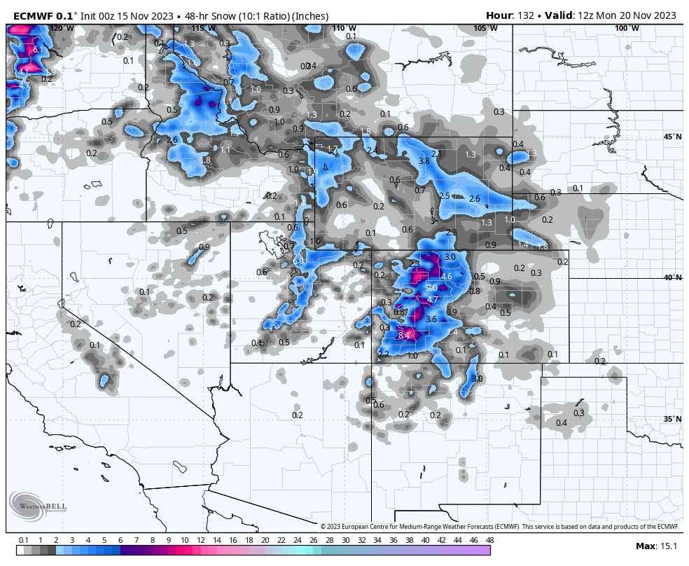
Below: It's too early to speculate on totals. Here are 48 hour snow totals that might overspread the Rockies from Sunday to Monday. We think Colorado has some upside based on this model with a bit more of a quick hitter for areas north or west. The American model (Not shown) is much less optimistic. We need time to narrow in these totals.

Below: U of U ensembles showing a wide spread of solutions (Low confidence with such a wide spread of lines) for some decent snowfall for Vail pass late this weekend into next week (11-19/11-20). Our initial forecast is in the 5-10 inch range but that is likely to change as models update closer to the weekend. This could over perform and even bust but it's less likely.
 ANNOUNCEMENT: Please join our concierge program to support powderchasers. This program provides 1:1 forecasting, chase locations, and custom trip planning to get you in the deepest snow of the season. You can also donate on our website or purchase some swag to support us.
You can follow my passion for travel, photography, and powder on Instagram @powderchasersteve
Enjoy the powder, everyone! It's still too early to make any predictions on who will see the deepest snow this winter. It has certainly been warmer than average with most moisture contained to the northern PNW, Canada and Rockies.
Powderchaser Steve


