
A mild early-week system sprinkles in light to moderate snow across parts of the Northwest and the northern Rockies. By midweek, colder air and a more potent storm spread decent accumulations in the Sierra and across the Great Basin into Utah. Then the real fireworks arrive late week for the Wasatch and southwestern Colorado, with the weekend culminating in a potential deep event at Whistler. Snow levels generally hover in the mid to upper elevations initially, then crash with each cold front, setting the stage for fluffier storms in many spots. Wind direction shifts—especially NW flows—will drive orographic enhancements. Expect best conditions from midweek onward in many areas, especially Thursday and Friday in Utah/Colorado and Saturday/Sunday in far northern ranges like Whistler.
NOTE: Powderchasers is excited to announce the "powder guarantee". This add-on to our concierge package guarantees that you will not pay for a "chase" unless we deliver on 50% of the forecasted snow. So how does it work? Purchase our two-chase package plus insurance add-on, then when you are within seven days of your target day in a specific ski region we guide you to the deepest powder in that region or we give you the heads-up that there will not be any significant snowfall for your trip. If we fail to deliver on our powder forecast by less than 50% you get another chase free of charge. Example: we guide you to Tahoe for the 10th of the month and predict 15" of pow, if they get 7 1/2" or less on the 9th, 10th or 11th; then you get another chase on us.
Chase Forecast
-
Tuesday (3/4):
Light Powder Day in southern Utah (Eagle Point snagging leftover snow from Monday night). Modest fresh in parts of CO (Steamboat, Vail) from the overnight. -
Wednesday (3/5):
Chase CA in the afternoon/evening as snow ramps up in Tahoe (Kirkwood, Mammoth, Sugar Bowl) and around Mammoth. Not much fresh accumulation. -
Thursday (3/6):
Utah’s Cottonwoods (Alta/Snowbird, Solitude/Brighton), as the storm cranks out double-digit totals with great SLRs. Colorado mountains (especially Wolf Creek, Telluride) start seeing new snow, but not much accumulation yet. -
Friday (3/7):
Utah continues to see lingering fresh (Wasatch resorts easily stacking into the foot-plus range). SW Colorado (Wolf Creek, Telluride) also accumulates good totals, with potential for 9"+. -
Saturday–Sunday (3/8–3/9):
Run for Whistler! They could reel in 10–20+ inches by Sunday, but SLRs will be dense at mid-mountain (8–10, higher at upper elevations). This spells a deep weekend up north, but a little on the heavier side. Some CO resorts (especially Wolf Creek) may still be picking up leftovers—though not as big as earlier in the week.
The Good, The Bad, and The Wildcards
-
The Good:
Colder air and higher snow-liquid ratios in Utah and Colorado, meaning blower potential. Deep multi-day totals at Whistler and the Wasatch. -
The Bad:
Intermittent rain or mixed precipitation at lower PNW elevations, plus some dryness midweek for many WA/OR spots. Gusty winds could hit exposed ridges in CA and UT, possibly causing some lift closures or wind holds. -
Wildcards:
NW flow enhancements in the Wasatch or southwestern Colorado might boost totals beyond the forecast. Model discrepancies about how moisture surges into the Cascades late in the weekend—some areas may score bigger than expected.
Forecast Discussion – Region by Region
Pacific Northwest (PNW)

Overview: Early-week precipitation is generally light, with snow levels around 4000–5000 ft. A mild wave on Tuesday brings a few inches to areas like Timberline (1–3" total). Then a brief lull for midweek.
Mount Baker: Light snow (1–3") Tuesday night into Wednesday, then again Fri night through Sunday with a potential 4–9" new by Sunday. Snow levels hover a bit high at times, watch for slightly denser snow.
Whistler: Modest early in the week (1–2"), then a bigger wave from Fri night onward with 10–20+ inches possible through Sunday. SLRs around 8–10+ means some solid powder—best bet in the PNW heading into the weekend.
California

Tahoe Region (Heavenly, Northstar, Palisades, Mt Rose, Kirkwood, Sugar Bowl): Expect new snow Wednesday into Thursday, with totals ranging from ~2–5" at the lower end (Northstar, Sugar Bowl) up to about 7–12" at Kirkwood. SLRs look fairly healthy (12–15+), so quality should be decent. Storm wraps up by late Thursday, leaving a possible powder day on Friday.
Mammoth: Could see 8–14" by late Thursday night. Temperatures and SLR favor some lighter powder on top but watch for heavier snow at the start.
Short Dry Break: A break emerges Friday into Saturday, then some uncertain moisture tries to creep in Sunday, mainly north of Tahoe. Another potential storm incoming Sunday/Monday, stay tuned.
Utah

Early Week (Mon–Tue): A minor system drops a few inches across the Cottonwoods (2–4" Solitude/Brighton, 3–4" Alta/Snowbird). Northern resorts like Beaver Mtn and Powder Mtn also get a couple of inches. Eagle Point in the south does surprisingly well Monday into Tuesday with ~4–6".
Mid-Late Week (Wed night–Fri): This is the big one. The Wasatch lights up, especially Thu–Fri. Alta/Snowbird could see 12–21", Solitude/Brighton 11–20". Beaver Mtn and Powder Mtn also 6–16" range. Snowfall rates get an extra kick from SW to NW flow transitions, so watch for sneaky big totals in favored canyons. SLRs in the mid-teens indicate fluff factor.
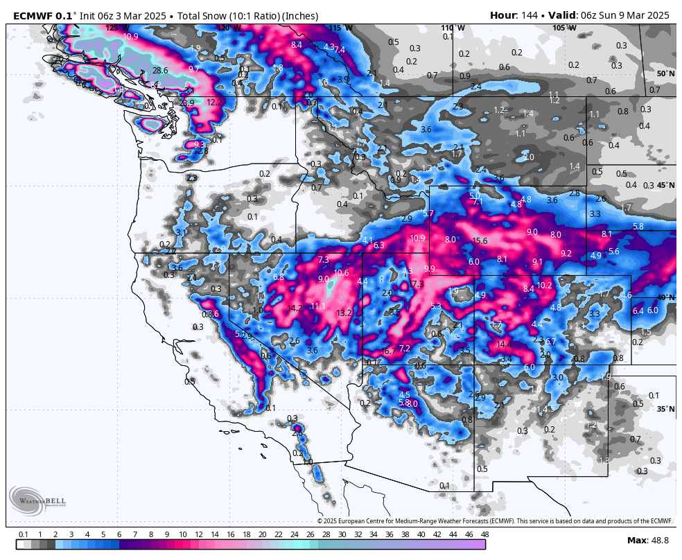
Colorado

Above: ECMWF snowfall through Wednesday morning.
Early Week (Mon–Tue)
Widespread moderate snow across many mountain zones. Totals by Tuesday night:
- Steamboat: 4–7"
- Vail/Beaver Creek: 6–9"
- Loveland/A-Basin: 5–8"
- Telluride: 5–7"
- Snowmass: 4–7"
Late Week (Wed/Thu–Sat):
Additional shots arrive for southwestern CO and the central mountains Thu–Fri. Wolf Creek may see 9–18" from Wed night to Fri night. Telluride also looks strong with ~4–8". The central and northern zones (Steamboat, Winter Park, Copper) see smaller but still respectable accumulations in the 4–8" range. SLRs are high (15–19), so expect quality fluff. Below: ECMWF snowfall through the second storm (both storms combined). These totals are likely significantly under-forecasted, since it assumes an SLR of 10:1, but real SLRs will likely be 1.25-1.75x higher!

Extended Outlook
Looking beyond the weekend, high pressure might briefly build over parts of the West, but there’s growing confidence in another pattern shift that could push additional storms into the Pacific Northwest and Rockies. Keep an eye out for potential back-to-back systems heading into the second week of March.
Bottom Line
- Midweek chase in Tahoe (Wed–Thu) and the Wasatch (Thu–Fri) looks excellent.
- Late-week in Southwest Colorado (Thu–Fri) for deeper accumulations.
- Weekend run to Whistler if you want to score 1–2 feet.
NOTE: Please support Powderchasers with a donation, merchandise purchase (such as a hat or stickers), or sign up for our custom Concierge Powder Forecast Package, where we provide 1:1 phone & email support to get you to the deepest locations possible. When chasing snow, the Concierge gets you the very best intel. Sign up for our free email list so you never miss a powder day. We are also seeking new sponsors and ambassadors who want to submit photos and videos; please reach out for more information.


