
The mountain bikes are out today, and record-setting temperatures are in many areas of the West. The next stormy period begins in the Sierra on Sunday and aims for the central Rockies. Two more systems will take a similar path next week, eventually moving further south, with the four corners as a possible target. Cold air will accompany these fronts, and snow levels will be below lake level in Tahoe.
SPONSOR ALERT- Support our smaller core ski areas
INDY PASS GOES ON SALE TODAY FOR A LIMITED TIME FOR THE PUBLIC
Today: March 1- Indy Pass on sale now $349 Adult, $199 kids 250 resort guarantee with the addition of 5 new areas including the southern hemisphere (Chile)
Here are a few snowfall totals Powderchasers expect through Tuesday next week with storm #1
Palisades: 3-7 inches
Kirkwood: 4-8 inches
Mammoth: 5-9 inches
Powder: 7-14 inches
Beaver: 4-8 inches
Alta: 7-12 inches
Park City: 5-10 inches
Brian Head: 5-11 inches
Rocky Mountain National Park: 6-14 inches
Estes Park: 6-12 inches
Winter Park: 4-10 inches
Breckenridge: 4-9 inches
Vail: 4-8 inches
Aspen: 3-7 inches
Telluride: 4-8 inches
Crested Butte: 1-3 inches
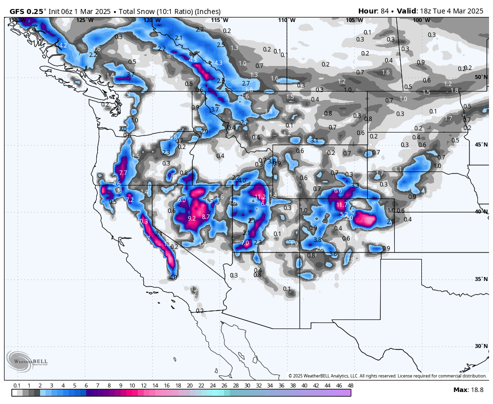
While looking at multiple models on Saturday morning, enough differences led us to issue some questionable totals, especially in Utah and Colorado, where some spots have a wide range of solutions (6-18 inches). We compared the short-term NAM, Euro, GFS, and Canadian, and there are vast differences.
Bottom Line Summary:
The Sierra grabs a moderate storm (4-8) on the west side of Lake Tahoe, with some odds of higher totals further south toward Mammoth. The timing is a bit combined with day snow on Sunday and some leftovers on Sunday night (Mammoth Peak opening Monday could be a good score). Models range from 5-10, with some showing 3-7 (some risk in this chase). Not huge numbers, but good quality.
Utah has high confidence of 5-12 inches in the southern mountains on Monday/Tuesday.
The northern mountains will gather confidence for 7-17 inches (Upper-end wildcard), with a toss-up between the Cottonwoods or even further north towards Ogden (Models disagree). Short-term and European models are less optimistic for northern Utah, offering lower totals. There is some boom-and-bust potential. It is a safe bet to go with 7-11 inches for most of the Wasatch Range with definite boom and bust potential (NW flow Monday PM can enhance some totals into Tuesday). Most of the powder will happen Sunday night to Monday.
Colorado has been more consistent in model data, showing the highest totals falling in northern Boulder County, especially over Estes Park (8-15) and perhaps the Fort Collins or RMNP region. A few models push the higher totals east of all of these regions over the plains.
Most models, including Summit and Eagle Counties, agree on some moderate snow (5-10). These areas may grab higher amounts per the European model (7-11 for Summit and perhaps higher amounts north of I-70). High confidence exists for lighter totals towards Aspen and south into the southern mountains where 3-7 inches is possible. Telluride can also score with low moisture but NW winds. New Mexico gets teased.
The Tetons are north of the highest moisture but might grab some light snow by Monday. Areas south of Jackson toward Cokeville might see higher totals.
Below is a breakdown by region with details.
CALIFORNIA
Below: Cold front pushing snow levels below lake level by Sunday morning. This will be one of the colder storms for the Sierra in a while.

Below: We are in range for the latest Short Term models showing 5-10 inches on the HRR for the Sierra Ranges. Timing: Sunday storm ski. New openings on Monday.

Below: The short-term NAM is meager (3-6) near the lake, pushing moisture south. Even this map that shows a possible 7-11 inches south may end up just west of Mammoth (Boom or bust).

UTAH
Below: For the remainder of the west, comparing the NAM short-term model on the left with the American GFS on the right, there should be decent totals for southern and northern Utah. The NAM shows lower totals for northern Utah (5-10), while the GFS (Right) is bullish for 10-18 inches but pushes those totals north of I-80 toward Ogden. The European model (Not shown) is much less optimistic. Bottom Line: There is an outside chance of 10-18 inches setting up somewhere from the Cottonwoods to perhaps Powder/Snowbasin. Bust potential is possible if you believe the European model and some short-term models (4-9). Timing: Sunday night to Monday, storm ski, and good NW flow for additional snow on Tuesday morning. Bottom Line: Good confidence in 6-11 inches for many mountains in the Wasatch, including Beaver, and the northern areas towards Ogden. Upside possible through late Monday night.

COLORADO
Below: The European Model shows higher totals north of Boulder, moderate totals near the Divide, and west to Summit and Vail. Higher totals are possible near WP or north to Estes Park. There is some bust potential, with a few models keeping most moisture north and east. Timing: Good overnight snowfall Monday night. NW flow can benefit Summit County, Vail, and Telluride (Lower moisture south).

EXTENDED POW
We are entering an active period. A few more storms are tracking into the Sierra starting early next week, and another system will arrive later. They all appear cold.
Below are 24-hour snow totals ending Thursday PM, March 6th. This midweek storm could be another good event for Utah and Colorado. It also edges further south into the San Juan Range. This is your midweek storm.

Below: Another storm might move south later next week on March 8 and bring higher totals into Arizona and New Mexico (Finally). This is too far out to be confident, but a bit of eye candy can't hurt. The PNW and BC might also begin to see some action.

We need your help to keep these forecasts going! Dont Forget Indy Pass goes on sale today.
NOTE: Please support Powderchasers with a donation, merchandise purchase (such as a hat or stickers), or sign up for our custom Concierge Powder Forecast Package, where we provide 1:1 phone & email support to get you to the deepest locations possible. When chasing snow, the Concierge gets you the very best intel. Sign up for our free email list so you never miss a powder day. We are also seeking new sponsors and ambassadors who want to submit photos and videos; please reach out for more information.
Powderchaser Steve @powderchasersteve via Instagram.


