
SUMMARY
A midweek storm trains its sights on the Sierra and the Wasatch before drifting into Colorado. The PNW stays relatively quiet beyond a few light showers. Northern California resorts pick up moderate totals through Thursday, but Utah’s Cottonwoods are the big winners, primed for 1–2 feet of increasingly blower pow (conservative forecast, totals will likely easily exceed that range). Colorado sees modest-to-moderate snowfall through Friday, especially in the southern and central mountains. Bottom line: Keep your eyes on Utah for the deepest turns!
DEAL ALERT: The Mountain Collective Pass, the world's premier multi-mountain pass, is back for the 2025-2026 season—uniting 26 of the most iconic ski destinations and providing flexible access at an unbeatable price. With two days at each resort, unlimited half-off additional days, and no blackout dates, The Mountain Collective lets you chase the best snow at your favorite mountains all season long. Buy your pass by April 27th and enjoy two exclusive benefits: a bonus 3rd day at the resort of your choice and special renewal rates available for returning passholders. Renew now for $639 and secure your bonus day!
Table of Contents
CHASE FORECAST
Thursday (3/6)
-
Utah (Wasatch Front)
Overnight Wednesday plus Thursday daytime combine for 10–14 inches (locally more) at the upper Cottonwoods (think Alta, Snowbird, Brighton, Solitude), with snow quality improving as temps drop. Early Thursday offers a sweet window—go get it before midday crowds. -
California (Sierra)
Resorts like Mammoth could total 7–9 inches by Thursday morning (from Wednesday’s storm) with an extra inch or two during the day. That’s enough for a fun chase, especially if you like denser-but-not-heavy pow (SLR ~11–15). Further north around Sugar Bowl and Palisades Tahoe, expect 4–8 inches by midday Thursday. Go early for freshest tracks.
Friday (3/7)
-
Utah
Another overnight dose hits the Wasatch—5–8 inches from Thursday night into Friday daytime. Combined with Thursday’s leftovers, that means a two-day party of deep, increasingly fluffy turns. Winds may pick up in spots, so watch for drifting higher up. -
Colorado
Storm impacts ramp up from Thursday night into Friday. Wolf Creek could score around 7–10 inches by Friday morning (counting Thursday + Thursday night), with SLR pushing well above 12:1 for fairly light pow. Crested Butte and Snowmass also see freshies in the 4–7 inch range by day’s end Friday. It won’t be huge, but coverage is decent, and quality should be solid with cooler temps.
Saturday (3/8)
-
Colorado
A few lingering accumulations overnight into Saturday (mainly 1–3 inches in spots like Wolf Creek), but no major new dumps. If you’re already on location, you’ll find leftover fresh, but the storm is winding down. -
PNW & California
Generally dry and mild. Not worth a dedicated chase unless you’re aiming for sunny groomers or leftover scraps.
Beyond Saturday
- A longer-range system is brewing for early next week (especially in California’s higher elevations and the central/southern Sierra). We’re not ready to call a chase yet, but it’s worth keeping on your radar. A few moderate accumulations each period could stack up to something more substantial by midweek.
KEY POINTS
-
Good:
- Utah’s Cottonwoods get hammered with increasingly high-SLR snow (turning blower).
- Mammoth and the Central Sierra pick up moderate storms midweek with improving quality.
-
Bad:
- Gusty winds in Utah and Colorado could create drifted or slightly crusty ridgelines.
- Lower elevations in some Sierra spots still see some denser snowfall early on.
-
Wildcards:
- Next week’s storm track could steer major moisture into the Sierra and Intermountain West—stay tuned.
REGION-BY-REGION DETAILS
Pacific Northwest (PNW)
Mostly quiet after scattered showers Wednesday. Snow levels around 3000–4000 feet keep the Cascades dusted with 1–3 inches but nothing huge. Dry, mild weather locks in Thursday through the weekend. Whistler sees decent accumulations Friday night through Monday, but overall totals come with mixed snow densities (SLR 7–10 range). No major chases recommended here.
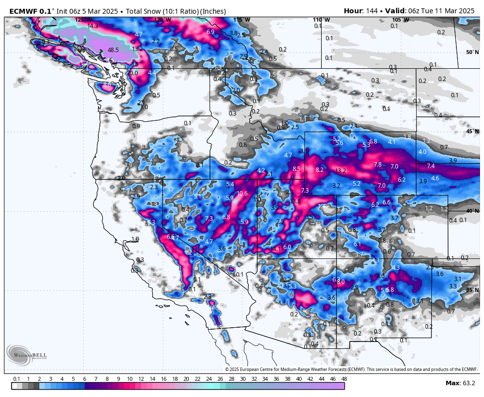
California

Above: snow through Friday night for California. These numbers are slightly too conservative, since this map assumes a 10:1 SLR (they will be around 1.25x higher in reality).
- Tahoe Region: Wednesday into Thursday brings moderate snowfall (4–8 inches) at resorts like Sugar Bowl, Palisades Tahoe, and Northstar. Snow ratios look respectable (around 9–14:1), so conditions should be playful but not pure blower. Dry conditions follow Friday into the weekend with sunny skies.
- Mammoth: Picks up around 7–9 inches by Thursday morning, plus a bit more through Thursday night. Some of that hits 15–17:1 SLR, so expect lighter pow on top. After a quiet weekend, another system could arrive Monday into Tuesday.
- Kirkwood & Heavenly: Similar story—roughly 6–10 inches through Thursday, high SLR for the late-phase snow. Locally heavier bursts are possible if any convective cells pop up. Watch Monday for a possible refresh.
Utah

Above: ECMWF QPF through Friday night, favoring the Cottonwoods.
- Wasatch (Alta, Snowbird, Brighton, Solitude): The standout winners. From Wednesday night through Friday night, total accumulations could hit 1–2+ feet, especially in the upper Cottonwoods. Early snow (Wed night/Thu) has moderate SLR ~9–11:1, then transitions to 14+ overnight Thursday and Friday, delivering blower conditions.
- Park City/Deer Valley: 10–15 inches total by Friday. That’s no slouch, though slightly lower SLR means slightly denser snow to start.
- Powder Mountain & Beaver Mountain: Expect around 10–16 inches by Friday. Higher SLR Thursday night onward should yield quality pow up north.
- Eagle Point: Could see around 1+ foot from midweek storms, with especially fluffy snow (SLR 15–17) Thursday night into Friday.
Colorado

Above: snow through Saturday for Colorado. These numbers are far too conservative, since this map assumes a 10:1 SLR (they will be 1.25-1.75x higher in reality).
- Southern Mountains (Wolf Creek, Telluride): Wolf Creek snags 7–10 inches by Friday morning, then a bit more Friday night into Saturday (1–2 inches). Telluride sees lighter amounts (3–6 inches by Friday morning).
- Central Mountains (Crested Butte, Snowmass): Expect 5–9 inches total by Friday, favoring the higher peaks. Friday morning rides could be decent after the overnight bursts.
- Northern Mountains (Steamboat, Winter Park, Loveland, A-Basin): Generally in the 4–8 inch range between Thursday and Friday night. SLR near or above 14:1 at times, so the fluff factor will be good—just not huge totals.
EXTENDED OUTLOOK
High pressure breaks down early next week as another Pacific trough moves inland. California stands to gain more moderate-to-heavy snow by Monday/Tuesday, with that system potentially swinging into Utah and Colorado around midweek. Keep the chase gear handy—more powder days may be on the horizon!
NOTE: Please support Powderchasers with a donation, merchandise purchase (such as a hat or stickers), or sign up for our custom Concierge Powder Forecast Package, where we provide 1:1 phone & email support to get you to the deepest locations possible. When chasing snow, the Concierge gets you the very best intel. Sign up for our free email list so you never miss a powder day. We are also seeking new sponsors and ambassadors who want to submit photos and videos; please reach out for more information.


