My last powder day was at Crystal with 13 inches overnight for Wednesday. In searching for powder, the only options are for light snow in the Wasatch that is looking more like a dud in today's model runs, or perhaps send it to Oregon where 3-7 inches is likely for Friday along the Cascade Ranges. That might be the most optimistic chase with decent snow levels.
Below: Friday AM will bring light to moderate amounts of powder to most of the Oregon Cascades.

Below: Crystal Mountain last Wednesday morning - @powderchasersteve via Instagram.

Colorado grabs low-pressure late Friday night into Saturday with snow falling east of the Divide. The models show the ski areas will be receiving light snow for this storm with a few exceptions possible near Berthoud Pass where 1-4 inches is possible. For the most part, it's a storm that is only going to coat or slightly refresh the surfaces below. Can we say \"boring\"? The latest models as of 8 AM Friday show anything from 0-4 inches closest to the Divide. Perhaps Berthoud Pass gets lucky but it won't be deep. Wolf Creek will be just west of the best moisture with perhaps light snow by Saturday mid-morning. Stay closer to the Divide and if lucky you might wake up to more but I am not confident.
Below: Precipitation amounts for Colorado Saturday favoring areas east of the Divide and a near bust west of the Divide.

New Mexico gets into the action for late Saturday to Sunday. Snow will be ramping up in New Mexico with easterly upslope winds that are not ideal for most ski areas. Angel Fire is east of Taos so may pick up 2-6 inches with Ski Santa Fe also a wildcard that sometimes benefits from upslope storms. I would expect 2-6 inches of fresh powder for your first turns on Sunday at these resorts. Taos may see slightly less. Conditions will be soft and it will still be snowing for your 1st chairs on Sunday.
Below: Light or moderate snow likely for NM resorts favored in Easterly Flow.

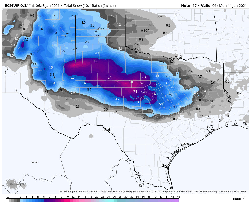
This storm drops south edging over Ski Apache near Ruidoso NM before setting over Texas. Ironically, some areas of Central and West Texas are likely to see the highest amounts. Aim to ride the streets of Midland or Lubbuk with 4-8 inches likely in these areas.
Below: Texas may see decent amounts!

The extended forecast brings a very wet period back to the Pacific Northwest. light snow will be falling over the Washington Cascades on Sunday with colder temperatures. Moderate or heavier snow is possible for the northern sections near Mt Baker that could continue into Monday morning. Temps are chase worthy on Sunday however, warm on Monday. Timing will be important to grab this moderate system before it gets warm. The ongoing models beyond Monday show moisture continue in the PNW with a warming trend. This will likely bring some rain to lower or mid-elevations mid next week.
High pressure over the Rockies may extend into the 3rd week of January. Let's hope for a pattern change by the end of the month.
Powderchaser Steve


