
A multi-wave storm cycle will sweep across the West over the next week, bringing fresh snow in phases and refreshing conditions repeatedly if you plan your chases right. Light to moderate snowfall is already arriving in Washington and Oregon, with heavier pulses headed for the Oregon Cascades, the northern Sierra, and points farther inland. By the weekend, cold air will seep deeper into the Interior West, sustaining quality conditions long enough for adventurous skiers and riders to find several tasty windows of powder.
This post is sponsored by Alaska Backcountry Guides, which offers fantastic heli skiing out of Valdez. This area just picked up multiple feet of powder in the past five days. Alaska Backcountry is our preferred Alaska partner and has limited seats. Mention powderchasers when booking and receive a free concierge package from us, which will be good through next season. More snow is on the way for Alaska.
NOTE: Please support Powderchasers with a donation, merchandise purchase(such as a hat or stickers), or sign up for our custom Concierge Powder Forecast Package, where we provide 1:1 phone & email support to get you to the deepest locations possible. When chasing snow, the Concierge gets you the very best intel. Sign up for our free email list so you never miss a powder day. We are also seeking new sponsors and ambassadors who want to submit photos and videos; please reach out for more
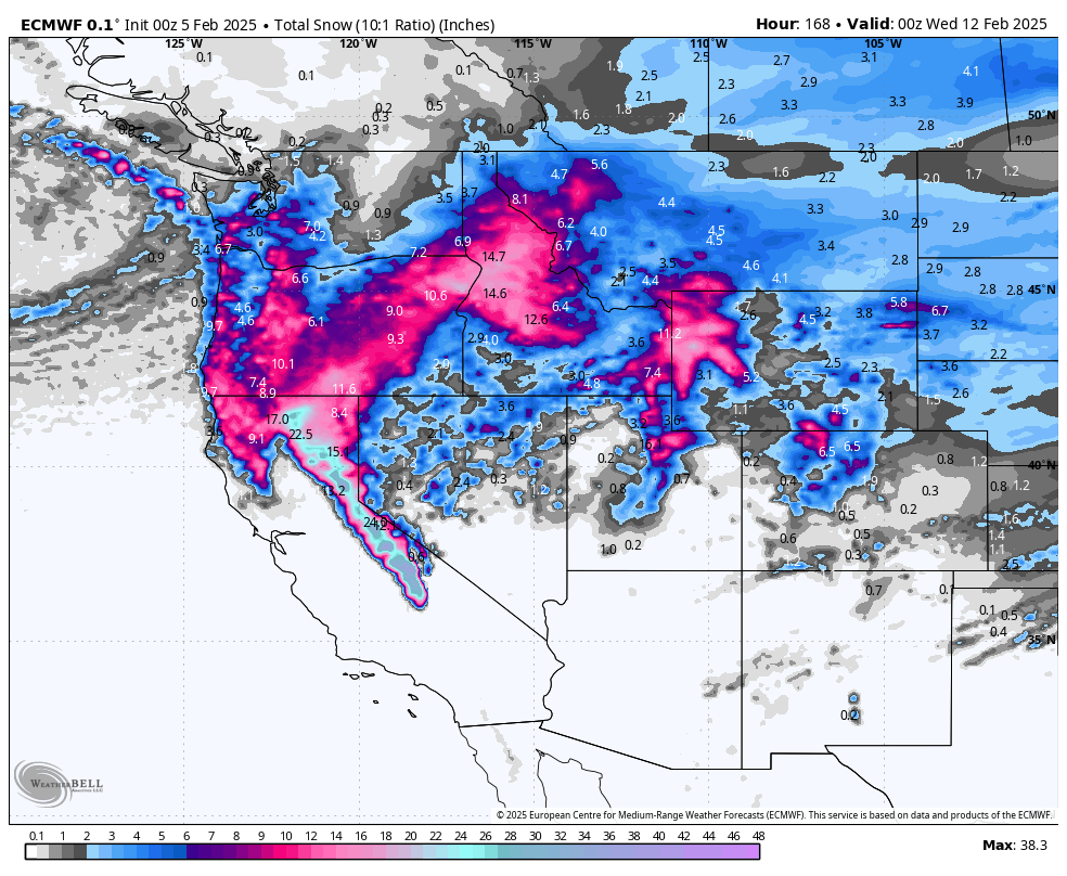
In the Pacific Northwest, Mount Hood and surrounding Oregon peaks are front and center. Timberline, for instance, could stack up 18–31 inches total through early next week, with about 5–9 inches from the midweek wave and another 13–22 inches arriving Friday into Tuesday. Mt Bachelor also looks poised for strong totals, with 16–30 inches on tap, including 12–21 inches by Saturday. Farther north, Crystal Mountain and Stevens Pass in Washington should grab more modest but still impactful reloads, with periods of 2–5 inches here and there—enough to buff out tracked snow and keep surfaces fresh as colder air arrives. Below shows snowfall through Sunday, favoring Oregon:

The Sierra sees its biggest impacts Thursday into Friday. Expect a robust shot of moisture dropping 11–20 inches at spots like Palisades Tahoe and Kirkwood, pushing possible storm totals into the 11–22 inch range once the dust settles. Sugar Bowl could tally 13–24 inches, while Mammoth looks to be eyeing 10–18 inches in that same Thursday-Friday window. Snow levels may start near 6,000–7,000 feet before dipping on Friday—so your best bet for high-quality powder days might be Saturday morning, once overnight cooling sets the new snow. Ridgeline winds will be strong, so double-check lift statuses as you decide your plan of attack. The GFS feels a little too strong and cold with this next wave, I'd lean closer to the ECMWF's solution:

As that energy pushes inland late in the week, areas like Brundage in Idaho can expect 8–16 inches, mostly piled up by Friday. Meanwhile, the Tetons will do well Thursday night through Saturday: Jackson Hole is looking at 8–16 inches total, combining an initial 1–3 inches with a bigger 7–13-inch punch as the main wave hits. Over at Grand Targhee, look for around 7–14 inches in that same time frame. This region will see a brief warm-up, but the transition back to colder air by Friday night will help lock in fluffier powder. If you’re heading that way, aim for Friday midday into Saturday morning for the sweet spot, though wind gusts could briefly create pockets of variable coverage.
In Utah, the Wasatch should reap moderate rewards from Thursday into Friday, though totals depend on the track of the storm. Alta and Snowbird likely see a dusting early Wednesday, then gather 6–11 inches more Thursday into Friday, leading to about 7–13 inches total. Solitude and Brighton look similar, possibly hitting that 7–13-inch range as well. Plan on best conditions emerging Friday afternoon into Saturday after the heavier bursts finish, letting overnight cooling prime surfaces for the weekend. Powder Mountain may pick up 1–3 inches early, then 4–9 inches for a combined 5–12 inches total—enough for some sweet turns if you time it well. The National Blend of Models (NBM) is painting 17 inches at Alta with this storm, which feels too high right now. However, the spatial placement of the snowfall from the NBM feels about right:

Farther east in Colorado, the main wave arrives Friday night into Saturday, dropping light to moderate snow mostly on the northern and central mountains. Winter Park can see around 2–5 inches to start, possibly nudging up to 9 inches if lingering showers kick in through Tuesday, making for a 2–9-inch total potential. Steamboat might grab 3–6 inches on Friday night, while Snowmass lines up about 3–6 inches once you include a quick additional 1–2 inches early next week. Farther south, Wolf Creek only manages up to 2 inches Sunday night into Monday, so that zone won’t see major accumulations from this series. Still, the overarching shift to colder air means any new snow should stay preserved well into next week.
Overall, this dynamic pattern rewards flexibility: watch winds, snow levels, and timing to pounce on the best windows of cooler temps and calmer weather after each wave passes. From the heavier hits in Oregon and the Sierra to the consistent reloads targeting Idaho, Wyoming, and Utah, there’s a broad mix of deeper storms and quick refreshers. Late this weekend and beyond, the arrival of colder air promises better snow quality lasting through multiple days. If you aim for a sweet spot—like late Friday into Saturday across the Sierra or the Tetons—you can capitalize on the deepest new coverage combined with that crucial drop in temperatures for prime powder chasing.


