
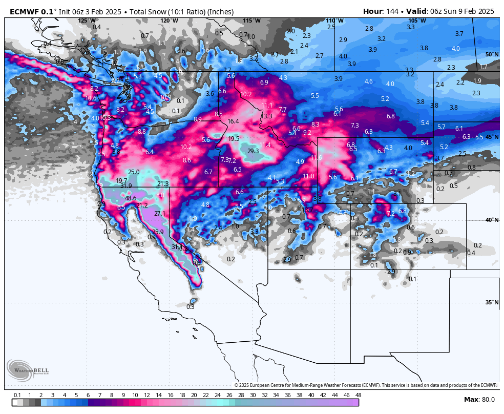
A series of active Pacific storms will bring rounds of significant mountain snowfall and periodic valley rain across the West this week, with the heaviest accumulations targeting the Sierra Nevada. Several waves will deliver fresh powder across the Northern Rockies, the Pacific Northwest, Utah’s Wasatch, and Colorado’s central and northern mountains through the weekend. Conditions will be unusually warm to start the week across many areas, then gradually trend colder around midweek. Expect snow levels to fluctuate, sometimes rising high enough for rain in lower valleys. Gusty winds will accompany each system, occasionally causing blowing snow and reduced visibility in exposed terrain. A few quieter interludes separate the main storm events. Looking into the weekend and early next week, unsettled weather remains a good bet for higher elevations, though confidence on storm track and intensity declines further out.
We labeled this an epic alert due to the huge totals across the west, primarily at upper elevations. Keep in mind that low to mid-elevations will be warm and wet with very dense snow.
NOTE: Please support Powderchasers with a donation, Merchandise purchase such as a hat or stickers, or sign up for our custom Concierge Powder Forecast Package, where we provide 1:1 phone and email support to get you to the deepest locations possible.
California

A prolonged series of storms will impact the California mountains starting today and continuing through late week. A warm, moist flow will allow snow levels to hover around 6000-7000 feet early on, with rain in lower foothills and valleys. The most robust surge arrives tonight into Tuesday, delivering intense snowfall above around 7000 feet, while rain spreads across middle elevations.
Midweek, another storm wave continues periods of heavier snow in the Sierra. Snow levels may briefly fluctuate, but eventually dip slightly by Thursday. Gusty southwest winds could create blowing snow in exposed areas, especially along ridges and passes. Travel over the higher passes will be challenging, with accumulations reaching several feet by late Thursday.
A final push late in the workweek looks to reinforce snowfall in the central and northern Sierra. By Friday, snow levels should remain high enough for rain below 6000-6500 feet, but heavy snowfall persists for the higher peaks. Periodic breaks in precipitation are possible, but total storm accumulations through Friday night will be substantial. Looking into the weekend, lighter snows linger off and on before conditions gradually diminish.
Medium-range outlook: Colder air could seep in briefly toward the weekend, but an overall moist pattern may continue, favoring additional light to moderate snowfall across the Sierra into the start of next week.
7-Day Resort Forecast Totals
- Sugar Bowl – 35–60” Mon Night (02/03)–Fri Night (02/07)
- Kirkwood – 33–57” Mon Night (02/03)–Fri Night (02/07)
- Palisades Tahoe – 32–55” Mon Night (02/03)–Fri Night (02/07)
- Mammoth – 30–51” Tue (02/04)–Fri Night (02/07)
- Northstar – 20–37” Mon Night (02/03)–Fri Night (02/07)
- Mt Rose – 15–28” Mon Night (02/03)–Fri Night (02/07)
- Heavenly – 14–25” Mon Night (02/03)–Fri Night (02/07)
Northern Rockies

Areas of Idaho, western Montana, and northwest Wyoming will see repeated surges of moisture arriving through mid to late week. Snow levels remain near or just above many valley floors today, especially in Idaho, leading to occasional periods of wet snow or mixed precipitation across some lower valleys. The biggest accumulations focus on favored mountain ranges, where moderate to heavy snowfall persists.
Early to mid-week, a mild southwest flow will keep precipitation going in the mountains, with additional bouts of snow through Wednesday. Some storms will bring short-lived, intense snowfall rates. Higher peaks could see substantial totals by Wednesday morning, especially across central Idaho’s higher terrain and the Tetons in western Wyoming. Snow levels occasionally creep upward during mild surges, turning lower valleys to rain, though quick dips at night may allow wet snow to accumulate.
Late-week, a reinforcing trough may swing in from the northwest, extending snowfall into Friday or Saturday in the Idaho and Montana mountains. Snow levels eventually lower, but cooler air won’t drastically drop into all valleys, so some spots could remain near the rain/snow line. Gusty winds over ridges will accompany these waves, creating patchy blowing snow above treeline.
Medium-range outlook: General unsettled conditions may persist into the weekend, though intensity wanes. Another system could arrive early next week, potentially keeping light snow showers going along the higher peaks.
7-Day Resort Forecast Totals
- Brundage – 25–43” Mon (02/03)–Sun Night (02/09)
- Sun Valley – 19–32” Mon (02/03)–Fri Night (02/07)
- Grand Targhee – 13–26” total (1–3” Mon (02/03) + 2–5” Wed (02/05)–Wed Night (02/05) + 10–18” Thu Night (02/06)–Sat Night (02/08))
- Jackson Hole – 14–25” total (1–3” Mon (02/03) + 13–22” Wed (02/05)–Sun Night (02/09))
- Bogus Basin – 13–23” Mon (02/03)–Fri Night (02/07)
- Big Sky – 8–18” total (1–3” Mon (02/03) + 3–7” Tue (02/04)–Wed Night (02/05) + 4–7” Thu Night (02/06)–Fri Night (02/07) + 0–1” Sat Night (02/08))
- Bridger Bowl – 6–14” total (2–4” Mon (02/03)–Mon Night (02/03) + 2–5” Tue Night (02/04)–Wed Night (02/05) + 2–5” Thu Night (02/06)–Fri Night (02/07))
- Schweitzer – 4–11” total (0–2” Mon (02/03) + 2–4” Tue (02/04)–Wed Night (02/05) + 0–1” Fri (02/07) + 2–4” Sat (02/08)–Sun Night (02/09))
- Whitefish Mountain – 3–9” total (0–1” Mon (02/03) + 2–5” Tue (02/04)–Wed Night (02/05) + 0–1” Fri (02/07) + 1–2” Sun (02/09)–Sun Night (02/09))
Pacific Northwest

Periods of cold, showery weather will continue into midweek, favoring moderate snowfall in the Cascades with brief breaks for inland valleys. Snow levels remain low enough for widespread snow in the mountains. Occasional bursts of heavier showers are possible, especially early in the week for the north Cascades, though totals are mostly moderate so far.
A few weaker disturbances continue through midweek, keeping off-and-on mountain snow showers in Washington and Oregon, with gusty ridge-top winds. Snow levels may stay around 1500-3000 feet for periods, leading to hit-or-miss accumulation in passes. Any thunder or graupel showers look isolated. Heavier accumulations focus on the southern Washington Cascades and northern Oregon Cascades when deeper moisture overlaps with cooler air.
Late in the week, a fresh push of moisture approaches from the northwest. This wave might bring a new batch of moderate snowfall for parts of the Washington and north Oregon Cascades Thursday night into the weekend. Snow levels gradually rise in some spots, so lower elevations could see mixed precipitation, but upper ski areas still receive snow. Winds remain somewhat elevated, affecting ridges and exposed slopes.
Extended outlook: A slightly drier pattern may take hold by Sunday or Monday, though scattered snow showers might linger in the Cascades. Temperatures should remain on the cooler side, with additional troughs possibly arriving next week.
7-Day Resort Forecast Totals
- Timberline – 16–28” total (0–1” Mon (02/03) + 16–27” Tue Night (02/04)–Sun Night (02/09))
- Mt Bachelor – 12–22” total (1–3” Mon (02/03)–Mon Night (02/03) + 11–19” Wed (02/05)–Sat Night (02/08))
- Summit at Snoqualmie – 7–15” total (1–3” Tue Night (02/04)–Wed Night (02/05) + 6–12” Thu Night (02/06)–Mon Night (02/10))
- Crystal Mountain – 6–13” total (4–8” Mon (02/03)–Thu Night (02/06) + 2–4” Fri Night (02/07)–Sat Night (02/08) + 0–1” Sun Night (02/09))
- Stevens Pass – 4–9” total (1–3” Tue (02/04)–Wed Night (02/05) + 3–6” Sat (02/08)–Mon Night (02/10))
- Mt Baker – 2–8” total (0–2” Mon (02/03) + 0–2” Tue Night (02/04)–Wed (02/05) + 2–4” Sat (02/08)–Sun Night (02/09))
Utah

High pressure and southwesterly flow will keep temperatures very mild into midweek, with only spotty snow across the highest peaks early on. Inversions are generally broken, allowing warm air into many valleys. Wind gusts may pick up along ridges, but minimal snow is expected through Tuesday.
By Wednesday, a weak system starts to bring lighter snow mainly to northern Utah’s mountains. Snow levels hover near 6000-7000 feet. Although accumulations remain modest, brief bursts of snow could occur in the Cottonwoods and other high terrain. Winds pick up from the southwest over ridges.
Another wave arrives Thursday night into Saturday, increasing the chance for heavier snow in the northern Wasatch and possibly the central mountains. Snow totals appear more notable for the Upper Cottonwoods, while valleys may see rain or a mix initially. Gusty winds could create occasionally difficult conditions at upper elevations, especially if heavier snow bands develop Friday. By the weekend, snow showers may taper but linger in favored west- or northwest-facing slopes.
Extended outlook: Next week may see additional weak disturbances crossing the region, though details are uncertain. Temperatures likely trend slightly cooler, suggesting more wintery conditions persist in the mountains.
7-Day Resort Forecast Totals
- Alta/Snowbird – 10–19” total (2–5” Wed (02/05)–Wed Night (02/05) + 8–14” Thu Night (02/06)–Sat Night (02/08))
- Powder Mountain – 10–19” total (3–6” Wed (02/05)–Wed Night (02/05) + 7–13” Thu Night (02/06)–Sat Night (02/08))
- Solitude/Brighton – 10–19” total (2–4” Wed (02/05)–Wed Night (02/05) + 8–15” Thu Night (02/06)–Sat Night (02/08))
- Park City/Deer Valley – 8–16” total (1–3” Wed (02/05)–Wed Night (02/05) + 7–13” Fri (02/07)–Sat Night (02/08))
- Eagle Point – 2–7” total (2–5” Fri (02/07)–Fri Night (02/07) + 0–2” Sat Night (02/08))
Colorado

Colorado remains under mainly dry and unseasonably warm southwesterly flow early this week, with minimal new snow until mid to late week. Very warm daytime temperatures will dominate Monday through Wednesday across the Front Range foothills and central mountains. However, scattered light snow showers may brush the northern mountains at times.
By Thursday night and Friday, a wave drops down from the northwest, bringing chances for mountain snowfall. Totals appear modest but could be enough for fresh powder across the central and northern mountains. Gusty winds along ridgetops are likely, though the deeper moisture is less certain. Higher bases near 9000 feet may see snow, with lower valleys possibly staying mostly dry or seeing only light accumulations.
For the weekend, scattered snow showers remain possible in the central and northern mountains, especially Friday night into Saturday. Amounts vary widely depending on storm track, but current indications suggest moderate accumulations in favored areas along and north of I-70. High-elevation westerly winds could periodically reduce visibility in blowing snow. Southerly mountains see minimal impacts.
Extended outlook: Temperatures likely trend near or slightly below normal by Sunday into early next week, with potential for another weak system bringing light snow to some mountain areas.
7-Day Resort Forecast Totals
- Steamboat – 6–13” total (1–3” Wed (02/05)–Wed Night (02/05) + 0–1” Thu Night (02/06) + 5–9” Fri Night (02/07)–Sat Night (02/08))
- Crested Butte – 4–9” total (1–2” Wed (02/05)–Wed Night (02/05) + 3–7” Fri (02/07)–Sat Night (02/08))
- Winter Park – 3–7” total (0–1” Wed Night (02/05) + 3–6” Fri Night (02/07)–Sat Night (02/08))
- Snowmass – 3–6” Fri (02/07)–Sat Night (02/08)
- Vail/Beaver Creek – 2–5” Fri Night (02/07)–Sat Night (02/08)
- Copper Mountain/Breckenridge – 1–4” Fri Night (02/07)–Sat Night (02/08)
- Wolf Creek – 0–3” total (0–1” Fri Night (02/07) + 0–1” Sat Night (02/08) + 0–1” Mon Night (02/10))
- Winter Park – (already listed above)
- Telluride – 0–1” Sat Night (02/08)
- Monarch – 0–1” Sat Night (02/08)
NOTE: Please support Powderchasers with a donation, Merchandise purchase such as a hat or stickers, or sign up for our custom Concierge Powder Forecast Package,where we provide 1:1 phone and email support to get you to the deepest locations possible.


