
Summary: Pow is falling over the Sierra with a final burst from the Atmospheric River, warm air, and very windy conditions. Cold air overspreads the Sierra late Thursday night and will pass over the Rockies Friday late AM or PM, depending on location. This storm will bring deep, surfy snow and light frosting on the tail end. NW winds might sneak out a few surprises in the Tetons or Wasatch late Friday.
This post is sponsored by Selkirk Powder Company, which offers ski touring trips and avalanche courses in a vast area of northern Idaho. This region has received over 15 inches of cold smoke powder in the past five days. Please check out Selkirk Powder Company if you want to ride crowd-less powder in the pristine wilderness northwest of Sandpoint, Idaho near Priest Lake. They still have open slots. Mention Powderchasers for free swag.
Sierra:
This is an afternoon update on snowfall well underway in the Sierras. The models are still very bullish for 1-2 feet above 8500 feet and 4-8 inches below 7500 feet. This storm is warm with good base building dense powder. Temps will drop by Friday morning, but so will snowfall's intensity. It is possible that colder, drier, density snow coat the surface for Friday. If you like white surf, this will be a perfect storm. You might also get lucky if the cold air keeps snow showers going into Friday morning.
Red Flags: Strong winds and high snow levels initially.
Below: Very impressive upper elevation snow totals mainly above 8000 feet, favoring the western crest of Lake Tahoe (Eastern zones also look decent), with perhaps higher amounts falling just south of the Lake or towards Mammoth.

Below: Powerful sustained winds above 60 MPH are noted at 10K feet on this gif below. The map is from Thursday PM to Friday late AM. You can see the drop in wind speeds associated with the cold front Friday morning. There is good hope that some upper lifts will eventually spin on Friday. You can see the wind bars from the SW shifting to the W and NW (Lowering winds) Friday morning.

IDAHO
Quick update: Snow intensity will increase Friday night over Idaho, favoring areas north of Sun Valley (Stanley region). SV still looks decent for 4-8 inches for your early turns on Friday. Warming also occurs during daybreak, increasing the odds of upside-down snow (Denser on top of the colder). Temps flip back to colder by late AM. McCall area mountains should also grab 4-9 inches (Moisture seems a bit focused to the south or east of McCall).
Tetons:
The Tetons fire started just before daylight hours on Friday and went through early PM on Friday. Snow intensity seems highest from 10 AM to 4 PM on Friday. The models are bullish on 9-15 inches totals by 7 PM Friday. Snow will start dense Friday morning but turn colder by 2 PM (better quality). Red Flag: Initially warm, dense snow confined to mid or upper peaks for the higher totals Friday. Winds will be very strong from the SW, likely causing upper chair delays or closures at both JHMR and Targhee.
Caveat: NW flow over the Teton Range for a brief period Friday late PM might kick off some intense hard-to-forest snowfall favoring the Targhee side of the mountain ranges. Initially, on Friday, JHMR or Teton Pass are slightly favored.
Utah:
Models are a bit more unpredictable for Wasatch. Our best forecast, looking at multiple runs of many scenarios, is 4-7 inches from Park City to the Ogden area mountains. Cottonwoods are highlighted on some models with enhanced snowfall bands from Friday late PM to the evening (similar to the Tetons with NW flow). The Cottonwoods, or even areas north along I-80 (Parleys), could sneak out totals in the 9-14 inch range by later Friday night. Red Flags: It will be windy on Friday, which could cause some upper lift holds. Comes in very dense. Winds decrease after 2-3 PM on Friday. Timing: Storm ski late Friday and catch more snow for Saturday. FYI: every storm in the past 45 days for Utah has landed on a Friday or Saturday! Maybe I should add "Crowds" to the red flags above.
Colorado: Currently, the trend is for mountain ranges north of I-70 to pick up 4-9 inches. Steamboat could log more. Areas along I-70 might see less (3-7), and Grand County (WP) might get lucky on a few models. Snow will also fall south towards Aspen (3-8), with the southern end near Crested Butte (2-5).
Wildcards: Southern Montana near Big Sky is in the colder sector of the storm. With less moisture noted for these regions, even 1/4 inch of water can land 5-9 inches of blower. We need to watch southern MT, including Red Lodge (Not usually ideal with SW winds).
Below: You can see the warm air temporarily take control of the central Rockies before a strong cold front Friday PM. Areas in Montana stay cold. The colder air should reach Colorado at some point late Friday night. That warming on Friday could be some Funk initially. The northern areas of Idha, PNW, and Montana also stay colder initially, with better quality pow and lower totals (Never warms up).

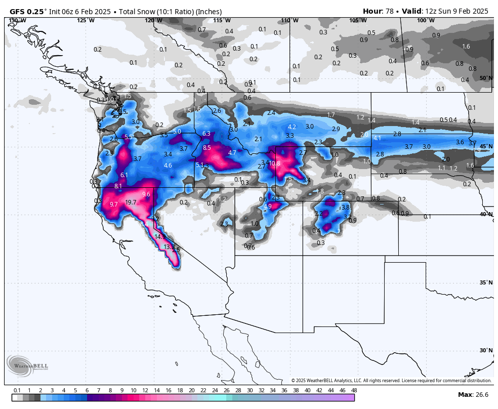
Below is the total snowfall for the west through late Saturday night. Central Oregon can also do well with this event (4-9), and the Washington Cascades are stuck in the frigid air (3-6). Seattle had snow today. Peak areas of snow are the areas mentioned above.

Please follow us on Instagram and FB @powderchasers
Forecaster: Powderchaser Steve @powderchasersteve on Insta.
NOTE: Please support Powderchasers with a donation, merchandise purchase(such as a hat or stickers), or sign up for our custom Concierge Powder Forecast Package, where we provide 1:1 phone & email support to get you to the deepest locations possible. When chasing snow, the Concierge gets you the very best intel. Sign up for our free email list so you never miss a powder day. We are also seeking new sponsors and ambassadors who want to submit photos and videos; please reach out on Instagram.


