
Powder Synopsis:
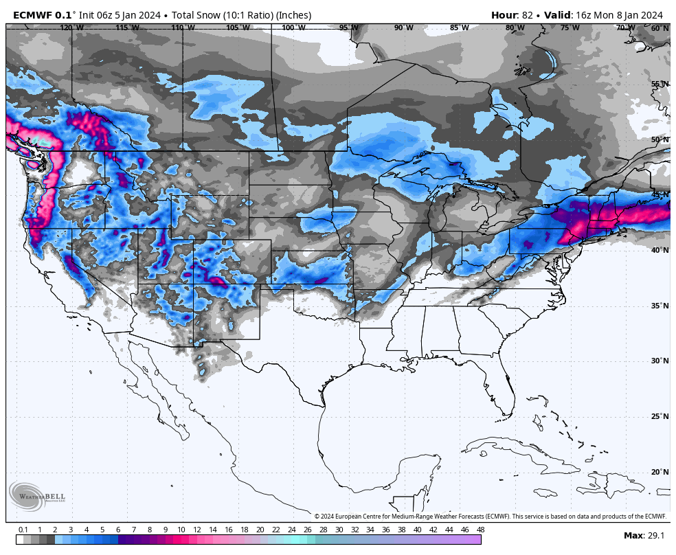
There are many options for riding deep snow this weekend. The West stays active with some deepness guaranteed for the PNW, western BC, with a bit less for the Sierra (Still respectable). The Rockies seem favored from northern Idaho to areas near Whitefish, Panhandle of Idaho and the Wasatch. The Tetons are on the cusp of a more moderate event with Colorado scoring teasers from Friday to Saturday when snow increasing over the 4 corners Sunday/Monday. New England scores Sunday (Southern resorts).

This post is sponsored by Tire Rack (Discount Tire) who is our preferred supplier of tires to chase powder. They have the most options for nearly every vehicle and have supported Powderchasers for over 5 years.
Below: Low pressure this weekend diving south into the 4 corners later this weekend with another storm approaching the PNW by Tuesday next week.

Snow is currently falling in the Wasatch Range albeit on the light side. The models throw some questions into storm skiing Friday with some suggesting a heavier event for areas just north of Interstate 80 or even the Northern Wasatch Range (Snowbasin or Powder). Others point to 5-10 inches for the Cottonwoods with 2-5 in the Park City ranges. This could boom or bust.
There are a few inches as of 8AM at many ski areas and it's currently snowing lightly. I suspect by noon you might see an additional 2-5 inches for many locations with an increase of intensity by 3 PM. Several inches might fall in those final hours of skiing. Bottom Line: Some upside to 5-10 inches (Cottonwoods or Northern Wasatch) by 4PM with a more reasonable guess of 3-8. The afternoon might see an increase in intensity before tapering Friday evening. Look for a surprise up north as a few models prefer the deepest totals near Snowbasin or Powder. Park City should be in the 2-5 range with higher amounts possible on the Canyons side.
Vegas Mountains Scored 16 inches Thursday!
On Thursday, I was in Las Vegas and drove 50 minutes to their local ski area, Lee Canyon Thursday afternoon. They scored 16 inches Wednesday/Thursday and opened the Blue Sky Chair for the first time of the season.
Most noteworthy Lee Canyon had severe damage from the Summer floods in August (Hurricane off the coast of CA). While I did not ride, the conditions looked very good on slopes that had previous snowmaking with locals telling me that they had knee deep powder off piste (Low tide). These pics below are an incredible turnaround.
Below: Lee Canyon Ski Area near Las Vegas with devastation last August (Rock and mud slide). This chair opened on Thursday with 16 inches of Powder for many locals that were there (Great job Lee Canyon). Can. you believe this comeback!


Above: Lee Canyon Ski are near Las Vegas January 4th opening Blue Sky Chair for its first time since the mud slides with 16 inches of powder.
PNW- Chase Friday afternoon
The next storm will bring significant snow to the southern BC resorts, especially Whistler Friday (Storm ski) and Saturday morning. Expect 5-7 Friday and 7-10 Friday night. With limited terrain open there will be a powder frenzy especially for the Peak Chair (Likely delayed but should open). Pros and cons on a chase here.
The Cascades will crank Friday night (Great timing) with 10-17 inches for Baker and 9-14 inches for Stevens Pass. Models show a bit less snow for Crystal (7-11). In Oregon, I am very bullish for widespread 9-15 inches from Bachelor to Timberline (Wide area). Quality will be very high, but unfortunately light density on top of a non existent base is not ideal.
Sierra- Chase Saturday midday.
The Sierra continues to show 2 solutions split between 10-20 or 9-15. Here is what I have confidence in.
* Heavy snowfall beginning Saturday midday and continuing into Saturday evening (9-14 for the ski areas).
* Very low snow levels bringing the first decent dump to the Reno Metro areas (2-6) and the Tahoe Basin (4-8).
* Areas closer to the Tahoe Basin are favored over the southern Sierra, with spots on the north side of the lake looking a bit deeper (Homewood, Northstar, Palisades, Sugar Bowl, Donner Pass). Mammoth will still do well but might report slightly lower numbers. There are no losers with this storm but models are a bit in disagreement on totals.
Below: Winds will be very strong over the Sierra Saturday morning (Sustained at 50 MPH at 10K) with gusts in the 80-100 range. Winds will decrease by late Saturday to Sunday as snow is falling.

Rockies/Idaho- Chases Friday/Sunday or Monday.
The trend is still for highlights and chases to exist from northern Idaho (Schweitzer-7-11) for Saturday extending into the northern Panhandle and areas near Whitefish (4-8).
The Tetons appear to be in the 5-10 inch range (1-3 Friday) peaking Saturday PM to Sunday AM (1st chair could be decent Sunday). The Wasatch will grab another 6-11 inches from late Saturday to early Sunday adding to what falls on Friday.
Colorado Challenging the forecast- Chase Sunday/Monday
Colorado grabs teasers Friday, especially near Steamboat or I-70 Friday (1-3) and see an increase of snow on Sunday mid morning. Colorado also presents the biggest challenge to my forecast with low pressure swinging into the 4 corners and pushing moisture north. The models disagree on totals but offer some trends.
*Colorado likely peaks Sunday morning to Sunday night (Taos in New Mexico peaks later Sunday to Monday)
*Western portions of I-70 likely see higher totals than resorts in Summit County due to S, SW, or North winds
*NE winds could provide a bit of an upside for the Front Range (Outside wildcard)
*San Juan Range likely to outperform the north with 7-14 inches by late Sunday
*Northern or central mountains looking generally in the 5-9 inch range (1 model shows more for Crested Butte)
*low confidence currently with so many factors and wind shifts and exactly where cells stall or develop.
* Snow showers continue into Monday (New Mexico focus is midday Sunday to Monday AM) with a few refreshes in Colorado possible. You might be able to chase to NM Monday?
Below: Total water from Friday (Today) through late Sunday for the west. You can see the highlights over the PNW, western BC (1-2 inches of water) with less noted for the Sierra (Still a respectable storm). Interior BC, especially southern areas look decent also. Northern Idaho, and Montana are in the .07 to 1 inch range. The Tetons are on the moderate end with the Wasatch and perhaps southern Colorado on the higher end. The American model not shown shows higher amounts for the 4 corners by later Sunday.

New England Chase
Significant snow will be falling over southern New England with some differences on the storm track. Plan to chase resorts from southern NH, southern VT, or western MA on Sunday (Storm skiing with some decent numbers when the lifts open).
Below: The American GFS keeps the low further south over Cape Cod and eastern MA with less snow for NH and VT. This solution is a bit of an outlier right now

Below: The European Model pushes further north with a more westerly and northerly push for southern Vermont or New Hampshire including the Boston Metro areas and missing the cape. This solution is inline with the short term NAM and National Blended models so confidence is bit more on this one (That's a good thing). Ride southern resorts.

The extended forecast offers very deep solutions.
Below: Models showing deep low pressure continuing from at least Tuesday January 9-13 with additional energy coming ashore in the PNW and dropping south over much of the west (It will be a deep week).

Help us out!
If you want to chase powder with Powderchasers sign up for the concierge package for the deepest resorts to chase to and 1:1 custom forecasting with our staff. Also, if you have read this far, please donate for the holidays to continue receiving these free forecasts. We appreciate the community support. You won't regret chasing with our custom forecasts.
Follow us on Instagram and Facebook @powderchasers
Powderchaser Steve @powderchasersteve - Instagram


