This post is sponsored by Tire Rack who can support all of your snow tire and wheel packages in one stop shopping. They can also ship at no additional charge to your local Discount Tire Store. Special offer: Any purchase over $500 that you can verify linked form Powderchasers will send you a swag bag from Powderchasers (Send us an email).
Forecast Details:
Finally after multiple days of strong SW winds, dense snow, and a moist atmospheric River in the PNW, we have a cold front that will bring a more typical mid winter colder pattern to the west. a potent cold front is currently making its' way into the PNW and northern Rockies. Snow quality will improve and winds will decrease.
In the past 3 days, we have chased from the Pacific Northwest to Utah and Wyoming. Stevens Pass was 18 inches deep on day #1, and Snowbird was a miss on Saturday (Winds, limited terrain, lower lifts) with Jackson Hole was a big score on Sunday (New terrain opened with deep snow).
The outlook for the next 48 hours looks very good for the central Cascades of Washington, the Panhandle of Idaho, the Tetons, Wasatch, and areas of north central Colorado (Southern Montana is a wildcard). Chase now! There is more snow for mid- and late-week.
Below: The dreamy cold front slams into the PNW Sunday and will quickly reach the Intermountain west by Sunday night/Monday. Goodbye to dense snow and "hello" to the blow. It's about time!

Below: The PNW per 2 models through Tuesday highlighting the central Cascades of Washington (Stevens and Snoqualmie Pass with the pinks in WA) and decent double digits for most of the Oregon Cascades. The influence of this storm will be from Stevens Pass south into Oregon. Most of the snow will fall Sunday night into Monday. Quality will be very high. The early bird brings the snorkel. Ride Monday!
Winds will shift to the West, which cranks out high odds of Puget Sound Convergence zones that favor the central Cascades but can also do well south towards Crystal (GFS on the left shows higher totals south, whereas the European on the right shows the central Cascades as heavily favored). Chase on Monday morning to any resorts favoring central Washington or south through most of Oregon. Further north, we will see less snow.

Below: Snow is filling in from the PNW Sunday, racing over the Idaho Panhandle and skimming northern areas near Canada by Monday morning. This storm's path will also initially impact northern Montana (Whitefish), followed by some wildcard winners towards Bridger and Big Sky (5-10). High confidence exists for 12-18 inches for the Tetons and perhaps the Wasatch Range. 
Some expected totals by Monday morning.
Stevens Pass: 12-17 inches
Crystal: 7-9
Baker: 2-5
Whistler: 2-5
Mt Hood: 12-16
Bachelor: 11-16
Whitefish: 8-11 inches
Brundage: 9-12 inches
Big Sky: 7-11 inches
Jackson Hole: 11-16 inches
Grand Targhee: 12-20 inches
Schweitzer: 6-10 inches
Selkirk Powder: 6-10 inches
Alta: 9-16 inches
Park City: 4-9 inches
Beaver: 7-9 inches
The models still disagree (GFS shown above), with the European a bit more pessimistic about Utah's high-end numbers. However, decent numbers are also seen in the areas east of the Wasatch in the Uinta Range.
Below: Colorado grabs decent totals from late Sunday night through late Monday, with some extra dipping for Tuesday morning. While the GFS and European models show 4-8 inches (Not shown), the short-term NAM below is slightly bullish for Colorado for 7-12 inches in a few isolated spots. The HRR runs less bullish for the western corridor and highlights the Continental Divide (Loveland, AB, WP, Eldora, Breckenridge) with a bit less further west. Bottom Line Colorado: Generally 4-8 inches for all mountains along and slightly south of I-70. Marginally higher totals are possible near Steamboat (NW winds) and areas south towards Winter Park, Berthoud Pass, and into eastern Summit County.

Below: The strong SW winds over much of the west will finally ease with the cold front passage on Sunday night as the direction switches to the NW. You can see the red gusty SW winds Sunday afternoon decreasing as the wind bars veer NW.
FINALLY!

Midweek storm (Starts late Tuesday in the PNW).
Below: 24-hour snow totals from Wednesday, January 1st through Friday, January 3rd. The path of this system begins on Tuesday in the PNW and drags over the Rockies, aiming at Idaho, Montana, and Wyoming with leftovers wrung out over Colorado (Weakens as it moves west to east).

Below: A Midweek storm is approaching the Rockies from the PNW by Tuesday, January 31st.

Later next week, a more potent storm will likely affect the Pacific Northwest and broader areas of the Rockies. This might cut off somewhere in the four corners and spread higher totals a bit further south than the current systems. Southern Montana finally looks deep with this system. (It's too early to speculate on details.). Right now, it seems like a decent storm.
Map: Friday, January 4 to Sunday, January 5th.

Below: The new system advances into the PNW late next week and overspreads a broader area of the Rockies (January 3-5).

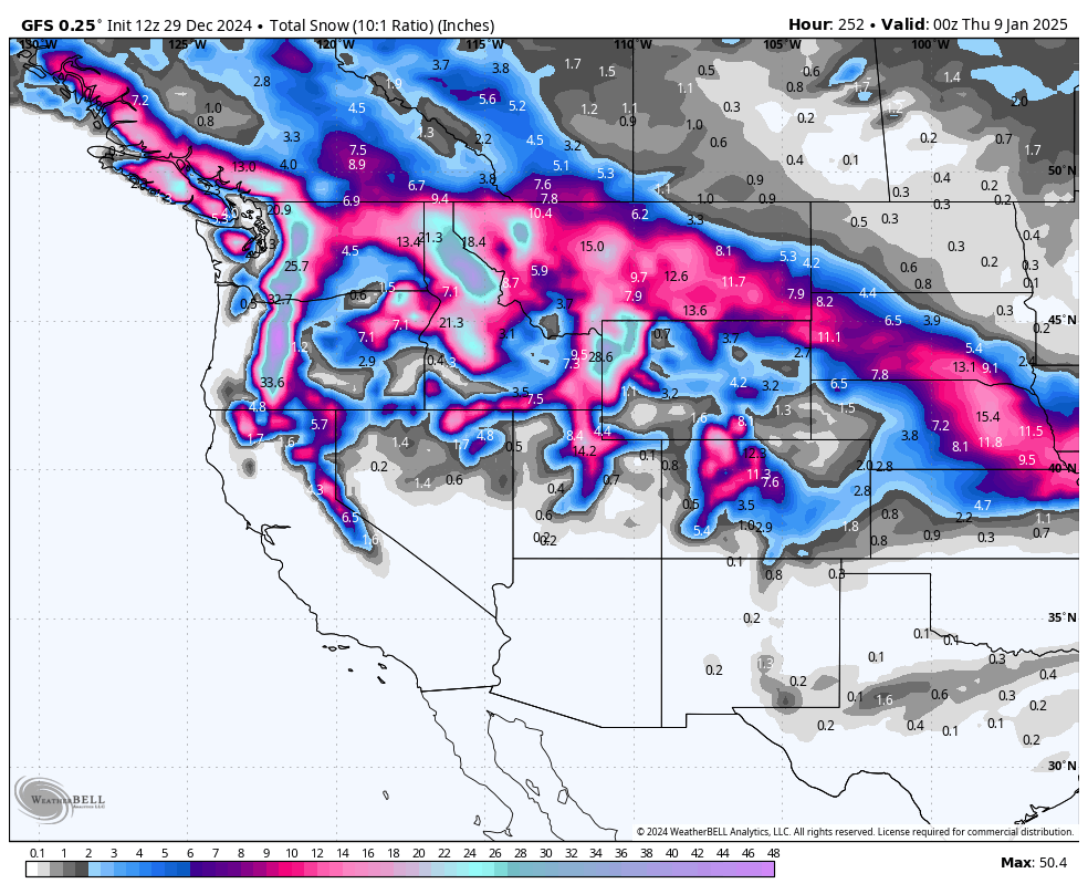
Looking into January 7-12, some scattered systems appear to be impacting Canada and the northern Rockies. However, nothing stands out currently to get excited about.
Please follow our instagram and FB pages for updates @powderchasers
Forecaster:
Powderchaser Steve @powderchasersteve on instagram


