Happy New year everyone! It has been a very active week with some big snow totals coming in from the Tetons, and Wasatch (20-40 inches) in the past 7 days. We migrated to a colder pattern as we indicated in the last forecast with very cold temperatures over the west.
Below: Mid Cirque opened for the 1st time all season at Snowbird on Tuesday (140 inches YTD snow) Photo: @powderchasersteve via instagram

Below: Skier: @Jstron_skis hiking up towards the backcountry near Cody Bowl in Jackson Wyoming. Photo: @jmosends

The next 24 hours from Wednesday to Thursday rings in a New Year of more powder expected primarily from late Wednesday to early Thursday. The favored locations for double digits will be in the Tetons (JHMR is favored with West flow), Wasatch Range of Utah (Many locations stand good odds), and northern Colorado from Steamboat, Winter Park, and extending south with slightly lower totals near I-70. The models show some differences.
Below: 2 short term model solutions with the NAM 12 on the left showing over 1/2 of liquid over many areas highlighted. The HRR short term model on the right is more bullish with over an inch of liquid (yellows) showing up in the Cottonwoods, UT/Wyoming border, and near the Tetons (Slightly east of Jackson). This would result in higher snow totals.
You can see the differences below in total liquid with the HRR more bullish (Not uncommon).

Snow totals averaged out based on temps and these models through Thursday morning (January 2).
Powder Mountain: 5-10 inches
Beaver Mountain: 5-12 inches
Park City: 5-10 inches
Snowbird: 6-14 inches
Jackson Hole: 6-11 inches
Steamboat: 7-14 inches
Winter Park: 8-10 inches
Vail: 4-7 inches
Breckenridge: 5-9 inches
Aspen: 2-5 inches
You can see the differences below in total liquid with the HRR more bullish (Not uncommon).
Below: Temperatures are warming in the Rockies with this system as noted below by early Thursday morning (-6C at 10K feet). Snow density will be light initially with medium to medium dense noted at lower elevations (upside down). Colder air is still noted over the Tetons. This storm should provide good cushion from the skied out terrain over the past few days.

Below: The Sierra grabs a moderate storm with good overnight timing from Friday evening to Saturday morning. This shows an influence of higher totals on the north side of Lake Tahoe with less further south.

Later this week while snow spread south over the Sierra, some decent totals are possible for the Cascades.
Below: Friday to Sunday- Snow totals increase over the PNW and Sierra (Late week) and trickle east over the Rockies. We see decent odds of heavier snow for the Cascades, Northern Idaho panhandle extending into Selkirk Powder and Schweitzer (Northern Idaho) with less snow into southern BC. The Rockies will continue to build slowly (Not major 24 hour period, but steady chug of light or moderate snow).

Below: New England scores powder (Moderate totals being reported on New Years) with a continual fetch of moisture through Saturday. This could land up to 18 inches or more for northern Vermont by Saturday with Thursday being the biggest bump. Strong winds might be an issue with this storm. Chase from central to northern Vermont for the highest 3 day totals (Storm ski Wednesday/Thursday) and look for new terrain openings Friday/Saturday.

Extended: Continued unsettled into the weekend with pieces of energy moving east over the Rockies from the PNW.
24 hour snow totals on a moving map from Saturday (January 4) to Tuesday (January 7th). You can see the storm this weekend in the PNW, and northern Sierra then trickle east through the weekend. By early next week (End of loop is Tuesday) the low will migrate south into Texas and loop some moisture north into New Mexico (Finally). Date and Day are in the upper right corner of map (Snow is shown as previous 24 hours).

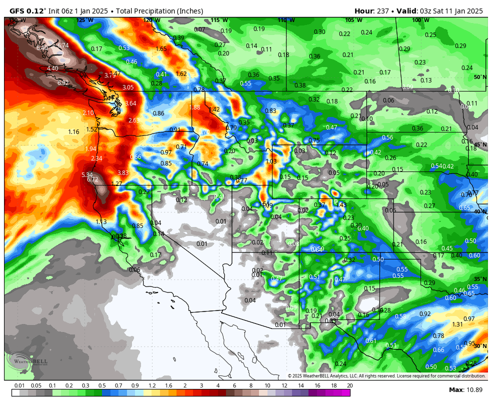
Below: Map is from Monday to Friday (Jan 10) next week. The low form the Rockies over the weekend moves far south over Mexico and stirs up some moisture over areas of New Mexico by Monday or Tuesday next week. High pressure takes grip on the PNW and Rockies by early to midweek.

Below: January 11-14- The ridge of high pressure still seems entrenched in the west. There is a signal that a low pressure system drops down from the Dakotas and influences the eastern flanks of the Rockies (Still too far out to predict with some hope of snow for areas of the eastern Divide from Montana to Colorado.

Follow us on Instagram and Facebook @powderchasers to never miss a powder day!
NOTE: Please support Powderchasers with a donation, Merchandise purchase such as a hat or stickers, or sign up for our custom Concierge Powder Forecast Package, where we provide 1:1 phone and email support to get you to the deepest locations possible. When chasing snow, the Concierge gets you the best intel. Make sure to sign up for our free email list so you never miss a powder day.
Avalanche Warning: Please be careful in the backcountry where 2 deaths have been reported in Utah in the past 3 days. Faceted snow combined with strong winds and dense snowfall initially this week has led to very sensitive snow conditions. "Know before you go" Equipment alone will not safe your life. Good decisions will.
Powderchaser Steve - Forecaster @powderchasersteve


