If you are reading this post, please consider a donation to support the Powderchasers Forecasts. Its a 5AM wake up call nearly every morning to attempt to provide you good information. Please use this link to help fill the powder bank for the season. Our forecasts are likely to continue into April with intermittent o
Summary:
Storm is still on track as of Saturday morning with the heaviest amounts due late Saturday through late Sunday Models are still diverging but becoming a bit more in synch. Many areas will score decent pow on this storm
Forecast:
I just flew back from Alaska on the Redeye to Denver!
Snow has been falling in the SE corner of Colorado and most of Eastern Utah as of Saturday morning. AZ Snowbowl reported 11 inches overnight. The Cottonwoods in Utah grabbed 7 inches! Heavy snow is falling over Vernal Utah and models show several feet for the Uinta ranges (NE corner of Utah). Lighter snow was noted on radar in the San Juan ranges of Colorado.
The storm is slowly tracking east and should reach the Front Range by 11 AM. Moderate snow will first be seen for the San Juan Range Saturday (Telluride could see 3-7). Light to moderate snow will be overspreading the Continental divide areas of the Front Range Saturday with the deepest amounts not coming until after the lifts close.
Latest trend is for snow to funnel up from the south (Low pressure is tracking over New Mexico) initially under SE winds. SE winds spinning up from the low appear to funnel heavy snow along the foothills as well as into areas of central Colorado (Monarch is a wildcard). Heavy snow may stream into Leadville, Ski Cooper, southern Summit County and west towards Eagle County by late Saturday night and Sunday, There appears to be a drier slot along I-70 near Dillan with higher amounts falling south or west (Low confidence on these fine details). Copper, Vail, Beaver Creek, and perhaps Aspen (Wildcard) could score 10-16 inches by late Sunday. Ski Cooper might see higher amounts.
Meanwhile, the Front Range will see the heaviest snow totals in the foothills just west of Boulder (3 feet). Ski areas near Nederland (Eldora) might report very high numbers on Sunday by early AM and more towards PM. Winter Park will also do well, albeit amounts might be a bit less. A Basin, Keystone and Breck are good bets (11-17) but not sure they will match up with resorts further north.
On Sunday the winds shift NW so watch for heavier snow bands to set up along I-70, and south towards Telluride.
Bottom Line: All resorts in Colorado should score decent powder from mid Saturday to late Sunday night, This storm has very high totals along the Front Range, with still decent snow totals for areas west of the Divide. Plan on riding late Saturday, early Sunday and again Monday (New terrain openings and some additional snow).
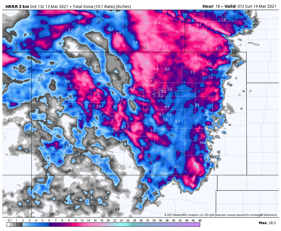
Below: Short term high resolution model showing snow is funneling up under SE flow through central Colorado into western sections of I-70 (10-18) The Front Range near Boulder or north of I-70 will see significant snow (20 plus) Telluride is the pink section in the left lower side of the map for good snowfall Saturday and Sunday (need to watch for Sunday and Monday as some snow will continue).

Below: The Euro continues to show a bit less snow for the western I-70 corridor but still very bullish for the Front Range, and north of I-70. Notice the bright colors near the Utah line (Left side) The region near Vernal, and the I-40 corridor through Utah will be very deep. This model is a bit more inline with the GFS now, but has a slower solution for the western most mountains, with snow continuing into Sunday night.

Powderchaser Steve


