
Hopefully, you enjoyed the last few days, when over 12 inches of high-quality powder fell in Utah on Thursday and 6-10 inches nabbed Colorado overnight into Friday. Temps have been well below normal in the past few weeks, with a warming trend on the horizon. We just finished an epic 10-day stretch of arctic powder and are about to be deluged with surf.
This post is sponsored by Alaska Backcountry Guides in Valdez, Alaska (Our long-term partner). ABG has only three slots still open for some epic heli-skiing. Conditions are deep in the heli zones (A great way to avoid the crowds and experience pristine AK Wilderness). Mention Powderchasers and receive a free Concierge program that is good for 2 years! 10-18 inches of high-quality snow is forecast for the next 7 days! There are only a limited number of seats available! Quality will be high.

A very wet Atmospheric River will bring 5-6 inches of water to the PNW, Western Canada.
Decent water totals will also be evident, albeit lighter for interior BC that trickles into northern Montana, Idaho and perhaps the Tetons next week.
As far as chasing powder, we would encourage you to stick to higher elevation resorts such as Whistler or grabbing slightly cooler temps in the interior of BC this weekend into next week.
Below: Winter Park Ski Area on Friday morning.

Below: Loveland Ski area grabbed 5-9 inches overnight Thursday for some fresh powder turns Friday.

Below: Total moisture from Friday to Tuesday, February 25. Significant water totals of 5-6 inches with snow levels in the Cascades skyrocketing to 5500-6,000 feet by the weekend (Rain at the bases and mid to upper slopes). Slightly cooler conditions prevail in Canada, where Whistler grabs 4500-foot snow levels and significant dense snow from mid to upper slopes. The summit of Whistler might see 12-25 inches.
The interior of BC is also a bit cooler, with snow levels in the 4-4500 range this weekend and 5-10 inches of dense snow through Monday towards the summits.

Below: Temperatures spike on Sunday. The map is at 4800 feet—notice 4C (39F) in the Cascades and near freezing to 1C (33F) in Canada. Temps will cool slightly early next week, but it continues to be unseasonably warm.

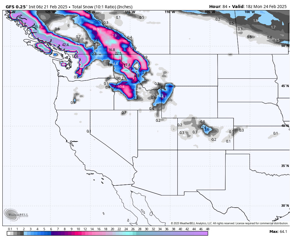
Below: Total snowfall through Monday morning is significant at the peaks of western Canada, the high summits of the northern Cascades (In some cases above the ski area terrain), and decent for interior BC (12-15) at upper elevations.
Decent surf snow will fall from Selkirk Powder, Schweitzer, to northern Montana at Whitefish (8-12) this weekend and next week. Some rain might be mixed with snow, depending on the elevation. The Tetons grab the wrung-out spongy leftovers from Sunday to Tuesday next week (3-8).

Looking out into the rest of next week, we enter high pressure in most areas until Friday or Saturday, perhaps.
Below: Tuesday, February 24 to Sunday, March 2nd. High pressure will dominate the west by the middle of next week as the low on this map pushes east of the Rockies. A fast-moving system is showing up on models near the end of next week, February 28th. This quick mover favors southern California before heading south over Arizona and into Mexico by the weekend. We must watch this for any moisture that could stream north of the low. Currently, it does not look impressive.

NOTE: Please support Powderchasers with a donation, merchandise purchase (such as a hat or stickers), or sign up for our custom Concierge Powder Forecast Package, where we provide 1:1 phone & email support to get you to the deepest locations possible. When chasing snow, the Concierge gets you the very best intel. Sign up for our free email list so you never miss a powder day. We are also seeking new sponsors and ambassadors who want to submit photos and videos; please reach out for more.
Powderchaser Steve - Instagram @Powderchasersteve


