
Current Radar: Moisture is pushing into the PNW on Wednesday morning. Photo: OpenSnow maps- Current Radar

Snow showers continue in Colorado, with Keystone looking decent from late Tuesday to Wednesday. These snow showers are ending on Wednesday morning.

This post is sponsored by Alaska Backcountry Guides in Valdez, Alaska (Our long-term partner). ABG has only three slots still open for some epic heli-skiing. Conditions are deep in the heli zones (A great way to avoid the crowds and experience pristine AK Wilderness). Mention Powderchasers and receive a free Concierge program that is good for 2 years!

Powder Alert Breakdown by Region.
Pacific Northwest:
A new storm is approaching the Cascases on Wednesday morning. This storm twists (Wind and temp changes) often, onset Wednesday by 4 AM and continuing into the evening. Winds from the south on Wednesday morning will initially favor Crystal Mountain, followed by winds from the Southwest (favors Baker). Lighter snow is noted over the Oregon Cascades. Winds shift W and NW Wednesday night (Favors the central Cascades near or north of I-90).
Warming occurs in the PNW, which will keep snow totals relatively light or moderate on Wednesday (Snow levels rise Wednesday late AM from 3,000 to 3500 or near 4,500 or higher in Oregon.
Below: A warm front on Wednesday morning in the PNW keeps the snow levels above 4,000 feet in Oregon, with colder temps from the interior of Washington keeping these regions colder (3,000 to 3500). Snow will initially be medium-density on Wednesday, followed by colder air at late PM (4800-foot temps in C). Stevens and the I-90 Corridor might stay colder initially Wednesday, with trapped cold air pushing east from the colder interior. You can see the fine line between warm and cold, impacting the passes on Wednesday morning.

Below: Late Wednesday night and into Thursday, temperatures will drop in the PNW, with the final surge of moisture, which is weaning and coming in with light density. We like storms that start warm and end cold.

Below: Look at the wind arrows from the South (Gusty) on Wednesday morning, quickly migrating to the west Wednesday evening and NW by Thursday (Decreasing). The westerly flow on Wednesday evening could bring some convergence zones with the colder air for the I-90 corridor and possibly Stevens Pass.

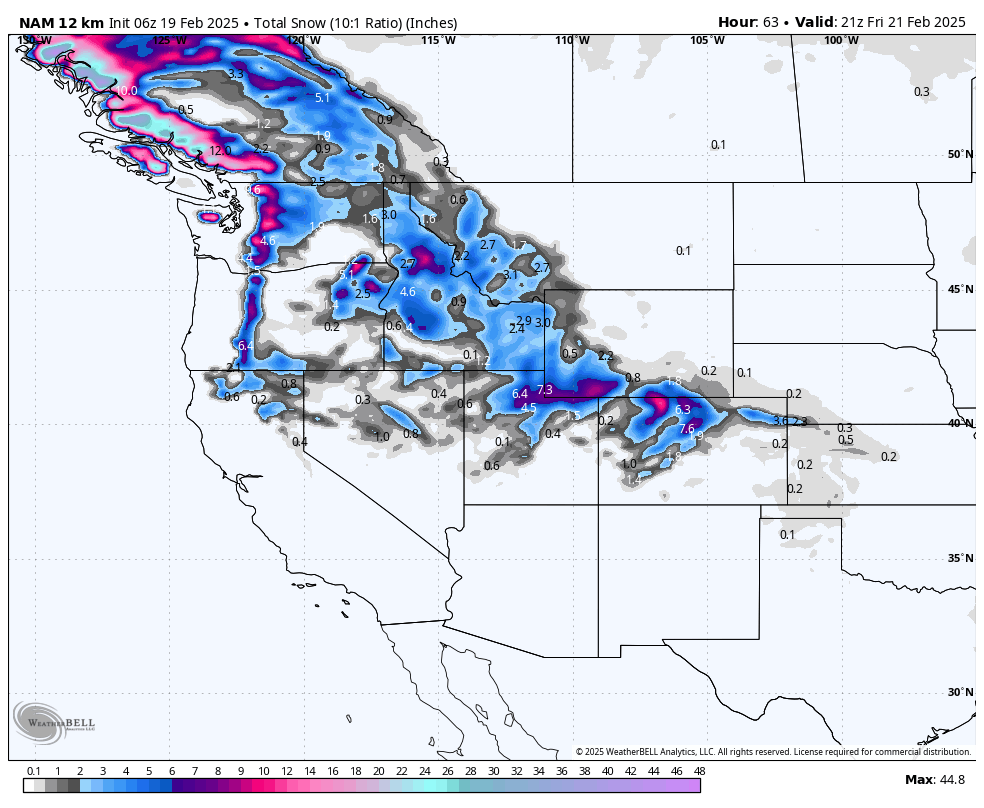
Below: Total snowfall through Thursday morning, favoring the Washington Cascades. With wind shifts from S, W, and NW, it's a tough call on who scores the highest totals. I would estimate 5-10 inches for the western Cascades, 2-6 on the interior (Mission Ridge), and some upside possible for the colder air Wednesday night where the I-90 corridor or Stevens could score higher totals (This map favors the I-90 corridor). Whistler also grabs some moderate mid or upper-mountain totals. Ride the last chair on Wednesday and the first chair on Thursday.

Idaho/Rockies
Below: Moisture from the PNW advances into Idaho, pushing south over the Wasatch (7-13) by Wednesday night and Thursday. The Tetons and southern Montana are on the northern end of the highest moisture with lighter totals (2-5). Colorado earns its turns from Thursday late AM through Friday morning (5-10). You could chase from Utah to Colorado with this storm.

Chases?
We are confident that the Wasatch Range will approach 7-14 inches, timing Wednesday night into Thursday midday. Some models push the higher totals north of I-80, so watch Powder and Snowbasin Wednesday night. Reasonable confidence that totals by first chair Thursday landing in the 4-9 inch range with 9-13 by 11 AM. NW flow on the backside could bring some upside to the Cottonwoods on Thursday.
Colorado gets into the action from midday Thursday to Friday. Models show general impacts along the I-70 corridor from Summit County west to Aspen and even south to the northern San Juan range (Telluride). Totals will land in the 5-10-inch range with some upside possible near Steamboat, Winter Park, or the Divide (Loveland, AB). The best guess is to chase along I-70 near the Divide or north to Steamboat—more on a later post—Chase late Thursday to early Friday in Colorado.
Below: American GFS shows 6-7 inches at Alta by 5 AM Thursday and up to 10 inches by 2 PM. This is reasonable. NW flow could bring a bit of upside (10-16).

Extended:
The trend is for a ridge to settle over the west later this week and well into the following. This ridge will force moisture north into Canada and eventually swoop south over the eastern areas of the US.
Below: Saturday night, February 22nd, to Thursday, February 27th, shows the high-pressure ridge over the west with any lows shunting north into Canada before dropping south over the Mid-Atlantic or New England. Scraps might fall into Idaho.

Below: 24-hour snowfall totals show decent odds of moisture impacting Canada later this weekend into early next week (Warming with generally 3500 or 4,000-foot snow levels). The interior and western BC could do well at upper elevations later this weekend. In the Rockies, I have low confidence in any significant storms through the end of next week.

NOTE: Please support Powderchasers with a donation, merchandise purchase (such as a hat or stickers), or sign up for our custom Concierge Powder Forecast Package, where we provide 1:1 phone & email support to get you to the deepest locations possible. When chasing snow, the Concierge gets you the very best intel. Sign up for our free email list so you never miss a powder day. We are also seeking new sponsors and ambassadors who want to submit photos and videos; please reach out for more.
Powderchaser Steve - Instagram @Powderchasersteve


