
Snow is falling in the Tetons, and temperatures are near or above freezing at many base locations. 9 inches of surfy snow can be found Monday morning at Targhee and JHMR. A higher base altitude at Targhee might make a better chase to avoid the butter, likely below 7000 feet. The subsequent chase and this powder alert are for a significant storm that will impact the PNW Monday/Tuesday with up to 20 inches of snow for some ski areas. Temps will migrate from warm on Monday to colder on Tuesday (3,000 snow level).
PNW POWDER ALERT
Over the past few days, the PNW has been barraged with 2-4 inches of liquid precipitation below 6,000 feet. Snow levels dipped lower on Sunday night (4,000), with telemetry showing 1-4 inches at many ski areas in Washington.
Alpental: 4 inches
Baker: 3 inches
Crystal: 1 inch
The storm to chase will be coming Monday-Tuesday, with the most substantial precipitation rates noted for late Monday night to midday on Tuesday. Strong SW winds will crank high gusts over the central and southern Cascades of Washington Monday night and will likely impact snow quality. Winds shift to the west early Tuesday morning and eventually NW my mid-morning. These wind shifts should favor many ski areas in Washington.
Here are some expected snow totals for the next storm:
Whistler: 3-6 inches
Baker: 8-10 inches
Stevens Pass: 9-16 inches
Alpental: 9-16inches
Crystal Mountain: 12-19 inches
White Pass: 9-15 inches
Selkirk Powder: 8-11 inches
Timberline- Mt Hood: 5-11 inches
SPONSOR SHOUT OUT
This post is sponsored by Selkirk Powder, which offers ski touring trips and avalanche courses in northern Idaho. This region will receive powder in the next 3 days. Please check out Selkirk Powder if you want to ride crowd-less powder in the pristine wilderness northwest of Sandpoint, Idaho, near Priest Lake. They still have open slots. Mention Powderchasers for free swag!
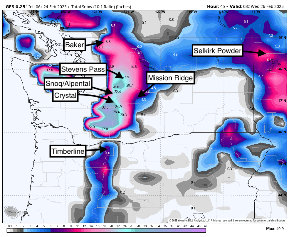
Below is the total snowfall in the Cascades and northern Idaho from Monday to Tuesday. Snow will be heaviest later Monday (Last chair) into Tuesday morning. Mountains in central Washington (-I-90 corridor north to Stevens Pass) and the southern Cascades near Mt Rainier, including Crystal and White Pass, seem favored. 12-18 inches possible for the central and south Cascades of WA, 5-12 near Mt Baker, and 5-10 further south in Oregon. Schweitzer could nab 5-9 inches. Some upside is also possible.

Below: Warm initially on Monday (4,500 feet or higher) with a cold front due Monday night into Tuesday (Snow levels 3000-3500).

Below: Winds late Monday night will be strong from the SW but decrease on Tuesday with a shift to the west (Convergence zones might be set up over the I-90 corridor or Stevens) before switching to the NW by midday.

Below: Snow totals through Tuesday favor the Cascades of Washington, including northern Idaho and the Panhandle. Some moderate snow is also possible in southern BC, closest to the Idaho border.

The Good: Plenty of moisture for isolated central and southern Washington areas. Temperatures are falling, and snow levels are near 3,000-3500. Strong winds, while usually a red flag, will smooth out the chunder from the recent rain and might initially put enough density down before winds decrease on Tuesday with better snow quality.
The Bad: Strong winds might create a dense day on Tuesday or some early morning lift holds.
Bottom Line: This is a good storm with much-needed snowfall. However, who will likely grab the highest totals is limited, likely in Washington and much less in Oregon and BC. Overnight totals from Monday to Tuesday will be double digits. Conditions might be variable due to winds.
Below: An active period might take hold in early March. The period from March 3rd (Next Monday) through March 5th looks to bring some snow back into the Sierra and central or southern Rockies (CA, UT, CO) with AZ/NM wildcards.

Below: March 1- March 5th. An initial weak system rapidly moves into the southern Sierra and four corners (March 1-2), followed by a more substantial system favoring the Sierra and central or southern Rockies from March 4-5. A third system in the Pacific is noted at the end of this loop (March 5).

If you have read this far, please support us below.
NOTE: Please support Powderchasers with a donation, merchandise purchase (such as a hat or stickers), or sign up for our custom Concierge Powder Forecast Package, where we provide 1:1 phone & email support to get you to the deepest locations possible. When chasing snow, the Concierge gets you the very best intel. Sign up for our free email list so you never miss a powder day. We are also seeking new sponsors and ambassadors who want to submit photos and videos; please reach out for more.
Forecaster: Powderchaser Steve @powderchasersteve via Instagram


