It's snowing in the high country of Colorado Thursday morning. Snow produced some intense bands with lightning strikes overnight producing a quick 7 inches for Wolf Creek and Telluride. SW flow is migrating to a more NW wind direction which will increase snowfall for the central and northern mountains late AM Thursday to about midnight.
Our forecast going into this storm was 4-8 inches overnight for the southern mountains with another 2-5 possible during the day Thursday. Confidence in much additional snow in the southern mountains is a tad lower on Thursday morning. Snow is falling over I-70 currently at upper elevations of many resorts. Vail Pass seems favored initially in this pattern (NW flow). By 1 PM today it's possible some ski areas along I-70 report 2-5 inches on the webcams (Stay alert). Model data focus a decent band of snow to set up just north of Georgetown extending up to Berthoud Pass, Winter Park, Rocky Mountain National Park, and perhaps Eldora early PM Thursday to midnight. It's possible that some Front Range resorts report 5-9 inches from noon Thursday to early Friday. Winds west of the Divide remain NW (Good for Vail Pass, and perhaps Breckenridge) while near the Divide they are N, NE. This makes for some variability in snow totals. Anyone is fair game in my opinion to be in the 5-9 inch range by Thursday evening. Bottom Line: Some decent bands of snow are likely to produce chaseable snow totals by Friday morning. Unfortunately, it's going to be split between AM and PM snow totals. Variability in where the heaviest bands set up (Likely to be the northern Front Range resorts) might produce both upside and downside surprises. Be prepared to chase for late Thursday or early Friday. Someone will score decent totals in the north/central mountains.
Below: Webcam at Telluride on Thursday morning (Showing 5-6 inches). The official report was higher.

The extended update brings a moderate to perhaps heavier system to the North Cascades by Saturday. Northern Interior Cascades see less. Canada once again will score heavy snowfall along the western BC mountains including Whistler late this week (9-15). Snow from the NW Cascades trickles through southern areas (WA and OR) with light to moderate amounts. The Sierra grabs the leftovers for Saturday morning (A moderate event). If Canada were open, I would be chasing right now.
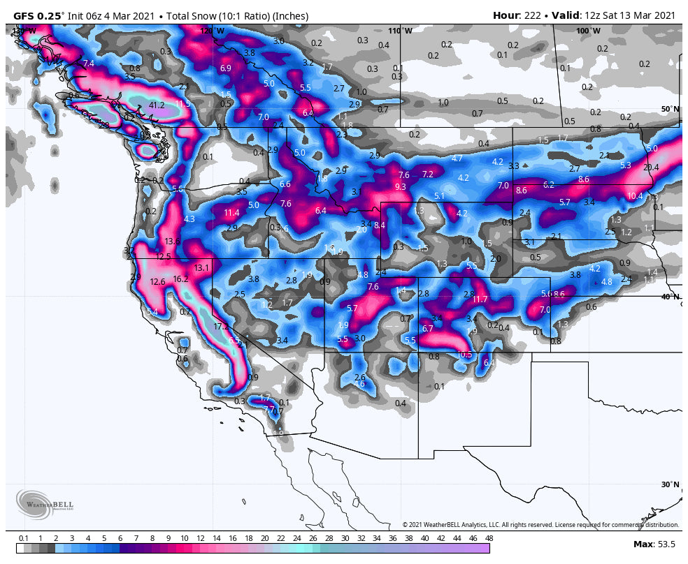
The long-range models are in good consensus of a long-duration snow event for the Sierra next week. Snow will also be falling to the north into Oregon albeit lighter. Several periods of snow in the Sierra next week will produce significant totals as the week rolls on. This system will head east and impact the Rockies. The highest amounts currently for the Rockies might favor areas of Montana that have not seen the bullseye in a while. Also, the northern Sawtooths of Idaho could benefit. Colorado and Utah will grab leftovers mid to late next week (Moderate amounts). There is a hint of a stronger system impacting Colorado by next weekend. Looking that far out poses a very low confidence forecast.
Below: Total snowfall for the west through next Saturday (Less reliability in looking this far out). There is high confidence in a stormy period next week, especially for California. Many spots in the Rockies will also see snowfall especially Tuesday into Wednesday. Late next week might produce a decent storm for Colorado.

If you are looking for a small group, Heli experience in some pristine mountains of Alaska there is only 1 seat left for the entire season from March 15-21 at Alaska Backcountry Guides. Mention Powderchasers for a free Concierge membership for next season. They are bringing Heli-Skiing to the next level for service and terrain.
Powderchaser Steve


