Overall Powder pattern: Warm air with rain/snow for mid elevations and rain at the bases of most of the Cascades this weekend will change to all snow in the later period. Wet snow is likely above 7,000 feet in the Rockies this weekend and some spots could be deep at the summits. Next week features a polar jet that pushes south over the Cascades, Sierra, and Rockies with deep powder.
Pow Forecast:
Wrapping up the past storm, I would say it performed very close to the last forecast with 20-plus inches in the southern San Juan mountains, and 5-10 further north in Colorado. Utah scored the 6-12 inch mark as forecasted with a bit of an upside for Park City (12-15) where a trough axis set up along I-80 on Wednesday night. Looking at webcams on Friday morning nearly every resort in Colorado scored some powder.
Below: @powderchasersteve via Instagram riding 12 inches plus In Little Cottonwood early Thursday morning. Park City slightly edged out these totals.

Below: Park was mid winter deep on Thursday morning. Photo @powderchasersteve via instagram. \"who's car is that\"?

Below: Steamboat did pretty well under SW flow pushing moisture up over I-70 initially and when the winds shifted to the NW scored additional amounts. The Snow telemetry near the resort has indicated 17 inches in some areas of the Flattops.

Below: Keystone near 6 inches. Many resorts near the I-70 corridor scored 5-10 inches.

The next few days ahead offer a mixed bag with an AR event bringing copious amounts of moisture to the PNW and northern Rockies. Cold temps initially Friday morning will warm late evening to Saturday morning bringing mainly rain to the Cascade Ranges below 6500 feet. The upper flanks of northern Montana and the Idaho Panhandle will see moderate or heavy snow at the summits with rain at the base. This will favor Glacier National Park (Just east of Whitefish) and the central regions of the Idaho Panhandle, with less snow in southern Montana (Big Sky, Bridger). Moisture slams into the Teton Range later Friday into late Saturday. The intensity of precipitation will drive snow levels down briefly to lower elevations but with the overall warm air most heavy snow will be confined to areas near or above mid-mountain at JHMR (9-14) and just above the bases at Targhee. Brief periods of wet snow will impact the Valleys albeit light. The winds are primarily W-SW so it's likely JHMR will be favored with this storm as well as the upper aspects of Teton Pass. Bottom Line: If it were mid-winter this storm has red flags primarily upside-down snow initially and some mixed precipitation or rain at times at lower elevations (Rain in the Cascades). This is a great base-building storm for upper elevations of the Rockies. Avalanche danger will be rising due to the moisture content of the snow that falls Friday/Saturday. Temps are cool behind the warm front and AR bringing snow to the lower elevations of the Cascades and Rockies later Saturday but snowfall intensity will be lighter.
Below: Snow liquid ratios at JHMR flip-flopping from 17:1 (17 inches per 1 inch of water) down to below 10:1 later Friday night (Glop) and lowering again late Saturday. (This can equal some dangerous conditions in the backcountry with the moisture content Friday night). Strong winds will make things a bit worse.

Below: Total moisture for the Tetons is upwards of an inch of water through midday Saturday.

Below: Cascade snow will be meager below mid or upper elevations until late Saturday when some light or moderate snow begins as temps cool. Next week will offer deeper dumps and snow levels as low as 500 feet! WOW.

Below: Northern Idaho is a wildcard with cold temps Friday, Warming Saturday and cooling Sunday. Selkirk Powder Guides could score decent snow totals at the summits with higher elevation benefits.

For the rest of the west, moisture will reach northern Utah late Friday night and continue with a warming trend Saturday. Snow levels will rise to 7,000 feet or higher with very dense snow even at the summits. Currently, models show higher moisture for the northern Wasatch Range and Logan area (Beaver Mountain). It's possible that the summits of the northern Wasatch (Ogden area or north) and southern Idaho ski areas grab 12 plus inches with just 1-3 inches at lower elevations. Moderate rain/snow are expected along I-80 or south. Temps cool Saturday night into Sunday as moisture drops a bit further south so it's also possible Sunday ends up being a moderate event for the Cottonwoods (Mid or upper elevations) with a bit better density (Avalanche Danger will be increasing).
Colorado grabs the leftovers favoring areas north of I-70 near Rabbit Ears pass this weekend. Some snow will edge into the I-70 corridor by late Saturday but amounts may not be impressive.
Below: Total moisture through early Sunday morning for the Rockies highlighting the Tetons (1.95 inches), north-central Wasatch Range, and perhaps northern Colorado (Primarily north of I-70).

Extended Deep Pow
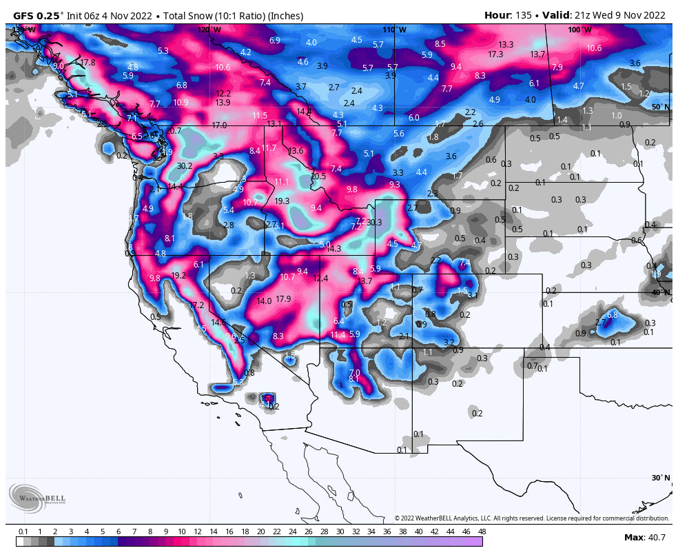
The headlines will be starting late this weekend into mid-next week when a polar jet races down frigid air kicking off some significant snow to the Cascades, Sierra, and Rockies.
Below: Strong cold front dropping snow levels in the Cascades to nearly 500 feet (Incredible for early November) and racing south into the Sierra and Rockies. Snow will be falling in many western locations. This might bring several feet of powder to many locations, especially Monday-Thursday.

Below: 3-day snow totals through late Tuesday night (next week) are impressive over most areas of the west especially the Cascades, Sierra, sothern Idaho (Sun Valley), Tetons, Wasatch, northern Arizona, and southern Montana. Colorado is in the \"let's see what happens\" stage that far out, but the amounts are expected to be a bit lighter.

Announcement: Shredfest is this weekend in Salt Lake City. Powderchasers will be there (meet the team) with a dog competition (Bring your pups) and prices.This event sponsors numerous bands and an incredible rail jam. If you want deep powder join our concierge program that puts our forecasters in touch with you directly on where and when to chase deep snow. You will end up in the deepest spots. It also helps fund our forecasts. Or simply make a donation here.
Help us out by becoming a sponsor! We are always looking for new partners. Also, if you have snow-weather ski experience contact us about future internship or positions as a forecaster. Support our current sponsors!
Be careful this weekend if you are in the backcountry, as these storms will contain lots of moisture as opposed to some of the others we have seen in the past few days.
Powderchaser Steve Instagram
Get your snow tires on!
Powderchaser Steve


