Good morning powder lovers! This is Powderchaser Steve with your Sunday morning flakes report. Ullr the snow god has returned to the west with perhaps our earliest-ever \Snorkel Alert\". The next storm system will move slowly over the Cascades on Sunday dropping south over the Sierra for Monday and eventually pushing east setting up over the NV/CA border and pushing ample moisture north and east with strong S, SW winds. The Cascades of Washington and Oregon will do well Sunday (9-15) with the Sierra getting slammed Monday/Tuesday (3-4 feet).
Powderchasers has very high confidence of 3-4 feet for the Sierra Crest with perhaps higher amounts in some isolated locations.
Roads will be impassable in some cases and if you don't have your snow tires on yet, do it now! That moisture moves east and gets pushed north into Idaho, Wyoming, Montana, Utah, and eventually Colorado later next week. Ski resorts will likely have early openings after this event. This has been a great start for many ski areas in the west and it's about to get a lot better.
Announcement: Powderchasers and our forecast staff is supported by our readership, so if you have not donated, please do so here or join our powder concierge program where we provide 1:1 trip planning for powder, last-minute custom forecasts and steer you to the deep. Support our sponsors listed on the webpage and be sure to follow our Instagram and Facebook page @powderchasers
You can also sign up for our powder alerts at www.powderchasers.com
Forecast:
Models for Sunday and early Monday show 6-10 inches for the Washington Cascades. Winds are SW favoring Mt Baker (7 inches as of 6 AM Sunday), and switch to the south and even SE at times. That will increase snow totals for the northern interior Cascades north of Wenatchee to the Canadian border and also favor the southern Cascades of Washington where moisture can funnel into areas near or above the Oregon border (White Pass). Crystal can sometimes sneak up some deep surprises on S, SE flow but it's a wildcard at this point (5-10). Oregon resorts will see slightly higher amounts, especially near the WA border and extending south to Mt Hood (12-18). Bachelor is also going to score freshies but the amounts might be a bit less.
For the Sierra, the celebration begins on Monday morning when snow will be falling from north to south during the day. By late Tuesday 2-4 feet will be in its wake above 7,000 feet and 1-2 feet at lower elevations. The lake will see a decent event with snow levels In the 5,000 range. There is a slight warm-up Tuesday Morning before very cold temps driving snow levels lower occur into Wednesday (Moisture will be east of the area as the coldest air arrives).
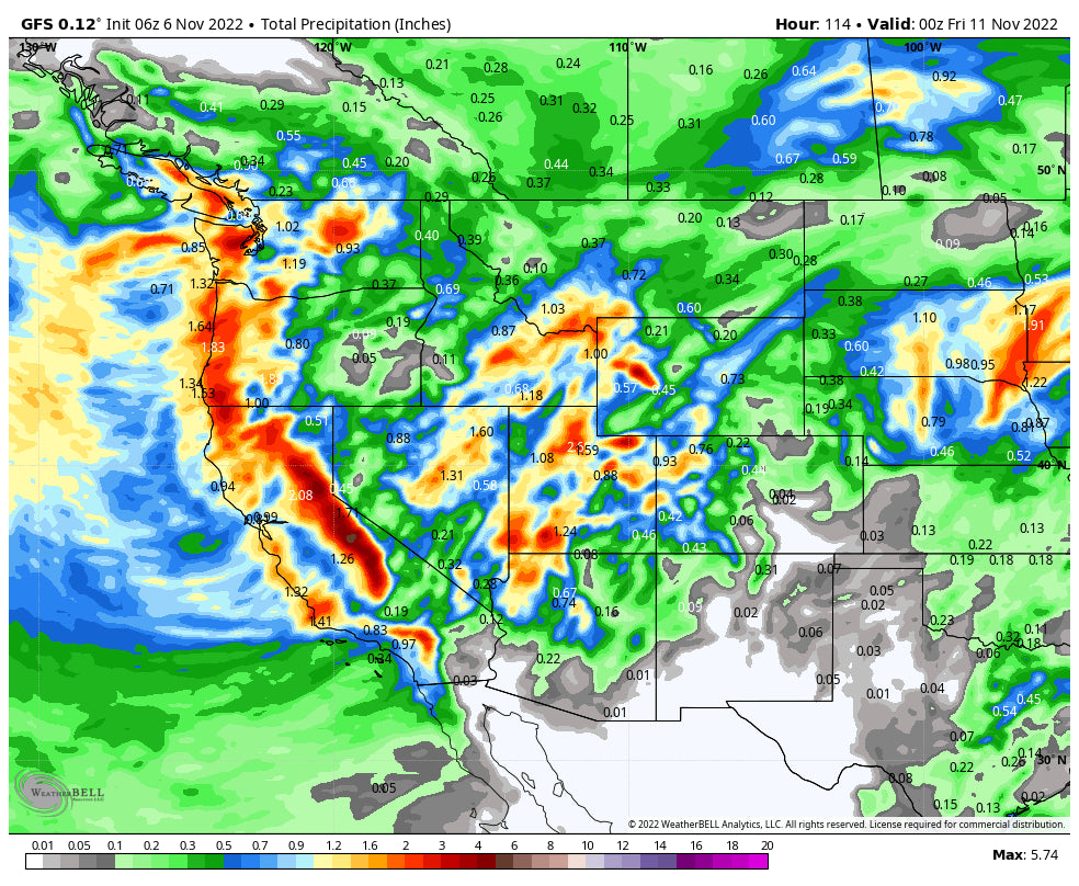
Below: Total moisture for the Sierra Crest showing nearly 3.6 inches and in some cases 4-5 inches noted closer to Mammoth These totals will = 20-40 inches of snow and in some cases at the summits even higher amounts are possible.

Below: The totals issued by NWS are very impressive matching the same data we are seeing. WOO HOO

Rockies:
From the Sierra, this storm sets up over the Nevada-California border and starts to impact Idaho as early as Monday and into the Tetons and southern Montana by late Monday/Tuesday. The Wasatch will be scoring once again Tuesday and peaking on Wednesday. The main event starts with S or SE winds that will funnel ample snow into southern Idaho resorts closer to Boise and ramp up deep totals at Sun Valley Monday. Winds then switch to the SW and funnel decent totals into the Tetons and perhaps southern Montana resorts Monday night to Tuesday. A warm front Monday will keep snow levels high so totals at the bases or even mid-mountain will likely be much lower in both Wyoming and Montana. The Wind River Range will see high totals as well. Widespread totals of 12-18 inches are likely at the summits of many of the above-mentioned areas with 3-6 at lower elevations. Temps will be cooling so quality will be high late in the storm.
Below: Total snowfall will be in the 12-18 inch range for southern Idaho, Tetons, and perhaps southern Montana at the upper peaks (Warm storm initially). The European model (Not shown) pushes the highest totals further south towards the Wyoming border, but nevertheless, many ski resorts will get decent snowfall. The Wind River Range may report the highest totals just east of the Teton range.

The Wasatch cranks out impressive totals Tuesday to Wednesday night. S, SW winds through the bulk of this event will turn NW behind the main push of moisture and send additional snow into Thursday for areas favored by Northwest Flow. While all ski areas in the Wasatch Range will benefit from this storm with 18-28 inches there may be some emphasis initially on resorts favored in SW or S flow (Park City, BCC, Snowbasin, Sundance, DV, and Beaver). All ranges will score with this event however totals may only reach these numbers above 7500 or 8K feet due to warming initially (Bases will see much less snow). Southern Utah shows even higher water totals so look for big totals near Brian Head (Open) and Eagle Point (Closed). NW flow behind the front Wednesday PM into Thursday will continue snow showers for resorts along or south of I-80 perhaps favoring LCC and improve quality. Northern Arizona resorts near Flagstaff will also be grabbing some snow from this storm.
Below: Precipitation totals (moisture) will be high in Utah through late Wednesday night with widespread amounts of 2-3 inches of water. Southern areas score also! We think nearly every resort will benefit nicely from this storm, especially those favored with S, SW flow. Expect widespread snow totals of 18-28 inches with perhaps higher amounts at some peaks.

For Colorado, it's a wait-and-see with leftovers looking to favor the western side of the State towards the Grand Mesa, with a bit less further east. With lower confidence being 5 days out, our early guess is 6-9 inches for the I-70 corridor (Rout, Summit, Eagle, etc.) with perhaps higher amounts near Powderhorn and Aspen and a bit higher confidence that the north or south San Juan range picks up higher totals (Purgatory, Silverton, Telluride, Wolf Creek are all contenders). These numbers might uptick as we get closer!
Below: Colorado totals in that 5-day period are likely going to change. Currently, the peak snowfall will occur Wednesday through late Thursday favoring the western side of the State, however most ski areas will see snowfall from this event west of the Divide. We will issue an update next week.

Please support our forecasts as mentioned above or join our Concierge program. You can also follow us on FB and Instagram @powderchasers
This is going to be a fantastic early November storm. ULLR is here.
Powderchasersteve Instagram- @powderchasersteve


