SUMMARY:
Chases are likely in the next 7 days! The Pacific Northwest migrates from Rain to snow. The Rockies grab some light to moderate events with some spots seeing heavier snow by Monday. The Sierra finally gets another storm with the extended forecast looking good for deeper snow.
Our Concierge (Custom chases) program is back up and running. Please join our concierge (Custom Chase dates and locations) to support us or utilize our donation link. With colder temps in the forecast we highly suggest snow tires from our partners at Tire Rack who can provide you custom chase packages here. Tomorrow, December 10, is your final day to purchase the IKON Pass!
FORECAST
There is good consensus of a stormy period as we forecasted several weeks ago for the mid month to latter December. The Jet Stream has forced much of the moisture recently over Canada that slowly retreats south in the next several days. Chaseable snow exists in the Northwest, northern Rockies, and even the Sierra if we get lucky by Monday.
Rain in the PNW changes over to snow this week with light accumulations each day through Saturday with a cool down. Freezing rain is possible for Seattle by Saturday. Snow levels plummet to 1500 feet. Snow increases on Saturday peaking on Sunday. Currently, it appears that 7-14 inches are likely at many resorts in the Northwest including Oregon by early Monday. Higher amounts are possible. Decent amounts will also be found Sunday/Monday in the interior Cascades near I-90 and especially on the Idaho Panhandle just south of I-90 (Lookout Pass). You can ride powder as it's falling Sunday and again on Monday. Temps warm on Saturday night for the PNW to 3500 feet (Slighty higher density). Snow should stay at or below pass levels.
In the near term, Colorado and northern New Mexico will grab some snow on Friday with a system sneaking up from Baja. The models show general amounts in the 2-5 inch range with no strong signal as to who gets the most snow. My best prediction is the highest amounts will fall in the southern mountains favoring the eastern Divide followed by the Front Range Foothills near Denver and perhaps Taos in NM. There seems to be less snow over Summit County with more west towards Aspen and further east towards the Front Range. Perhaps Loveland, Monarch, Wolf Creek, Ski Cooper or even Aspen report higher amounts Friday. Most of that Baja moisture is getting wrung out before it gets into Colorado, but it will certainly offer a light or moderate refreshing tease of winter. Additional snow will be falling Saturday with another boost of precipitation Sunday night into Monday for Colorado with a colder system.
Below: Weak moisture entering Colorado from the south on Friday morning.

The system over the PNW pushes snowfall south and east into the Sierra, Pandhandle of Idaho, northern Montana, Tetons, Wasatch and Colorado by Sunday night into Monday. The greatest chances of seeing 5-10 inches exists in the Tetons for Monday morning, Perhaps the Wasatch, with the Idaho Panhandle likely deeper. Colorado will continue to see snowfall on Monday favoring the central or northern Mountains. The Sierra may also grab similar amounts favoring the northern areas of the Lake by Monday morning (5-10). Less snow will fall south of the lake.
Below: Snow for the Tahoe Basin Sunday night favoring ares on the northern side of the lake, with slightly less to the south. This could be a solid 5-10 inch event.

Bottom Line: Deepest in the Cascades, followed by a good event for the Tetons, Panhandle of Idaho, Sierra, and perhaps the Wasatch. Colorado might catch up with several periods of light to moderate snow especially into next week.
Below: Total snowfall through Monday evening in the west. We can use it! Most snow will peak from Sunday to Monday. Our Partners Selkirk Powder Guides could score some snowfall from this system in northern Idaho.

EXTENDED:
Light or moderate snow is likley to continue in the Pacific Northwest with another system due on Tuesday. That system seems to favor the Oregon Cascades with moisture streaming north into areas of Washington. Orographic snowfall (Colder air getting pushed into the mountains creating lift) is showing up on the models for Colorado early next week (Light snow each day). The 2nd wave in the Northwest Tuesday pushes east over the Wasatch mid next week and may drop into the 4 corners.
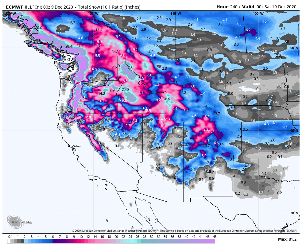
Looking out towards the end of next week, the models are hinting at a stronger system impacting a broad area of the west. The pattern stays active! The Cascades and the northern Rockies could see significant snowfall during this latter period if the models hold up. The Sierra may also be in the cards. That could set up a good pattern just in time for the XMAS holiday. Expect more powder days in the extended forecast as the models come into range of some accuracy.
Below: Fantasy dreaming! Total snowfall through Friday night next week (December 19th). Deterministic models are not very accurate that far out, but if everything holds up 2 foot totals are likely for many areas of the Rockies. The Ensembles which I have more confidence in show a continued trend for low pressure In the west. I'm optimistic.

This will be the last warm day in Denver for a while (65 today). Time to go biking, and get the boards ready for powder.
Powderchaser Steve


