Summary: Please consider joining our custom Powder Concierge program to book your deepest days of the season. We offer specific forecasts that include timing, temps, winds, conditions, custom maps, and timing to nab your deepest days. This also supports our forecasts!
Forecast:
The forecast from Thursday was on track with my prediction for 3-7 inches at Wolf Creek (They reported 5) and slightly less for Telluride (Reported 5, but snotel was on the lower side). My forecast for the ski areas west of the Divide was in range with Breckenridge reporting 4 inches Friday morning. This storm was a pure teaser as forecasted. In the PNW we highlighted Oregon where Timberline is reporting 5 inches this morning. Addtional snow is in the forecast for many areas.

In the short term forecast there is additional snow on the horizon. Currently another system, albeit stronger, will move in from the south impacting Colorado mid morning Saturday (Southern mountains) thorugh Sunday morning. Models generally appear to keep amounts in the 5-10 inch range with the higher ends likely being met in the south. This could be decent for Telluride, Silverton, Purgatory (6-9). Wolf Creek is wildcard with this storm likley in the range of 4-8. Timing is tricky to score pow since it will be snowing by mid morning Saturday in those locations. Go for last chair Saturday and 1st chair Sunday. Further north models show moderate amounts near Crested Butte, Aspen, and perhaps slightly less further East towards Summit County (3-7). Generally less snow will fall north of I-70 especially towards Steamboat. 1st chair Sunday at many resorts in Colorado will be met with fresh snow. If your'e picky, timing could also put the groomers on this new snow just as the bulk of precipitation is ending near midnight Saturday (Could be a bummer if it all gets groomed for your 1st chair Sunday).
Below: Total Preciptable water through Monday PM for Colorado. The highest amounts are in the northern San Juan Range, Perhaps near or just south of Wolf Creek Pass and northern NM initially. There are 2 storms to watch through Tuesday.

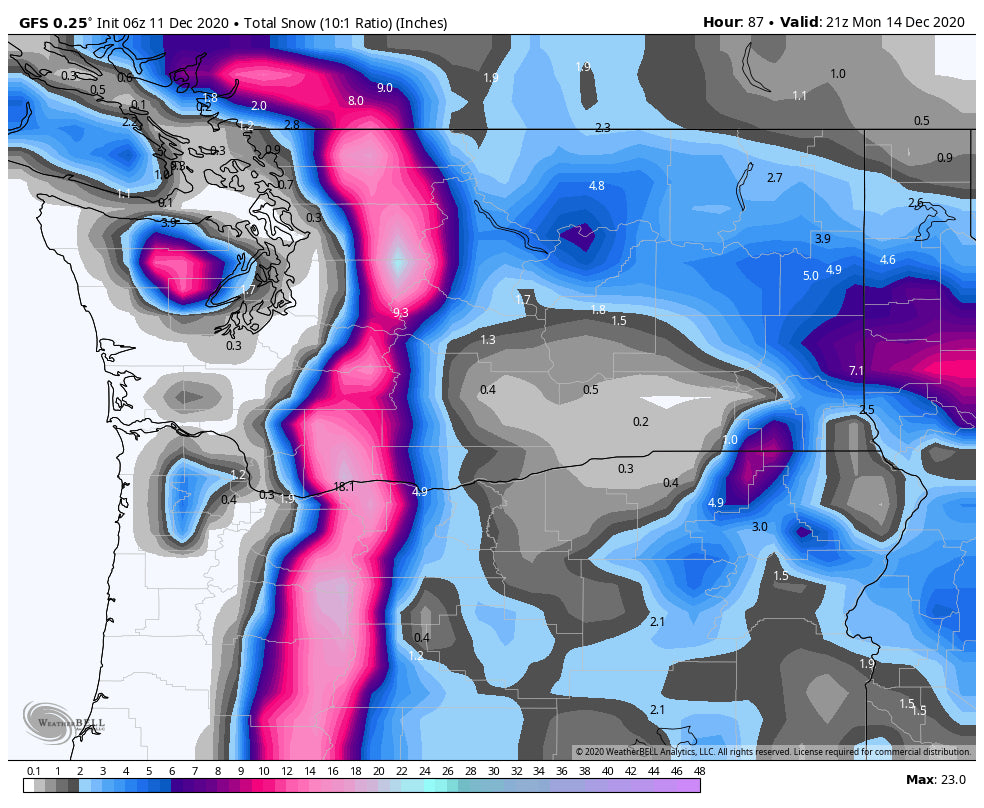
Elsewhere in the west, light or moderate snow is once again favoring southern Washington near the Oregon Cascades (Timberline, Mt Hood) for snowfall on Saturday. On Sunday snow intensifies in Oregon and extreme southern Washington early before spreading north by midday. Storm ski Oregon Sunday! Crystal, Stevens, and Mt. Baker Ski Area will all start to see moderate snowfall Sunday late AM into Monday morning. Amounts should be in the 7-11 inch range.
Below: Total snowfall for the Pacific Northwest through Monday afternoon. Pretty even spread. Oregon grabs a bonus on Saturday prior to WA seeing the highest snowfall Sunday late AM to Monday.

The Tetons and Wasatch see decent amounts late Sunday into Monday. Targhee and JHMR should awake to 4-8 inches Monday morning with the Wasatch seeing similar amounts (Slower timing). The eastern panhandle of Idaho will also see decent amounts.
Utah will also see snow on Saturday preceding this event favoring the southern and central mountain ranges (Brian Head, Eagle Point etc.). 4-8 inches are likley in these areas on Saturday. Chase south and then head north for Monday powder.
Hey, almost forgot! The Sierra grabs a moderate event late Friday night into Saturday favoring the southern regions. Kirkwood or areas south of Lake Tahoe such as Sierra at Tahoe could see the highest amounts (3-7 north lake, 6-10 south lake). Another system brings snow to most of the entire Sierra Range on Sunday (Storm Ski late) with an additional 5-8 inches for most resorts by Monday morning. Best days to ride powder will be PM Sunday while it is snowing and perhaps early Monday.
Below:The Sierra Range will see decent snowfall with 2 systems on Saturday and again late Sunday-Monday

Extended:
Snow should continue Sunday PM into Monday evening for the Wasatch bringing storm totals into the 5-10 inch range. The models have downtrended somewhat each day, with the latest run of the GFS taking the highest amounts towards Powder Mountain, and perhaps Beaver. I expect the Cottonwoods to see the 7-10 inch range by late Monday afternoon. Park City could approach 4-7 and areas north perhaps in the higher range. Models are not in consensus! Yesterday there was a clear signal of 12-18 storm totals for the Cottonwoods. Today that signal is more mixed. Lets hope it edges deeper again. These amounts will be updated. It would not surprise me if we have some uptick totals!
The longer range models bring addtional storms into the Pacific Northwest by Tuesday night and again on Thursday. BC may also score in this pattern favoring the southern regions. Moisture weakens as it moves east, but we could be see light refreshes for much of next week favoring the northern Rockies. A deeper system is possible for the Tetons and Wasatch by late next week. Its an active pattern.
Powderchaser Steve


