SUMMARY:
Cold air and heavy precipitation have blanketed the northern and central Cascades with 10-16 inches of cold smoke powder. The areas further south including Mission Ridge inland scored 2-5 inches. More snow is on the way for the Pacific Northwest this weekend. Leftovers for the northern Rockies.
FORECAST: Be sure to check out these early season prices on Ikon and renewal rates.
As forecasted, the northern Cascades got crushed last night with 16 inches at Mt Baker, 10 at Stevens Pass, with similar amounts along I-90 at Snoqualmie and Alpental. Snow will continue Thursday morning, especially over the central Cascades with a convergence zone. Snow showers will continue further north or south. Oregon likely saw some light snow as well. Many of us are living vicariously today including myself thinking today might be the best day of the season for for both depth and quality. Ironically November saw some of the coldest deep storms for the PNW and now we are in April and seeing La Nina roar in with cold temps and late season deep snow.
Here is a snapshot from the telemetry from the Mt Baker Ski area this morning showing 16-inch storm totals with snow still falling (Hourly precip). These are some of the coldest temps we have seen all season with these amounts so the quality should be epic! Henceforth the Epic Alert has been hoisted. Who is up there? Today will be great. More snow likely for the weekend.

Snow will taper off by 10 AM over the Cascades.
Elsewhere in the west, decaying moisture will move over the northern panhandle just south of Sandpoint and trickle over southern Montana and northern Wyoming Thursday. light or moderate snow is possible for Bridger, Big Sky, and Red Lodge Mountain late Thursday/Friday.
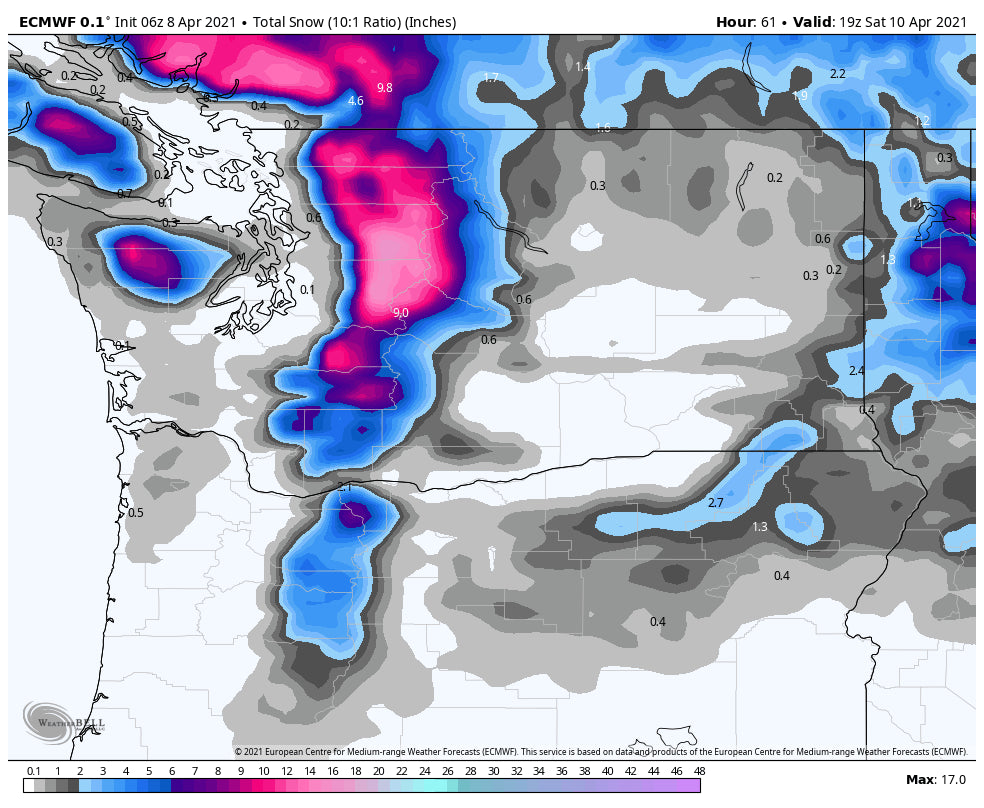
Yet another strong system moves ashore impacting British Columbia and the PNW Friday night into Saturday. This system might not be as deep, but could be close, bringing great conditions to the Cascades once again. The models also seem to favor the central Cascades near Stevens Pass. This should spread moderate snow south towards I-90 and some snow for the southern regions near Crystal and northern Oregon. Mt Baker will also be in scoring position but my early hunch is the highest amounts might fall just south. Early forecast amounts for the Cascades will be another 5-10 inches.
More on a later post! This might be my last week posting for the season. Please feel free to fund our forecasts with a donation if you have scored powder, lived vicariously, or just enjoy reading about snow. Thanks for all your support!
Powderchaser Steve


