Summary:
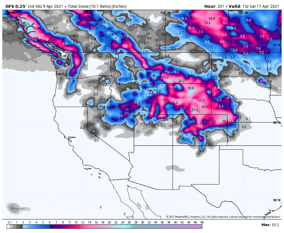
A final push of cold air will bring another good round of high-quality powder to the Cascades of Washington Friday night. Next week looks wet for the northern Rockies with some models showing significant high elevation snow for Colorado.
Forecast:
Cold temps and decent timing, will make chases to the Cascades a good option, and perhaps your last chance to score blower pow this season in the PNW. This will favor the central and Cascades including Stevens Pass, Mt Baker, and the eastern side of the Cascade Range near Wenatchee.
Bottom Line:
* Good timing with overnight snow for Saturday morning
Please check out the latest offering for early season renewal and pass rates from IKON.
* Cold temps with high quality
* Windier than the previous storm with 30-40 MPH gusts decreasing Saturday morning (Quality could vary)
* 7-10 inches is a safe forecast with perhaps higher amounts in the Central Cascades.
* Light to moderate amounts for areas along I-90 (5-7). Less further south with some snow for Crystal and OR.
Below: Winds are strong Friday night but decrease by the time lifts open on Saturday. Wind gusts might be highest over Stevens versus the far northern areas? SW direction switches W-NW late.

Below: American GFS indicating 7-10 inches from Mt Baker to Stevens and perhaps along or just north of I-90 for Saturday morning. This map is slightly less bullish for Baker than it is for Stevens (Others show higher amounts further north). Also, with cold temps amounts might exceed 10 inches in some locations. Light to moderate snow will fall Friday night in the southern Cascade Ranges. Aim to ride on Saturday.

Extended:
The one highlight of interest is a trend for very moist conditions to impact the west next week. This will come with a push of warm SW flow bringing a chance for some decent snow totals for both Colorado and perhaps the Wasatch Range of Utah. Temps are warm and it appears the highest amounts will be above 9,000 feet. Peak periods might come Tuesday (1st push of moderate snow) and increase late next week. It is possible that some ski resorts at the upper elevations pick up 12-15 inches of snow by the end of next week. Low elevation snow is also possible by the end of next week near Denver, however, if anything accumulates it will be on grassy surfaces or the higher foothills. Winds are SE along the Front Range similar to our 3-4 foot dump from March. Temps are much warmer with this storm so impacts will primarily be higher elevations.
Below: Next week brings high elevation wet snow favoring northern Utah (Wildcard) and the highest chances to north-central Colorado. This will likely favor resorts closest to the Front Range including the central mountains further south. Temps are on the warm side (Don't forget it is April), so cream or even some periods of decent powder (Especially late next week with a cooler trend) might surprise us. There are several periods of moisture next week with the first coming Tuesday and another decent wave Thursday/Friday. Caveat: Models are still 4-7 days out so only putting low to medium confidence on this solution. High confidence in a wetter trend for the Rockies.

Powderchaser Steve


