This will be an abbreviated post hopefully \Cutting to the chase\" quickly for the next 24 hours. Today saw very heavy snowfall in the Sierra for opening lifts. We had forecasted 12-18 inches and most resorts nabbed these amounts. Squaw tipped the scale at 19 inches for opening chairs this morning. If you were on KT 22 first thing please comment on this post as I almost chased there. I suspect it was epic with some wind impaction from the night before.
I mentioned yesterday that the majority of snowfall for opening lifts in Utah would be areas favored by SW flow. Brighton nailed 11 inches by 7 AM and Snowbasin had almost 9 just above the mid-mountain stake Little Cottonwood had 4-5 inches by 8 AM. The winds shifted to the west by mid-morning where most areas in Little and Big Cottonwood began full NUKING at 3 inches per hour around noon. Snowbird nabbed 20 inches by 2 PM (Storm total). Brighton and Solitude were just shy of that mark also with epic conditions. The Park City area especially Deer Valley overperformed the forecast with 7-10 inches. Today was the deepest day of the year for the Cottonwoods and by far my best Bird day in a long time. I won't say \"Best day ever\" and those that use that term keep using it! My best days ever are far in distant memory.
THE CHASE?
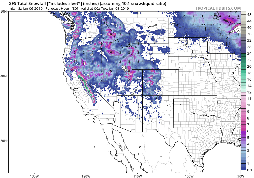
The Sierra is going to very deep again tonight. its a repeat event but with warmer temps. All bumps will be completely reset with 12-18 inches of additional medium to heavy density snowfall for most mountain locations including Mammoth. Mammoth will benefit from a higher elevation, lower temps, with better snow ratios (Perhaps higher totals at the summit). Wind will be very strong tonight before diminishing by morning. As of 5 PM, Pacific Time Squaw had 7 inches of new snow from the upcoming storm. Snow will be diminishing by early morning. It's an even spread of heavy snow over the entire range of the Sierra with the 15-19 inch range along the Crest. Avalanche danger will be increasing.
Below: Issued Sunday morning for storm #2 in progress currently! Warming temps and strong winds are contributing to these warnings along with another 12-18 inches of snow.

In the Cascades, I see good prospects for Crystal where snow levels are low and another 4-9 inches should fall through Monday. Conditions will be very good Monday morning. In Idaho, Sun Valley will see another 3-5 inches tonight (They benefit from the SW wind direction) with higher amounts in the northern Sawtooths. Chase in the Tetons and Wasatch will be deepest behind the Sierra totals. Models are showing 3-7 inches through Monday (Higher amounts possible). The issue in the Tetons will be very strong winds ramping up mid-morning or early afternoon. Gusts over 55 may impact lifts.
In Utah, models are more bullish for another 8-14 inches at the highest peaks of the Cottonwoods. The northern Wasatch will initially be favored (Snowbasin, Beaver) with SW winds that quickly shift westerly by early Monday. Park City mountains will see another 3-7 inch by late Monday. The Good: Decent fetch of moisture through Monday. The Bad: Strong winds at upper elevations (50-60 MPH) impacting lifts Monday morning. Slightly warmer temps on this storm with increasing Avy danger. Delayed openings. Consider lower elevation resorts or lifts Monday as a good portion of the Cottonwoods will be buttoned up Monday morning. PM may offer a better opportunity.
Snow stake at Snowbasin who picked up higher amounts initially Sunday morning.

Below: I shot this pic from the Tram Dock at Snowbird this afternoon at 3PM.

Finally, in Colorado, I am hopeful for some decent snow extending from Steamboat into Eagle County. There is likely to be some surprise totals favoring western areas along I-70 (Moderate to heavy snow). I have moderate confidence for Aspen (Light or moderate snow) and northern Gunnison County. It's not clear if the higher totals will extend to CB (wildcard). As of 7 PM, Mountain Time Beaver Creek had 5 inches on the webcams. Breckenridge seemed a bit east to me but also had decent snow falling on the webcams. They can sometimes sneak out surprises with West winds. Moderate snow will also be falling near Wolf Creek (National Weather has 6-12 for these areas but I am not buying into it). There will be others with no additional time to post details. Safest bets are western I-70 corridor.
Below: Total additional snowfall through Monday afternoon (Highlights in the Sierra, Utah, Tetons, WA Cascades, Sawtooths, Southern Panhandle)

The week ahead will feature a very moist period (Significant rain and snow) at upper elevations of much of the Sierra and specifically for the PNW and Whistler. Warm temps could produce some pretty wild conditions and chases may not be advised. BC offers slightly cooler temps and may offer a deep relatively cold dump by Thursday or Friday. More on a future post. I don't see any short-term chases currently past Monday.
Enjoy the powder everyone.
Powderchaser Steve


