Summary:
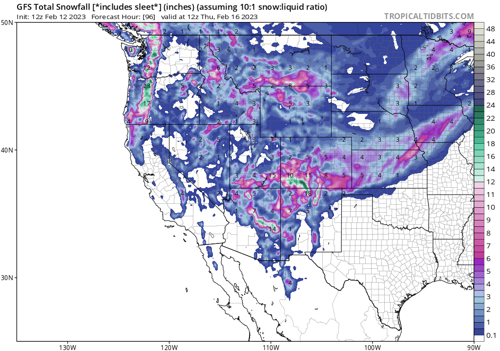
Low pressure enters the PNW and BC Sunday and drops due south skirting just east of the Sierra before cranking up big numbers in the 4 corners. Some areas will see 2 feet or more by Wednesday. Moisture also skirts north over the Rockies putting Montana in the spotlight.
Forecast-POW
This forecast is exciting with some deep numbers showing up on the chase picks for the upcoming week. Happy Super Bowl Sunday! Very warm conditions in the PNW migrate to cold on Monday with snow levels crashing from 5,000 feet to 500 feet! Some snow may fall near Seattle but it's unlikely to settle on the pavement. Moisture arrives for Whistler late Sunday and the northern Cascades near Mt Baker by Sunday evening. The central Cascades near Stevens or Snoqualmie will not see significant snow until early Monday morning with perhaps 4-6 inches on the early morning report and snow increasing near daylight. Amounts are likely to be higher early Monday further north where winds stay SW initially (Favors Baker). On Monday morning winds veer W-NW with some periods of due westerly flow which could form a Puget Sound Convergence Zone. Less snow will fall in the southern Cascades until midday Monday or overnight into Tuesday. Moderate snow is also noted for the interior of BC where heli operations and Revy will grab some much need snow. Oregon will do well with this storm with 12 inches plus for most resorts late Monday to Tuesday (Good timing).
Bottom Line PNW: Timing is not perfect in WA with the heaviest precipitation rates holding off until Monday early morning (Not huge overnight numbers especially in central or southern areas). Northern areas might see decent numbers by 6 AM Monday. Winds will be strong Sunday night but decrease by 9 AM Monday. Chase north Monday and gradually look at some good numbers for the central and southern Cascades PM Monday or early Tuesday (Oregon does well Monday night).
Below: The Cascades of Washington and Oregon will do well with this storm along a wide area from late Sunday through Tuesday morning (Further south). 12-17 inches are likely in many areas.

Rockies:
This system splits off some moisture for the northern Rockies combined with a deep cold front that looks to bring 12 inches or more for some areas of southern Montana night into Tuesday. While the panhandle of Idaho grabs moderate snow I would chase south and look for some decent numbers for Bridger Bowl (Big Sky wildcard) and Red Lodge. Less snow is noted for the Tetons Tuesday (3-7) as well as the Wasatch range which will see light to moderate snow.
Below: Strong cold front Monday night into Tuesday will kick off some decent snow rates for the northern Rockies and eastern Idaho. Resorts to watch might be Bridger, Big Sky, and even Red Lodge.

The biggest news will be the 4 corners region where up to 2 feet or more will fall in the San Juan range. Look for decent numbers for the Arizona Snowbowl late Tuesday to Wednesday. Significant snow will land in southern Colorado and northern New Mexico. Snow will be falling primarily Tuesday into Wednesday with good overnight numbers (Later start time) at Taos (Wednesday morning will be prime). You can ride powder by midday Tuesday and early Wednesday at many resorts in the San Juan Range. Snow will fall further north in the central Colorado mountains impacting Crested Butte and perhaps the Aspen areas mountain (Tuesday PM to Wednesday). Moderate snow is noted on the models for the I-70 corridor for Wednesday. I'm a bit speculative about what happens along I-70 with NE winds noted later Tuesday night which is not a good direction for heavy snowfall. The Front Range or areas closer to the Divide might sneak up a wildcard surprise.
Below: Arizona Snowbowl will do well with this storm Tuesday/Wednesday.

Below: Low pressure is centered in New Mexico Wednesday morning with snow falling in the 4 corners from Tuesday to late Wednesday pushing heavy moisture north into the southern and central Rockies. The northern areas of Colorado (I-70) will see moderate snowfall with some outlier surprises with NE Flow (Front Range perhaps? I am not confident just yet). Most resort snow will occur in the southern and central regions of Colorado and northern New Mexico and Arizona.

Below: Total snowfall for the San Juan Range including Taos will be healthy by late Wednesday (Moderate to heavy snow also possible from Telluride to CB, or Aspen). Northern areas will see snow as well with winds switching to the NE that might land some numbers for the Divide near Denver. Wolf Creek might report an excess of 2 feet by Wednesday night.

The extended period shows a trough moving ashore over the Sierra and dropping south by Sunday. The deterministic and ensembles don't show anything of significance with this system aside from light snowfall.
A series of storms are showing up on the ensembles in week #2 (February 20-26) that show an active period that could bring additional snowfall to the Pacific Northwest and areas of the Rockies. Look for additional chase opportunities to close out the month of February but being that far out comes with low confidence as of press time.
Please follow my Instagram chase @powderchasersteve and travel photos.
Powderchasers is now offering some great apparel, featuring high-quality US-made beanies and sweatshirts. This store will be expanded in the future but we are offering pre-release pricing on some great items. Please check out our store and support us with some Powderchasers gear that supports our site: https://powderchasers.com/store.
Don't forget to join our Concierge program for custom chase forecasts or donate here. Our concierge program will provide you custom forecasts to insure you get into the deepest snow (Our chase secrets). Donations keep our free forecasts going. Members rarely miss the deepest days.
See you on the first or last chair Monday.
Powderchaser Steve


